The best traffic-free bike rides around Kildare-Newbridge
5.0
(2)
9
riders
3
rides
No traffic gravel bike trails around Kildare-Newbridge are characterized by a generally flat landscape, rich pastures, and the plains of the Bog of Allen. Major rivers like the Liffey, Barrow, and Boyne flow through parts of the region, complementing the network of greenways and historic canal towpaths. The area also features mixed woodlands, offering varied terrain for gravel biking.
Best no traffic gravel bike trails around Kildare-Newbridge
- The most popular no traffic gravel bike trail is From Blessington to Sorrel…
Last updated: July 10, 2026
5.0
(2)
5
riders
27.9km
02:37
560m
560m
This difficult 17.3-mile gravel biking loop near Blessington offers challenging terrain, 1828 feet of climbing, and panoramic views.
5.0
(1)
1
riders
44.3km
03:14
660m
650m
This difficult 27.5-mile gravel biking loop from Dunlavin offers remote beauty and expansive views in the Wicklow Mountains.

Sign up for free
4
riders
46.4km
02:46
120m
120m
Moderate gravel ride. Good fitness required. Mostly paved surfaces. Suitable for all skill levels.
Our route recommendations are based on thousands of hikes, rides, and runs completed by other people on komoot.
Start today with a free account
Your next adventure awaits.
Login or Signup

Other adventures around Kildare-Newbridge

Tips from the Community

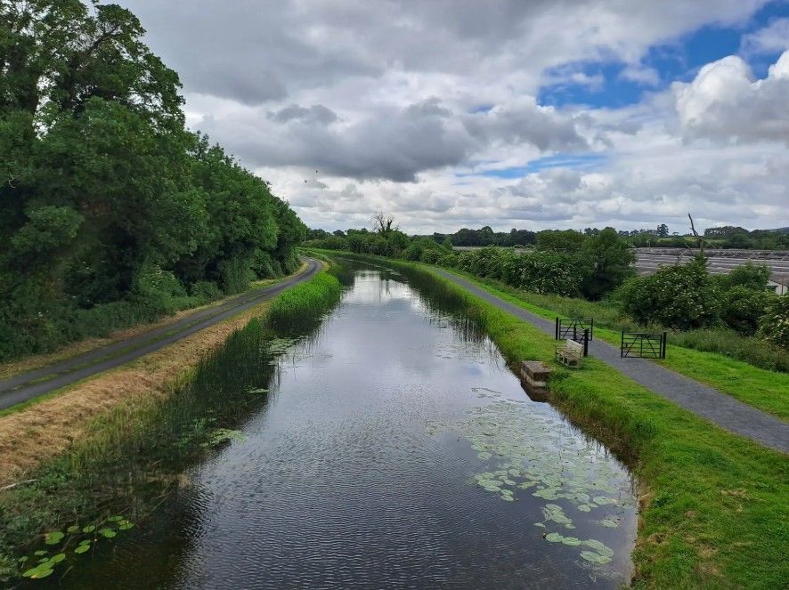
On this stretch, you follow a quiet, peaceful path right alongside the canal, making it ideal if you’re looking to slow down and enjoy nature. It’s a great spot to take in the stillness, listen to the water, and enjoy a relaxed walk at your own pace. You won't encounter many people here.
0
0
Blessington is a bustling market town set above Poulaphouca Reservoir, where the Wicklow Mountains meet the Kildare plains. Its broad main street is lined with cafés, pubs and shops. Just outside town lies Russborough House, a grand Palladian mansion with gardens, art collections, and walking trails, while the lakes themselves are popular for fishing, sailing, and quiet scenic walks.
0
0

Bike rental, mechanic and coffee. Great place to stop
0
0


The Poulaphouca Reservoir, located near Blessington in County Wicklow, Ireland, is a large man-made reservoir created in the 1930s by the construction of the Poulaphouca Dam on the River Liffey. It was built primarily to supply water to Dublin, and its creation led to the formation of Blessington Lake. The reservoir is an important part of Dublin's water supply system and is also a popular spot for recreational activities, as well as offering stunning views of the surrounding countryside.
1
0
Blessington is a town located in County Wicklow, situated about 29 kilometres southwest of Dublin. It is known for its scenic surroundings, including Blessington Lake, which is part of the River Liffey's reservoir system.
0
0
The River Liffey is approximately 125 kilometers long, flowing from its source in the Wicklow Mountains to its mouth at Dublin Bay and the Irish sea. The river has been a crucial part of Dublin’s history, playing an important role in the city's development, trade, and transport.
0
0
Donard is a village in County Wicklow, Ireland, located at the northern end of the Glen of Imaal in the western part of the Wicklow Mountains. The name "Donard" comes from the Irish "Dún Ard," meaning "high fort," and the ruins of such a fort are still visible above the town.
0
0
Frequently Asked Questions
How many no-traffic gravel bike trails are available in Kildare-Newbridge?
This guide features 3 carefully selected no-traffic gravel bike trails in the Kildare-Newbridge area, offering a range of experiences from moderate to difficult. These routes are designed to keep you away from busy roads, allowing you to enjoy the region's natural beauty.
What kind of terrain can I expect on the no-traffic gravel bike trails in Kildare-Newbridge?
The no-traffic gravel trails in Kildare-Newbridge offer a mix of terrain. You'll find routes that traverse extensive greenways, historic canal towpaths, and mixed woodlands. While some routes feature mostly paved surfaces, others, like the From Blessington to Sorrel hill loop, include significant climbing and panoramic views, heading towards the foothills of the Wicklow Mountains.
Are there any beginner-friendly or easier no-traffic gravel bike routes in the area?
While many routes offer a challenge, the region does provide options for varying skill levels. For a moderate experience, consider the Coffee Stop at Digby Bridge – Sallins loop from Newbridge. This route offers a substantial distance of over 46 km with more gentle elevation changes, making it a good choice for those looking for a less strenuous ride compared to the more difficult mountain-adjacent loops.
What are the typical distances for no-traffic gravel bike routes in Kildare-Newbridge?
The no-traffic gravel bike routes in Kildare-Newbridge vary in length, generally ranging from around 28 km to over 46 km. For instance, the From Blessington to Sorrel hill loop is about 28 km, while the Coffee Stop at Digby Bridge – Sallins loop from Newbridge extends to over 46 km, providing options for different endurance levels.
What interesting landmarks or natural features can I see along the no-traffic gravel bike trails?
Kildare-Newbridge's trails often pass by significant natural and historical sites. You might encounter features like the Canal Gate on Cycling Route along canal paths, or explore areas near Bluebell Forest, Kildare. The region is also home to unique natural features like Pollardstown Fen, Ireland's largest spring fen, and the expansive Curragh Plains.
Are there any circular no-traffic gravel bike routes in Kildare-Newbridge?
Yes, several no-traffic gravel bike routes in Kildare-Newbridge are designed as loops, allowing you to start and finish at the same point. Examples include the challenging Glen of Ival loop from Dunlavin, which offers remote beauty and expansive views, and the moderate Coffee Stop at Digby Bridge – Sallins loop from Newbridge.
What do other gravel bikers enjoy most about the no-traffic trails in Kildare-Newbridge?
The komoot community highly rates the outdoor experiences in Kildare-Newbridge, with an average score of 5.0 stars. Reviewers often praise the region's diverse landscapes, the quiet nature of the trails, and the blend of natural beauty with cultural and historical interest found along routes like the Royal Canal Greenway.
Are there family-friendly no-traffic gravel biking options in Kildare-Newbridge?
While the routes in this guide are rated moderate to difficult, the broader Kildare-Newbridge area offers family-friendly outdoor spaces. For example, the Liffey Linear Park in Newbridge provides a natural play area, and Donadea Forest Park features mixed woodlands and historical elements, which can be explored by bike on suitable paths. When choosing a route, consider the distance and elevation to match your family's skill level.
Can I find cafes or amenities near the no-traffic gravel bike trails?
Yes, many routes in the Kildare-Newbridge area are designed to pass through or near towns and villages where you can find amenities. For instance, the Coffee Stop at Digby Bridge – Sallins loop from Newbridge explicitly mentions a coffee stop, indicating that refreshments are accessible along the way. Planning your route with komoot allows you to identify such points of interest.
What is the best time of year to gravel bike in Kildare-Newbridge?
Kildare-Newbridge offers enjoyable gravel biking throughout much of the year. Spring brings vibrant bluebells and wild garlic to woodlands like Killinthomas Woods, while summer provides longer daylight hours. Autumn showcases beautiful foliage. Even in winter, many trails remain accessible, though conditions can be wetter. Always check local weather forecasts before heading out.
Are there opportunities for wildlife spotting on these no-traffic gravel trails?
Yes, the natural landscapes of Kildare-Newbridge provide opportunities for wildlife spotting. Areas like Pollardstown Fen are known for rare plants and bird species. Riding through mixed woodlands and along canal towpaths can offer glimpses of local fauna. Keep an eye out, especially during quieter times of day, for various birds and small mammals.
Most popular routes around Kildare-Newbridge
Most popular attractions around Kildare-Newbridge

Get inspired with the komoot mobile app


Explore more
Browse the best Gravel rides in other regions.
