The best hikes from bus stations in Mookerheide
4.4
(14873)
79,049
hikers
1,133
hikes
Hiking in Mookerheide offers diverse landscapes, characterized by extensive heathlands, woodlands, and small fens. The terrain is notably hilly, a result of geological processes, providing varied inclines and descents. From various vantage points, hikers can enjoy views over the Maas river. The region also features historical fortifications and landmarks, adding to the experience of its bus station hiking trails.
Best bus station hiking trails in Mookerheide
- The most popular bus station hiking route is Groesbeek Forestry – Mookerheide Heath loop…
Last updated: June 25, 2026
4.7
(227)
1,062
hikers
Moderate hike. Good fitness required. Easily-accessible paths. Suitable for all skill levels.
4.7
(27)
113
hikers
9.58km
02:34
110m
110m
Moderate hike. Good fitness required. Easily-accessible paths. Suitable for all skill levels.

Sign up for free
3.7
(19)
78
hikers
Easy hike. Great for any fitness level. Easily-accessible paths. Suitable for all skill levels.
4.9
(36)
106
hikers
Moderate hike. Good fitness required. Easily-accessible paths. Suitable for all skill levels.
4.9
(14)
57
hikers
Hard hike. Very good fitness required. Easily-accessible paths. Suitable for all skill levels.
Get access to more routes and recommendations from other explorers.
Sign up for free
Already have an account?
Our route recommendations are based on thousands of hikes, rides, and runs completed by other people on komoot.
Start today with a free account
Your next adventure awaits.
Login or Signup


Tips from the Community


The Mookerheide is a forest and heathland area east of Mook in the municipality of Mook en Middelaar in the north of the Dutch province of Limburg. The heathland and the surrounding area around Mook were the scene of warfare during both the Eighty Years' War and the Second World War. The fighting resulted in many casualties. The nature reserve has been managed by Natuurmonumenten since 1985. The battle did not actually take place near what is now the largest remaining heathland area near Bisselt, but on the north side of the village center of Mook, between the Maas river and the Bovensteweg. Several thousand Dutch soldiers were killed. Many of those who fled south perished in the marshlands south of Mook. Near Molenhoek, the Heumense Schans defensive structure can still be seen in the landscape. Source and more information: Wikipedia
2
0

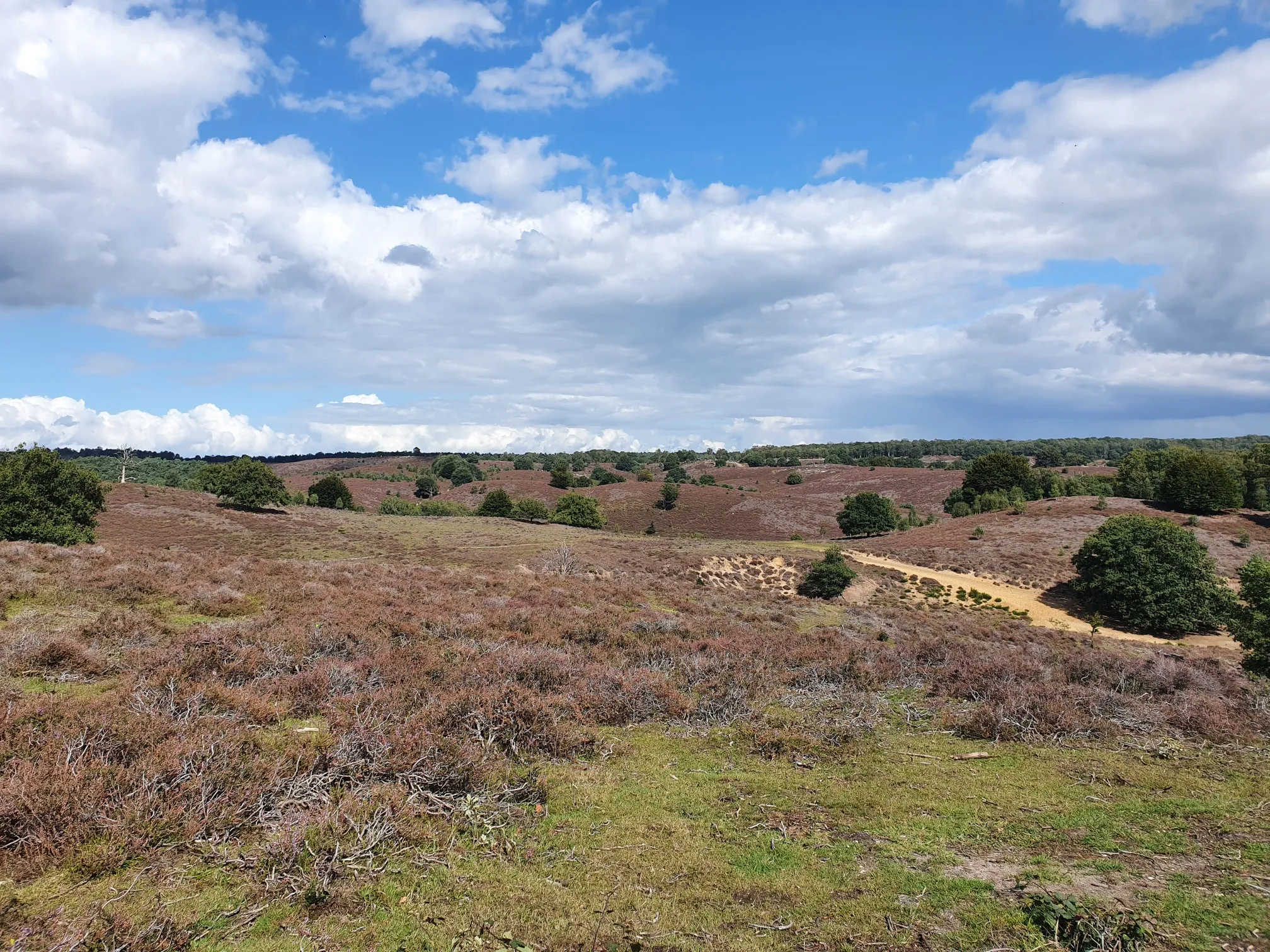
A beautiful, large, hilly heathland area with a view of the Maas
0
0
A beautiful large heathland area, where cattle also graze to keep the grass short
1
0
Beautiful heathland here, and a good view of the surroundings. You can see far in clear weather.
0
0
Lots of heather here on the Mokerheide
1
0


Had a very nice day, very nice trip
2
0
Frequently Asked Questions
How many bus station hiking trails are available in Mookerheide?
There are 12 hiking trails in Mookerheide that are easily accessible from bus stations. These routes vary in length and difficulty, offering options for different preferences.
Are there easy hiking routes from bus stations in Mookerheide suitable for beginners or families?
Yes, Mookerheide offers 6 easy hiking routes accessible from bus stations. An excellent option is the Mookerschans Observation Tower – Steep Slopes Trail loop from Mook en Middelaar, which is approximately 6.5 km long and features moderate elevation changes, making it suitable for a relaxed outing.
What kind of landscapes can I expect to see on bus station hikes in Mookerheide?
The bus station hikes in Mookerheide traverse diverse landscapes. You'll experience extensive heathlands, which are particularly vibrant and purple around mid-August, interspersed with woodlands and charming *vennetjes* (small fens). The terrain is notably hilly, offering varied inclines and descents, and from various points, you can enjoy expansive views over the Maas river and Cuijk.
Are there any circular hiking routes from bus stations in Mookerheide?
Many of the bus station hikes in Mookerheide are circular, allowing you to start and end at the same point, often conveniently near a bus stop. For example, the Groesbeek Forestry – Mookerheide Heath loop from Mook en Middelaar is a moderate 8 km circular route that showcases the region's natural beauty.
What historical landmarks or viewpoints can I discover along the bus station trails?
Along the bus station trails, you can explore several historical landmarks and enjoy panoramic views. Notable sites include the 17th-century fortifications like the Heumense Schans and the Mookerschans Observation Tower, which offers stunning vistas. The elegant Jachtslot Mookerheide (hunting lodge) is also a prominent landmark often included in routes.
What is the best time of year to hike in Mookerheide from a bus station?
Mookerheide is beautiful year-round, but the heathlands are particularly spectacular around mid-August when they bloom into a vibrant purple. Spring and autumn also offer pleasant hiking conditions with colorful foliage and milder temperatures. The area is generally less crowded than other nature reserves, allowing for a peaceful experience any time.
Are there any longer, more challenging bus station hikes in Mookerheide?
Yes, for those seeking a longer excursion, the Mookerheide Heath – Heumense Schans loop from Mook en Middelaar is a moderate 12 km route with over 100 meters of elevation gain, providing a more extensive exploration of the region's diverse landscapes and historical sites.
What do other hikers enjoy most about hiking in Mookerheide?
The komoot community highly rates hiking in Mookerheide, with an average score of 4.4 stars. Reviewers often praise the tranquil escape offered by the diverse landscapes, the stunning purple heathlands in late summer, and the varied terrain that provides both gentle strolls and more challenging inclines. The historical fortifications and expansive views are also frequently highlighted.
Can I spot any wildlife or unique natural features on these trails?
Mookerheide is a crucial ecological corridor, so you might spot rare reptiles like sand lizards and smooth snakes. Birdwatchers can look out for diverse species, including woodpeckers, hawkers, and the nocturnal nightjar. The region is also known for its charming *vennetjes* (small fens) and an almost horizontally grown oak tree along the Apostelweg.
Where can I find more information about Mookerheide's walking routes?
For additional information about walking routes and the Mookerheide region, you can visit visitmookerheide.nl. This resource can complement the komoot routes by providing broader regional context.
Are there any bus station routes that offer views of the Maas river?
Yes, several routes in Mookerheide provide expansive views over the Maas river. The hilly terrain, a result of geological processes, creates natural vantage points. While specific routes are not named for river views, many trails, such as the Mookerschans Observation Tower – Mookerheide loop from Mook en Middelaar, will offer glimpses of the surrounding lowlands and the river.
Most popular routes in Mookerheide
Most popular attractions in Mookerheide

Get inspired with the komoot mobile app


Explore more
Browse the best Hikes in other regions.
