Top 11 Natural Monuments in the Abajo Mountains
Best natural monuments in the Abajo Mountains are found within this remote range in southeastern Utah, characterized by its unique laccolithic geological origins and high-altitude forests. The mountains offer a striking contrast to the arid desert surroundings, supporting diverse ecosystems with pine, fir, and aspen forests. Historically, the Abajo Mountains served as ancestral hunting grounds for Native American tribes and are part of the Manti-La Sal National Forest, underscoring their natural and cultural importance. This area provides a secluded wilderness experience with expansive views.
Best natural monuments in the Abajo Mountains
- The most popular natural monuments is Sipapu Bridge, a natural_monument that features an amazing combination of a mostly dry river valley and a monumental stone bridge. Access to the bottom is possible via ladders and railings.
- Another must-see spot is Goosenecks State Park Viewpoint, a viewpoint offering a brilliant view of one of the loops of the canyon. The formations of the canyon resemble goose necks from a bird's eye view.
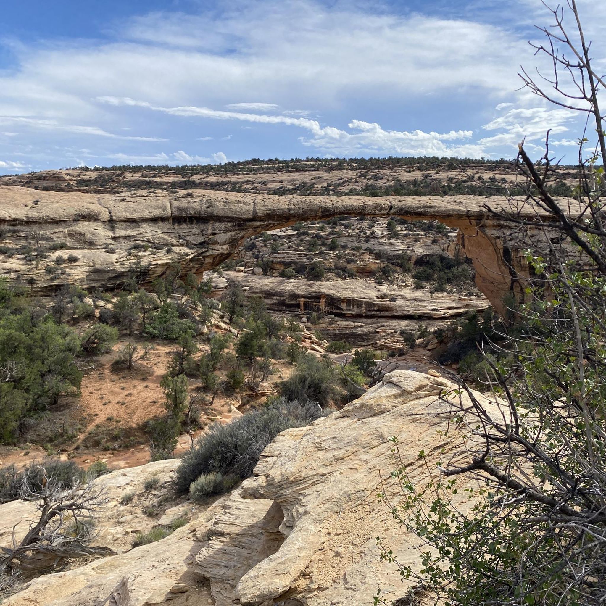
- Visitors also love Owachomo Bridge, a natural bridge. This delicate bridge is likely the oldest natural bridge in the park and was named for a large rock mound on its left side.
- Abajo Mountains is known for its natural bridges, viewpoints, and unique rock formations. Visitors can explore a variety of natural monuments, including geological features and scenic overlooks.
- The natural monuments in the Abajo Mountains are appreciated by the komoot community, with 14 upvotes and 52 photos shared.
Last updated: July 10, 2026
Sipapu Bridge
Highlight • Natural Monument
Tip by

Kachina Bridge Trailhead
Highlight • Parking
Tip by
Sign up now to discover places like this
Get recommendations on the best single tracks, peaks, & plenty of other exciting outdoor places.
Sign up for free
Goosenecks State Park Viewpoint
Highlight • Viewpoint
Translated by Google •
Tip by

Owachomo Bridge
Highlight • Natural Monument
Tip by

House on Fire / Mule Canyon
Highlight • Historical Site
And it burns if you take photos in the right place and the right spot.
beautiful, I'm totally thrilled.
Mega photo hotspot
Translated by Google •
Tip by

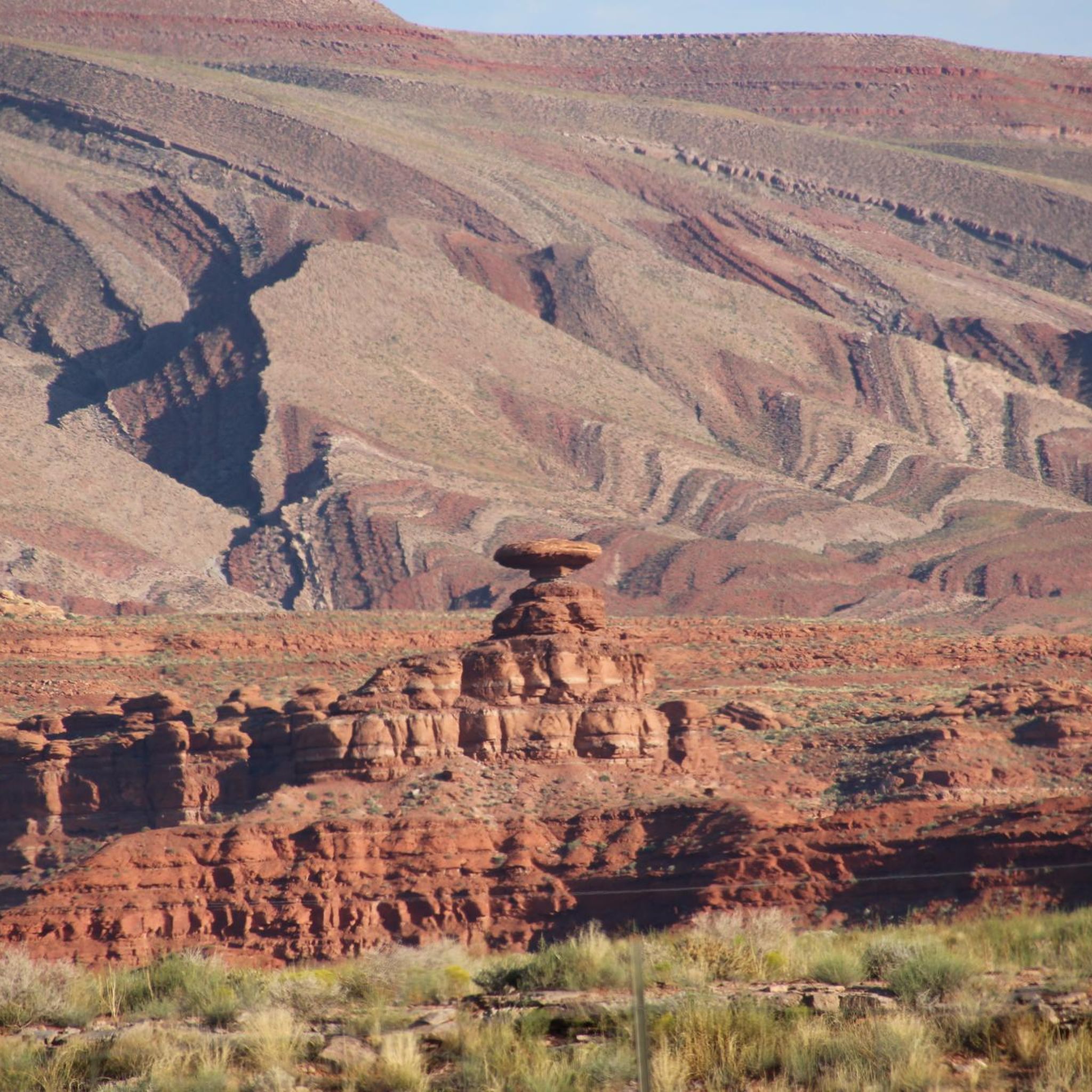
Mexican Hat Rock
Highlight • Natural Monument
Translated by Google •
Tip by
Newspaper Rock Petroglyphs
Highlight • Historical Site
americansouthwest.net/utah/canyonlands/newspaper-rock.html
The petroglyphs from Newspaper Rock are from different eras, look beautiful and interesting, but are not decipherable for a layman like me.
It was definitely worth the long walk from the parking lot to Newspaper Rock, which is almost 200 meters long.
Translated by Google •
Tip by

House on Fire
Highlight • Historical Site
Translated by Google •
Tip by
Moki Dugway
Highlight (Segment) • Mountain Pass
Translated by Google •
Tip by
Muley Point Viewpoint
Highlight • Viewpoint
Tip by

Sign up for free to discover even more natural monuments in the Abajo Mountains.
Sign up for free
Already have an account?
Start today with a free account
Your next adventure awaits.
Login or Signup
Popular around Abajo Mountains

Other adventures in the Abajo Mountains

Tips from the Community

Lovely walk in the afternoon sun, plenty of shade and great underfoot.
1
0

Utah State Route 261 runs through Bears Ears National Monument. One section of the highway is called the Moki Dugway. This section climbs 335 m over a length of 4.8 km. The upper section of the road is unpaved, but the lower section is paved.
6
0
A very interesting and beautiful hike leads to the small cliff dwellings and storerooms of the Anasazi in Lower Mule Canyon.
4
0
A very interesting and beautiful hike leads to the small cliff dwellings and storerooms of the Anasazi in Lower Mule Canyon.
4
0
a beautiful view of the San Juan River, I am always amazed by this view, super beautiful, the fee is definitely worth it and it is also pretty deserted there, not as crowded as at Horseshoe Bend, where the parking fee is now 10 dollars, so the 5 dollars is not so bad
4
0
a dream, beautiful nature leads to the House of Fire. And it burns if you take photos in the right place and the right spot. beautiful, I'm totally thrilled. Mega photo hotspot
4
0

Owachomo Bridge is likely the oldest natural bridge in the park. This delicate bridge was named for the large rock mound on its left side; Owachomo is a Hopi word for “rock mound.”
1
0

Nice view of the loop. The “right” time of day is important for photos! Nice picnic area - take something with you for a leisurely break... Otherwise the entrance fee isn't actually worth it.
4
0
Frequently Asked Questions
What are some must-see natural monuments in the Abajo Mountains?
The Abajo Mountains region is home to several remarkable natural monuments. Don't miss Sipapu Bridge, an impressive natural arch with access via ladders and railings. Another highlight is Goosenecks State Park Viewpoint, offering a brilliant perspective of the San Juan River's winding loops. Also, consider visiting Owachomo Bridge, known as the oldest and most delicate natural bridge in the area.
What unique natural features define the Abajo Mountains?
The Abajo Mountains are distinct for their laccolithic formation, meaning they formed as magma pushed through sandstone layers, creating dome-shaped bulges rather than erupting. This geological process results in their rounded peaks. The range also features high-altitude pine, fir, and aspen forests, which stand in striking contrast to the surrounding arid desert, creating 'islands of green forests' with cooler, wetter conditions.
When is the best time to visit the natural monuments in the Abajo Mountains?
The Abajo Mountains offer diverse experiences throughout the year. For hiking, mountain biking, and exploring the natural monuments, late spring through early fall (May to October) generally provides the most favorable weather. The aspen forests turn golden in the fall, creating a vibrant display. In winter, the snow-covered terrain is ideal for cross-country skiing, backcountry skiing, snowshoeing, and snowmobiling, offering a different kind of wilderness experience.
Are there family-friendly natural monuments or trails in the Abajo Mountains?
Yes, several natural monuments and nearby trails are suitable for families. Goosenecks State Park Viewpoint and Mexican Hat Rock are both categorized as family-friendly viewpoints. Additionally, the Newspaper Rock Petroglyphs site offers an accessible historical and natural monument experience for all ages. For easy hikes, consider routes like the Sipapu Bridge Trail or Mule Canyon Trail to House on Fire, which are listed in the Easy hikes in the Abajo Mountains guide.
What kind of outdoor activities can I do near these natural monuments?
The Abajo Mountains are a haven for outdoor enthusiasts. Beyond visiting the natural monuments, you can enjoy hiking, mountain biking, and horseback riding. In winter, activities include cross-country skiing, backcountry skiing, snowshoeing, and snowmobiling. For specific hiking routes, explore guides like Hiking in the Abajo Mountains or Running Trails in the Abajo Mountains.
Are there easy hiking trails to access the natural monuments?
Yes, there are several easy hiking options to reach or view the natural monuments. The Easy hikes in the Abajo Mountains guide features routes like the Sipapu Bridge Trail and the Mule Canyon Trail to House on Fire, both rated as easy. For a view of Sipapu Bridge without a full descent, the View of Sipapu Bridge lookout point is easily accessible.
Where can I find the best panoramic views in the Abajo Mountains?
For breathtaking panoramic views, consider visiting Goosenecks State Park Viewpoint, which offers a spectacular perspective of the San Juan River's meanders. Another excellent spot is Muley Point Viewpoint, known for its expansive vistas. The Abajo Loop Scenic Byway and the South Creek Road to Abajo Peak also provide numerous overlooks with views stretching for hundreds of miles.
What is the geological history behind the Abajo Mountains' unique formations?
The Abajo Mountains are geologically unique as one of only two volcanic ranges in southeastern Utah, formed approximately 35 million years ago. They are laccoliths, meaning magma pushed up through cracks in existing sandstone layers, creating dome-shaped mountains rather than erupting. This process resulted in their characteristic rounded peaks and contributed to the formation of the natural bridges and canyons seen today.
Do the Abajo Mountains hold any cultural or historical significance?
Yes, the Abajo Mountains are rich in cultural and historical significance. They were historically ancestral hunting grounds for several Native American tribes and remain important to tribal peoples of the Colorado Plateau region. The area is also part of the Manti-La Sal National Forest and partially falls within Bears Ears National Monument, highlighting its natural and cultural importance. Sites like Newspaper Rock Petroglyphs and House on Fire / Mule Canyon offer glimpses into ancient civilizations.
What wildlife might I encounter in the Abajo Mountains?
The diverse ecosystems of the Abajo Mountains, with their high-altitude forests and numerous waterways, support a variety of wildlife. Visitors might encounter deer, elk, and bears. The cooler, wetter conditions compared to the surrounding desert create a vital habitat for these species.
How much time should I plan for visiting the natural monuments?
The time needed depends on which natural monuments you wish to visit and your activity level. For a quick overview of a few viewpoints like Goosenecks State Park or Mexican Hat Rock, a few hours might suffice. However, to fully explore sites like Natural Bridges National Monument, including hikes to Sipapu Bridge, Owachomo Bridge, and Kachina Bridge, you could easily spend a full day or more, especially if you opt for longer loop trails.
Is it possible to visit the natural monuments in the Abajo Mountains during winter?
While some roads and trails might be less accessible due to snow, visiting in winter offers a unique experience. The snow-covered terrain transforms the landscape, making it ideal for activities like cross-country skiing, snowshoeing, and snowmobiling. Always check local conditions and road closures before planning a winter visit, as higher elevations can receive significant snowfall.
Most popular routes in the Abajo Mountains
Most popular attractions in the Abajo Mountains

Get inspired with the komoot mobile app


Explore more
Extend your search for the best caves by checking out these guides of the top ones in the Abajo Mountains:
