The best family-friendly hikes and walks around Whaley Bridge
4.5
(1382)
8,509
hikers
92
hikes
Family friendly hiking trails around Whaley Bridge are set within the western edge of the Peak District National Park, offering diverse landscapes for outdoor exploration. The area features prominent gritstone hills like Eccles Pike, providing expansive views, alongside picturesque reservoirs such as Toddbrook Reservoir and Combs Reservoir. The River Goyt flows through the region, contributing to the scenic Goyt Valley, which is characterized by forested hills and ancient stone walls. The Peak Forest Canal also provides relatively flat walking paths.
Best family friendly hiking trails around Whaley Bridge
- The most popular family friendly hiking route is Torrs Hydro, New Mills – Queen's Bridge loop from Whaley Bridge, a 6.8 miles (10.9 km) trail that takes about 2 hours 50 minutes to complete. This route offers views of the Torrs Gorge and the Peak Forest Canal.
- Another top favourite among local hikers is Eccles Pike – Bugsworth Basin loop from Whaley Bridge, a moderate 7.2 miles (11.6 km) path. This trail includes an ascent to Eccles Pike, offering panoramic vistas, and passes by the historic Bugsworth Basin.
- Local hikers also love the Hillbridge Wood – View of Fernilee Reservoir loop from Whaley Bridge, a 9.6 miles (15.4 km) trail leading through woodland and past Fernilee Reservoir, often completed in about 4 hours 20 minutes.
- Hiking around Whaley Bridge is defined by gritstone hills, scenic reservoirs, and canal paths. The network offers options for various ability levels, from waterside strolls to more strenuous moorland hikes.
- The routes in Whaley Bridge are highly rated by the komoot community with an average score of 4.5 stars from over 1300 reviews. More than 8000 hikers have used komoot to explore Whaley Bridge's varied terrain.
Last updated: July 1, 2026
4.5
(31)
275
hikers
19.6km
05:40
490m
490m
Hard hike. Very good fitness required. Easily-accessible paths. Suitable for all skill levels.
4.6
(25)
109
hikers
11.6km
03:21
280m
280m
Moderate hike. Good fitness required. Easily-accessible paths. Suitable for all skill levels.

Sign up for free
4.5
(22)
142
hikers
15.6km
04:23
320m
320m
Moderate hike. Good fitness required. Easily-accessible paths. Suitable for all skill levels.
4.3
(10)
74
hikers
15.1km
04:20
360m
360m
Moderate hike. Good fitness required. Easily-accessible paths. Suitable for all skill levels.
4.6
(10)
82
hikers
10.9km
02:50
70m
70m
Moderate hike. Good fitness required. Easily-accessible paths. Suitable for all skill levels.
Get access to more routes and recommendations from other explorers.
Sign up for free
Already have an account?
Our route recommendations are based on thousands of hikes, rides, and runs completed by other people on komoot.
Start today with a free account
Your next adventure awaits.
Login or Signup

Tips from the Community

Visited early evening and had the pleasure of seeing an RAF Atlas doing low level flying
0
0

Torr Mill: Owned by the Schofield family, this mill was constructed in 1794. Originally five stories tall, it burned down in 1912. The Community Hydro Scheme turbine now uses its old waterwheel housing. The mill was used for cotton spinning and later linen manufacture
0
0

Have to agree with others... plenty to see especially at the weekend & the Navigation pub is good for food & drink...
0
0


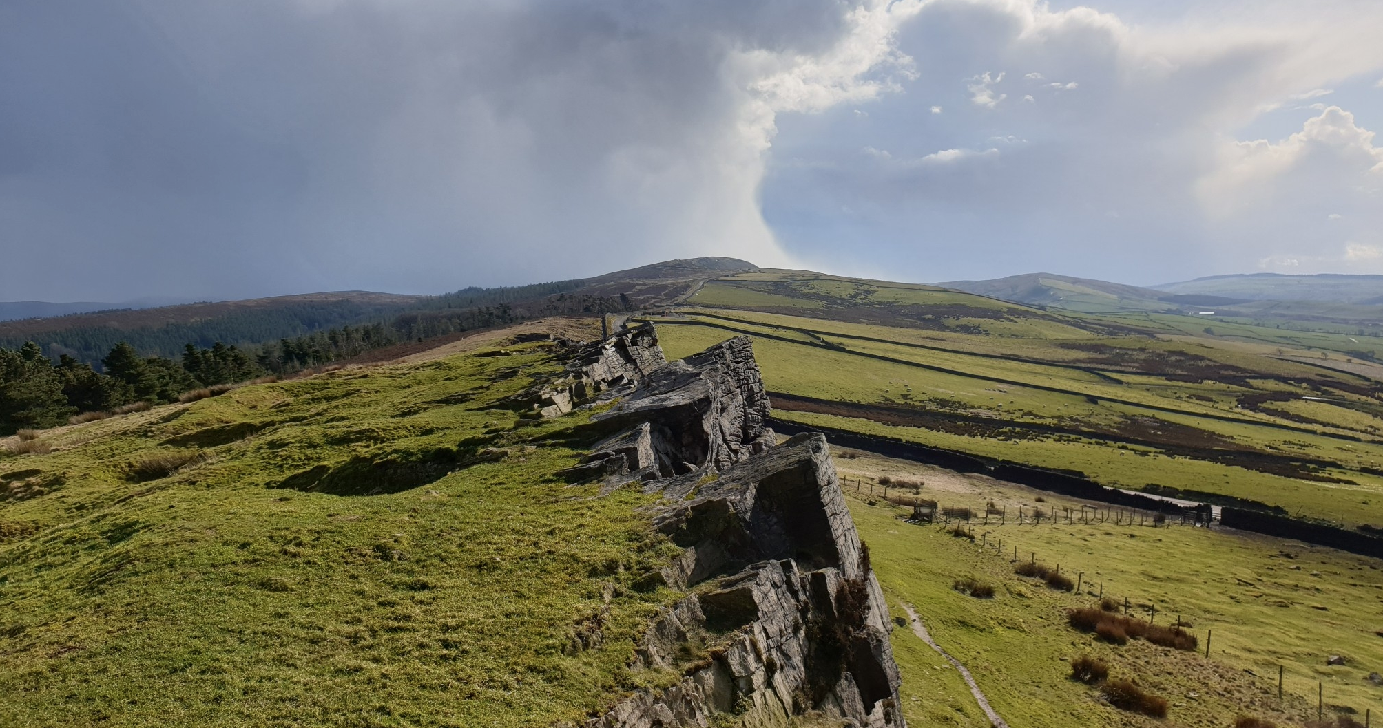
The wonderfully named Windgather Rocks is a grand gritstone crag that's popular with climbers, offering steep, juggy routes. It provides superb views across the national park. The crag is part of the ridge system that extends south along the Cheshire Derbyshire border, culminating in Shining Tor, Cheshire's highest point.
1
0

It's asking for a rolly polly
0
0
Frequently Asked Questions
How many family-friendly hiking trails are there around Whaley Bridge?
Whaley Bridge offers a wide selection of routes suitable for families, with over 40 easy and 40 moderate trails available. In total, there are nearly 100 hiking routes to explore in the area.
What kind of terrain can families expect on hikes near Whaley Bridge?
Families can enjoy a diverse range of terrain. Many routes follow gentle waterside paths along the picturesque reservoirs like Toddbrook Reservoir and Combs Reservoir, or the historic Peak Forest Canal. For those seeking a bit more adventure, there are trails that ascend gritstone hills such as Eccles Pike, offering rewarding views without being overly strenuous for active families.
Are there any circular walks suitable for families in Whaley Bridge?
Yes, Whaley Bridge is excellent for circular walks. Many trails are designed as loops, making them convenient for families. For example, the Eccles Pike – Bugsworth Basin loop offers a moderate challenge with historical interest, while the Combs Reservoir provides a peaceful 2-mile circular route perfect for a leisurely family stroll.
What are some notable landmarks or natural features to see on family hikes?
Families can discover a variety of interesting sights. The area is rich with reservoirs like Errwood Reservoir and Toddbrook Reservoir, offering beautiful waterside views. The historic Bugsworth Basin, once a busy inland port, is a fascinating stop. For unique views, the Millennium Walkway in the Torrs Gorge is a striking feature. You can also find impressive natural monuments like Shining Tor trig point and Edale Rocks on some of the longer routes.
Are the family-friendly trails around Whaley Bridge dog-friendly?
Many trails around Whaley Bridge are suitable for dogs, especially those along the canal paths and reservoir edges. However, it's always recommended to keep dogs on a lead, particularly around livestock, wildlife habitats, and in busier areas. Always check specific route details for any restrictions.
What is the best time of year for families to hike in Whaley Bridge?
Spring and summer offer the most pleasant conditions for family hiking, with warmer weather and longer daylight hours. Autumn brings beautiful foliage, especially in areas like the Goyt Valley. While winter walks can be magical, some higher or more exposed routes might be challenging for families due to colder temperatures and potentially icy conditions.
Are there any easy routes with minimal elevation gain for families with young children?
Yes, for families with young children or those preferring flatter walks, the paths along the Peak Forest Canal and around Combs Reservoir are ideal. These routes offer gentle gradients and scenic views without significant elevation changes, making them very accessible.
Where can we find parking for family hikes in Whaley Bridge?
Whaley Bridge offers various parking options, particularly near popular trailheads and attractions. There are car parks available in the town centre and at key access points for reservoirs and canal paths. It's advisable to check local signage for specific parking regulations and fees.
Can we access family-friendly trails using public transport?
Whaley Bridge is well-connected by public transport, making it possible to access many trailheads without a car. The town has a train station, and local bus services can take you to various starting points for walks. The Peak Forest Canal, for instance, is easily accessible from the town centre.
What do other hikers enjoy most about family-friendly trails in Whaley Bridge?
The area is highly rated by the komoot community, with an average score of 4.5 stars. Reviewers often praise the diverse landscapes, from tranquil reservoir strolls to rewarding hill climbs, and the well-maintained paths that make exploring with family enjoyable. The combination of natural beauty and historical interest is frequently highlighted.
Are there any family-friendly routes that offer great viewpoints?
Absolutely! For panoramic views, consider routes that include Eccles Pike, which offers expansive vistas over the Peak District and the Cheshire Plain. The Hillbridge Wood – View of Fernilee Reservoir loop also provides lovely perspectives of the surrounding landscape and reservoirs.
Are there cafes or facilities along the family-friendly routes?
While many trails venture into natural areas, Whaley Bridge town centre offers cafes, pubs, and shops where families can refuel before or after their hike. Some popular spots like Bugsworth Basin might also have facilities or nearby refreshment options. It's always a good idea to carry snacks and drinks, especially on longer routes.
Most popular routes around Whaley Bridge
Most popular attractions around Whaley Bridge

Get inspired with the komoot mobile app


Explore more
Browse the best Hikes in other regions.
