Top 8 Natural Monuments around Area A (Wells Gray Country)
Best natural monuments around Area A (Wells Gray Country) are primarily found within Wells Gray Provincial Park, an area known for its diverse natural landscape. This region is characterized by numerous waterfalls, pristine lakes, and unique geological formations, including evidence of a volcanic past. The park encompasses a vast area, offering a range of natural attractions for exploration.
Best natural monuments around Area A (Wells Gray Country)
- The most popular natural monuments is Spahats Creek Falls, a waterfall that…
Last updated: July 8, 2026
Moul Falls
Highlight • Waterfall
Translated by Google •
Tip by

Spahats Creek Falls
Highlight • Waterfall
Tip by

Sign up now to discover places like this
Get recommendations on the best single tracks, peaks, & plenty of other exciting outdoor places.
Sign up for free
Helmcken Falls
Highlight • Waterfall
Tip by
Dawson Falls
Highlight • Waterfall
Tip by
View of Helmcken Falls
Highlight • Waterfall
Showing Translation
Tip by

Sign up for free to discover even more natural monuments around Area A (Wells Gray Country).
Sign up for free
Already have an account?
Start today with a free account
Your next adventure awaits.
Login or Signup
Popular around Area A (Wells Gray Country)
Tips from the Community

Simply spectacular. The short hike of just under 3km is easily manageable. The descent to the foot of the waterfall is a bit more challenging because the stones are partly very slippery. But you will be rewarded.
0
0

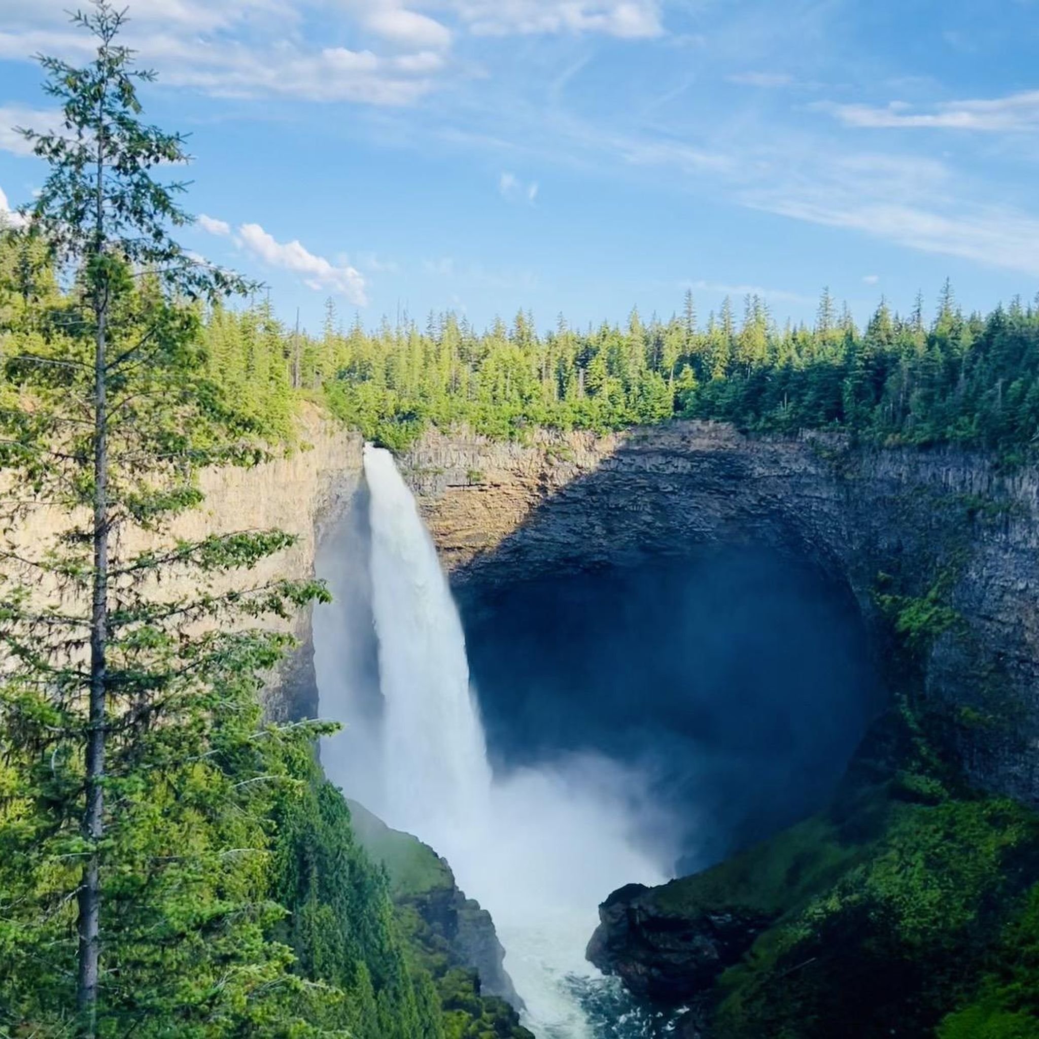
At over 140 metres tall, it's easy to see why Helmcken Falls was one of the main reasons for the formation of Wells Gray Provincial Park. While the spectacular waterfall is a main draw during the busy summer season, the area is also popular with ice climbers during winter and the falls are known as the "Yosemite of ice climbing".
1
0

A tough climb, but really cool.
3
0
So incredibly cool! You don't want to miss this.
3
0


From the Dawson Falls parking lot, a trail along the Murtle River takes you to the Falls in about 10 minutes. About two-thirds of the way, there is an excellent viewing point for the Falls. The water of the Murtle River plunges about 18 meters down a step at Dawson Falls. If you're lucky, you can see a rainbow below the Dawson Falls. Opposite is another observation point; it can be reached from the Pyramid Campground. In addition to Dawson Falls, there are six other waterfalls along the Murtle River in Wells Gray Park. (Visit June 3, 2018) https://www.worldwaterfalldatabase.com/waterfall/Dawson-Falls-2305 https://en.wikipedia.org/wiki/Dawson_Falls
2
0
Spahats Creek flows west from the Trophy Mountains, crossing the area's basalt formation. Upstream of Spahats Creek Falls, the creek has carved itself into a 23-meter-deep gorge and then plunges over the waterfall 61 meters into a massive canyon, emptying into the Clearwater River a few hundred meters later. The canyon is the result of glacial meltwater that flowed over the edge of the Clearwater Valley about 11,000 years ago. After the Ice Age, the stream receded into the comparatively small Spahats Creek. Spahats Creek was once known as Bear Creek. Spahats is a native word for bear. (Visit June 3, 2018) https://www.worldwaterfalldatabase.com/waterfall/Spahats-Creek-Falls-2293
3
0
It is possible to walk behind the waterfall to the opposite side of the creek without having to wade through the water. However, you will be splashed by the spray from the Falls. (Visit June 3, 2018)
3
0
Frequently Asked Questions
What natural features can I see in Wells Gray Country?
Wells Gray Country, often called "Waterfall Park," is renowned for its diverse natural landscape. You can explore numerous waterfalls, pristine lakes, and unique geological formations. Key features include powerful cascades like Helmcken Falls and Dawson Falls, as well as the expansive Clearwater and Azure Lakes. The region also showcases its volcanic past through lava beds and distinctive canyons.
Are there family-friendly natural monuments in Wells Gray Country?
Yes, several natural monuments in Wells Gray Country are suitable for families. Spahats Creek Falls offers an easy walk from the parking lot to a viewpoint, making it accessible for most. Dawson Falls is also considered family-friendly, with a relatively short and well-maintained trail to the viewing area. These spots provide impressive natural beauty without requiring strenuous effort.
What is the best time to visit the natural monuments in Wells Gray Country?
The best time to visit depends on what you wish to experience. Summer (early summer for the first bloom) is ideal for hiking through the vibrant Trophy Mountain Flower Meadows. Waterfalls are powerful during spring and early summer due to snowmelt. In winter, Helmcken Falls is particularly dramatic, forming an immense snow cone that can reach up to 50 meters in height.
Can I walk behind any waterfalls in Wells Gray Country?
Yes, you can experience the unique opportunity to walk behind Moul Falls. This 35-meter waterfall allows visitors to venture behind the curtain of water during certain times of the year, offering an immersive and memorable experience.
Are there hiking trails near the natural monuments in Wells Gray Country?
Absolutely. Wells Gray Country offers numerous hiking opportunities near its natural monuments. For example, you can find easy trails like the Moul Falls loop or the Dawson Falls loop. More moderate options include the Murtle River Bridge – Helmcken Falls loop. You can explore various routes in the Waterfall hikes around Area A (Wells Gray Country) guide or the general Hiking around Area A (Wells Gray Country) guide.
What unique geological formations can I explore in Wells Gray Country?
Wells Gray Country is rich in geological history, primarily shaped by its volcanic past. You can observe ancient lava flows at Dawson Falls, where the Murtle River drops over 200,000-year-old basalt. Spahats Falls plunges through volcanic rock, creating a unique keyhole-like formation. The entire region features extinct volcanoes, lava beds, and canyons carved by glacial meltwater.
What outdoor activities can I do near the natural monuments in Wells Gray Country?
Beyond visiting the monuments themselves, Wells Gray Country offers a wide range of outdoor activities. The Clearwater and Azure Lakes are renowned for canoeing, kayaking, stand-up paddleboarding, and boating. Hiking is popular, with trails ranging from easy to moderate, as detailed in guides like Hiking around Area A (Wells Gray Country). You can also find running trails, such as those listed in the Running Trails around Area A (Wells Gray Country) guide.
What wildlife can I expect to see near the natural monuments?
Wells Gray Provincial Park is a haven for diverse wildlife. Visitors often spot black bears, grizzly bears, moose, deer, and caribou. Birdwatchers can look out for eagles and various other species. The powerful whitewater rapids at Bailey's Chute on the Clearwater River are a notable spot in the fall, as salmon attempt to leap upstream, attracting bears.
Are there any natural monuments with impressive height or width?
Yes, Wells Gray Country boasts several impressive waterfalls. Helmcken Falls is particularly notable, plunging 141 meters (463 feet) and ranking as the fourth-highest waterfall in Canada. Dawson Falls, sometimes called "Mini Niagara," is impressive for its width, spanning 90 meters (295 feet) across.
What do visitors enjoy most about the natural monuments in Wells Gray Country?
Visitors frequently express awe at the sheer power and beauty of the waterfalls, particularly Helmcken Falls. The unique opportunity to walk behind Moul Falls is also a highlight for many. The well-maintained trails and panoramic views, especially at Dawson Falls, are often praised. The overall sense of wilderness and the chance for immersive nature experiences, such as canoeing on Clearwater and Azure Lakes, are highly valued.
Are permits or entrance fees required to visit the natural monuments in Wells Gray Country?
Wells Gray Provincial Park, which encompasses many of these natural monuments, generally does not require entrance fees for day use. However, specific activities like camping or backcountry use may require permits or fees. It's always advisable to check the official BC Parks website for the most current information regarding permits and regulations before your visit.
Most popular routes around Area A (Wells Gray Country)
Most popular attractions around Area A (Wells Gray Country)

Get inspired with the komoot mobile app


Explore more
Extend your search for the best caves by checking out these guides of the top ones around Area A (Wells Gray Country):
