The best walks and hikes around Paroisse de Carleton
4.9
(10)
116
hikers
7
hikes
Hiking around Paroisse de Carleton offers a selection of trails primarily located within Kouchibouguac National Park. The area features varied terrain, including coastal paths and routes along river estuaries. Hikers can explore paths that traverse low-lying areas with minimal elevation changes. The landscape is characterized by its proximity to water bodies and natural park environments.
Best hiking trails around Paroisse de Carleton
- The most popular hiking route is Claire Fontaine Trail loop — Kouchibouguac National Park, an easy 1.9…
Last updated: July 2, 2026
5.0
(1)
40
hikers
1.93km
00:29
0m
0m
Easy hike. Great for any fitness level. Easily-accessible paths. Suitable for all skill levels.
5.0
(1)
11
hikers
3.01km
00:46
10m
10m
Easy hike. Great for any fitness level. Easily-accessible paths. Suitable for all skill levels.

Sign up for free
1
hikers
17.5km
04:27
40m
40m
Moderate hike. Good fitness required. Easily-accessible paths. Suitable for all skill levels.
5.0
(4)
26
hikers
6.86km
01:44
10m
10m
Easy hike. Great for any fitness level. Easily-accessible paths. Suitable for all skill levels.
5.0
(1)
13
hikers
Moderate hike. Good fitness required. Easily-accessible paths. Suitable for all skill levels.
Get access to more routes and recommendations from other explorers.
Sign up for free
Already have an account?
Our route recommendations are based on thousands of hikes, rides, and runs completed by other people on komoot.
Start today with a free account
Your next adventure awaits.
Login or Signup
Popular around Paroisse de Carleton
Tips from the Community

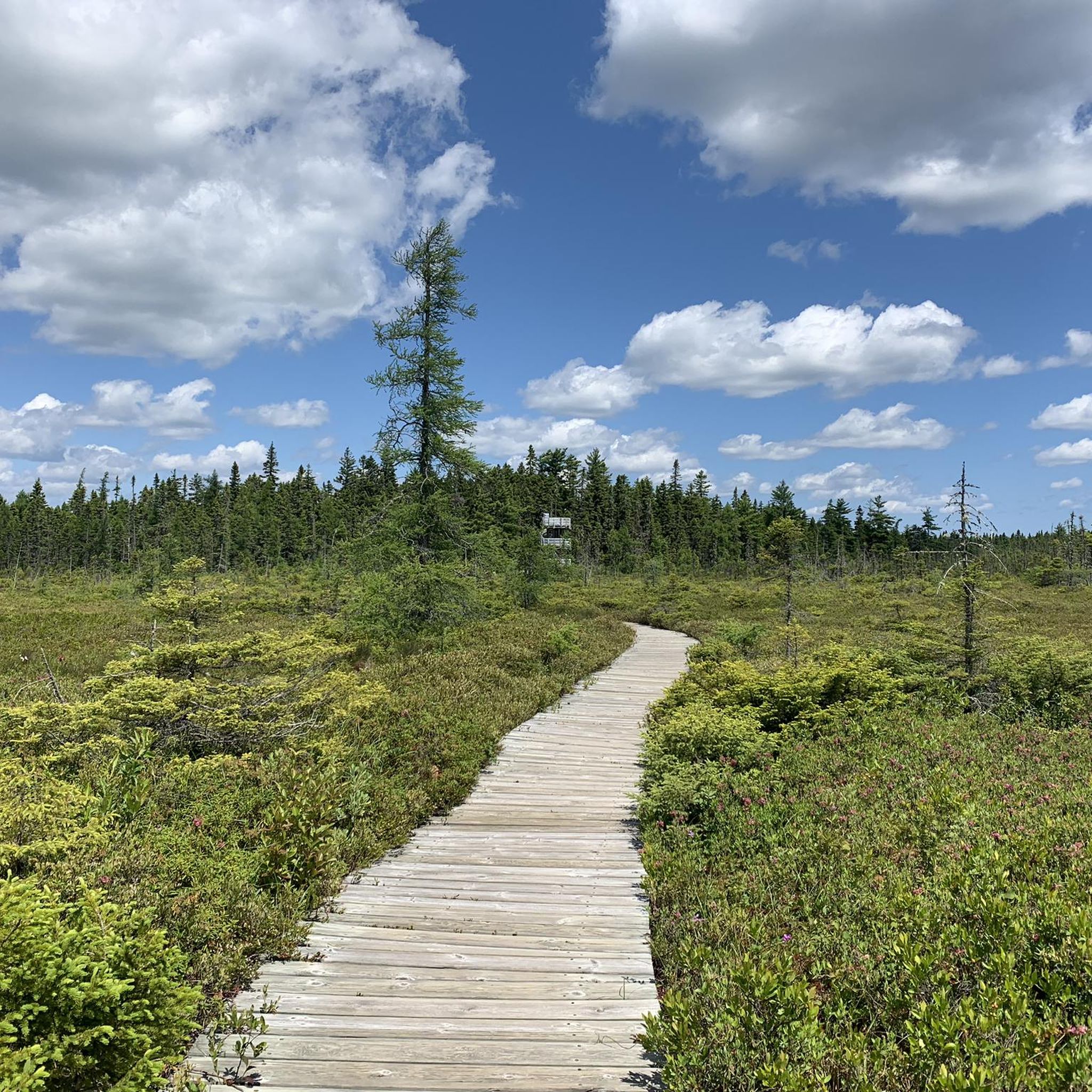
About 400 metres in along the Bog Trail, you will reach this six-metre observation tower. The top of the tower is accessible via a spiral staircase and provides some great views over the bog and some informational signs.
0
0
After circling around from the parking area, you will find the Bog Trailhead clearly marked with a sign and entrance to a packed gravel trail that starts out in a wooded area. Gradually, the trail opens up to a boardwalk with views of the bog and informational signs about the habitat itself.
0
0

The Black River is a slow-moving, tannin-rich river bordered by forest, wetlands, and pockets of salt marshes. The river is home to ducks, herons, and other birds that feed along its edges, especially during migration seasons. Its banks are peaceful and shaded, giving visitors a relaxing body of water to take in and enjoy.
0
0
The Claire-Fontaine Trail is a short loop that takes hikers through forest and wetlands, following Rankin Brook, the Black River, and a nearby lagoon. In the fall, the aspen and other mature trees change color, and there is more bird activity. Part of the loop traces the old community of Claire-Fontaine, built by Europeans in the late 1700s.
0
0
Rankin Brook is a small, peaceful river that offers great viewpoints along the southern section of the Claire-Fontaine Trail. It flows through the forest, creating pockets of cool, damp mini-climates along the loop. Rankin Brook eventually flows into the nearby Black River and lagoon system, so its water levels can fluctuate with weather.
0
0

Major Kollock Creek Trail is a forest singletrack linking the Petit-Larg campsite area with the Major Kollock Creek parking lot. The route follows mixed woodland with short rises and boardwalk crossings over wetter sections near the creek. It’s suitable for both hiking and mountain biking, with mostly narrow trail tread and a few roots in places. Expect a quiet forest setting, occasional views of the creek, and links to wider Kouchibouguac trail networks. Watch out for bikers along the singletrack sections, especially where visibility is lower.
0
0
Kouchibouguac’s beach sits on a barrier island reached by designated access paths. The shoreline is long and open, with firm sand and wide tidal zones. It’s suitable for walking and running, and in calm weather you’ll see uninterrupted views along the Gulf of St. Lawrence. The dunes and protected piping plover habitat nearby are signed, so stay on marked paths when connecting the beach to your route.
0
0
Frequently Asked Questions
What types of landscapes can I expect to see while hiking in Paroisse de Carleton?
Hiking in Paroisse de Carleton offers a diverse range of landscapes. You'll find coastal paths, routes along river estuaries, and trails within national park environments. The region is characterized by its proximity to water bodies and features low-lying areas with minimal elevation changes, particularly within Kouchibouguac National Park. If you venture towards Carleton-sur-Mer, the Parc régional du Mont-Saint-Joseph provides trails with breathtaking views of the sea and mountains, including ridges, valleys, streams, and majestic waterfalls.
Are there any easy hiking trails suitable for beginners or a relaxed walk?
Yes, Paroisse de Carleton has several easy trails. A popular choice is the Claire Fontaine Trail loop — Kouchibouguac National Park, which is 1.9 miles (3.0 km) long and takes about 45 minutes to complete with minimal elevation gain. Another easy option is the Kellys Beach loop from Kouchibouguac National Park of Canada, a 4.3 miles (6.9 km) coastal path.
Where can I find trails with panoramic views in the region?
For stunning panoramic views, head to the Parc régional du Mont-Saint-Joseph near Carleton-sur-Mer. From the summit of Mont-Saint-Joseph, at an altitude of 582 meters, there's a large belvedere offering breathtaking views of Baie-des-Chaleurs and the village of Carleton-sur-Mer. The trails within this park are known for providing excellent vistas of both the sea and mountains.
Are there any longer, more challenging hikes available?
Yes, for those seeking a longer experience, the Major Kollock Creek Trail loop — Kouchibouguac National Park is a moderate 10.9 miles (17.5 km) path. Additionally, the Kouchibouguac River Estuary loop from Kouchibouguac National Park of Canada offers a moderate 15.1 km (9.4 miles) hike through the park's natural environment.
What do other hikers say about the trails in Paroisse de Carleton?
The hiking routes in Paroisse de Carleton are highly rated by the komoot community, with an average score of 4.8 stars from over 9 reviews. Hikers often praise the varied terrain, from coastal paths to river estuary routes, and the well-maintained trails within Kouchibouguac National Park.
Are there any circular hiking routes in Paroisse de Carleton?
Yes, several circular routes are available. The Claire Fontaine Trail loop — Kouchibouguac National Park is an easy 1.9-mile loop. For a moderate option, consider the Major Kollock Creek Trail loop — Kouchibouguac National Park, which covers 10.9 miles. Another popular circular path is the Kellys Beach loop from Kouchibouguac National Park of Canada.
When is the best time of year to go hiking in Paroisse de Carleton?
The Parc régional du Mont-Saint-Joseph, a significant hiking area near Carleton-sur-Mer, is open annually from June 1 to November 1. This period generally offers favorable weather conditions for exploring the trails and enjoying the region's natural beauty, including its diverse landscapes and waterfalls.
Are there any trails that feature waterfalls?
Yes, if you explore the Parc régional du Mont-Saint-Joseph near Carleton-sur-Mer, you can venture through valleys that feature streams and majestic waterfalls. These natural features add a scenic element to the hiking experience in that area.
What historical or cultural sites can be found along the trails?
Mont-Saint-Joseph, within the Parc régional du Mont-Saint-Joseph, holds historical and cultural significance. It has been a Catholic pilgrimage site since the 19th century and features a chapel built in 1935. A Visitor Centre within the park also offers insights into the history of the Mi'gmaq Nation, who considered Mont-Saint-Joseph an important gathering place.
How many hiking trails are there in Paroisse de Carleton?
There are at least 6 recorded hiking routes in Paroisse de Carleton, ranging from easy to moderate difficulty. These trails are primarily located within Kouchibouguac National Park and offer various lengths and experiences.
Are the trails in Paroisse de Carleton suitable for families?
Yes, many trails are suitable for families, especially the easier routes. The Claire Fontaine Trail loop — Kouchibouguac National Park is an easy, shorter option perfect for a family outing. The Parc régional du Mont-Saint-Joseph also offers trails suitable for all skill levels, making it a good choice for families.
Most popular routes around Paroisse de Carleton
Most popular attractions around Paroisse de Carleton

Get inspired with the komoot mobile app


Explore more
Browse the best Hikes in other regions.
