The best walks and hikes around Spallumcheen
4.2
(20)
231
hikers
14
hikes
Hiking around Spallumcheen offers diverse outdoor experiences across its picturesque rural landscape. The region is characterized by rolling hills, panoramic valley views, and a mix of farmlands, lakes, and wetlands. Hikers can explore dense cedar forests, observe diverse flora, and enjoy views of distant mountains. This area provides a network of trails suitable for various skill levels.
Best hiking trails around Spallumcheen
- The most popular hiking route is Mount Rose Swanson Trail: Aspen & Douglas Fir loop — Spallumcheen Valley…
Last updated: October 18, 2026
4.2
(5)
40
hikers
5.85km
01:40
140m
140m
Easy hike. Great for any fitness level. Easily-accessible paths. Suitable for all skill levels.
5.0
(1)
19
hikers
4.81km
01:29
170m
170m
Easy hike. Great for any fitness level. Easily-accessible paths. Suitable for all skill levels.

4.0
(1)
17
hikers
8.14km
02:35
310m
310m
Moderate hike. Good fitness required. Easily-accessible paths. Suitable for all skill levels.
17
hikers
6.94km
01:58
150m
150m
Easy hike. Great for any fitness level. Easily-accessible paths. Suitable for all skill levels.
12
hikers
10.3km
02:42
80m
80m
Moderate hike. Good fitness required. Easily-accessible paths. Suitable for all skill levels.
Get access to more routes and recommendations from other explorers.
Already have an account?
Our route recommendations are based on thousands of hikes, rides, and runs completed by other people on komoot.
Start today with a free account
Your next adventure awaits.
Popular around Spallumcheen

Tips from the Community

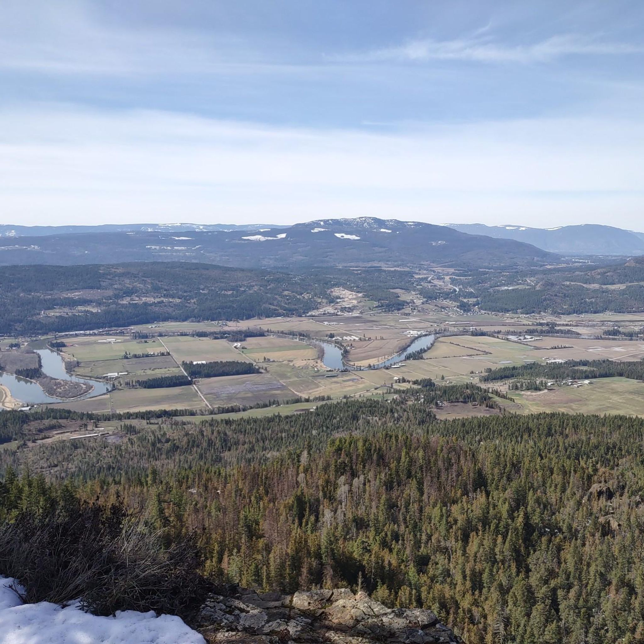
This viewpoint sits just below the summit of Mount Rose Swanson, giving you great views over the surrounding area. It's one of many viewpoints along the Jackpine Trail, though it's up to you to decide which one is your favourite.
0
0

The trail climbs steadily at a moderate grade before it turns west toward the overlooks and climbs Mount Rose. You descend a little between here and the tower lookout if you continue on the Centennial Trail.
0
0
There is a large crushed gravel lot at the trailhead, and the drive in is quite accessible. The trails here are a mix of moderate difficulty paths that take you up to panoramic views of the countryside. There is an outhouse at the overlook when you get there.
0
0

The Grey Canal Trail Turtle Mountain section is one of eight sections of the Grey Canal Trail. This section stands as a scenic portion with sweeping views but is also quite exposed without tree coverage. The trail follows British Columbia's longest irrigation channel that was built in the beginning of the 1900s.
0
0
This viewpoint can be reached via a short spur trail and has elevated views of the town of Vernon below. There are a few spur trails, all varying in length, that lead to different views along the Grey Canal Trail Turtle Mountain section, so keep navigation handy to not get turned around.
0
0
The parking area on Blue Jay Road provides access to the Turtle Mountain section of the Grey Canal Trail. This parking area is a dirt lot with no amenities.
0
0

The Mount Swanson Trails system form a lovely loop of pathways through a mix of shaded forest and open views across the Spallumcheen Valley above Armstrong, with Aspen and Centennial as the main circuit. Together, they make a 4.8 kilometre loop, with side trails leading to rocky viewpoints and summit bluffs. Junctions are clearly marked, making it the perfect place to enjoy a short hike or a half-day outing.
0
0
The Tower Lookout offers one of the clearest panoramic views of Mount Rose Swanson, with a wide-open vista over the valley. From here, you’ll see rolling farmland, forested hills, and distant lakes with minimal tree obstruction. It’s a rewarding climb through shaded forest to a breezy, high-elevation bluff that feels like a true summit.
0
0
Frequently Asked Questions
What types of landscapes can I expect to see while hiking in Spallumcheen?
Spallumcheen offers a diverse range of landscapes, from picturesque rolling hills and expansive farmlands to dense cedar forests and wetlands. You'll also find panoramic views of the Spallumcheen Valley, distant Monashee Mountains, and glimpses of lakes like Otter Lake and Swan Lake.
Are there hiking trails suitable for families with children?
Yes, Spallumcheen has several family-friendly options. The trail system at Mount Rose Swanson, located near Armstrong, is suitable for all levels, including families, offering diverse terrain and scenic views. The Thomas Hayes Ecological Reserve also features easy trails like the 4.3km Coyote Loop, which are great for a leisurely family walk, though dogs are not permitted there.
Can I bring my dog on the hiking trails in Spallumcheen?
Many trails in Spallumcheen are dog-friendly, allowing you to enjoy the outdoors with your pet. However, please note that dogs are not permitted on the trails within the Thomas Hayes Ecological Reserve to protect the local wildlife.
What are some notable viewpoints or landmarks to look for on the trails?
Hikers can enjoy stunning vistas from various points. On the Mount Rose Swanson Trail, Turner's Terrace and the radio tower lookout offer panoramic views of the Spallumcheen Valley, Armstrong, and surrounding lakes. The Grey Canal Trail: Bella Vista also provides expansive views across the valley. For birdwatching, the Otter Lake Lookout offers views over the wetlands.
Are there any easy, short hikes for a quick outing?
Yes, for a quick and easy outing, consider the BX Creek Trail, which is about 5.9 km and takes around 1 hour 40 minutes through forested areas. The Mount Rose Swanson Trail: Aspen & Douglas Fir loop is another easy option at 5.7 km, typically completed in under two hours.
What is the best time of year to go hiking in Spallumcheen?
Spring is particularly beautiful for hiking in Spallumcheen, as the trails come alive with wildflowers such as chocolate lilies, wild rose, and Indian paintbrush. The pleasant temperatures of spring and fall generally offer the most comfortable hiking conditions.
Are there any loop trails available in the area?
Yes, loop trails are a popular option for hikers. The Mount Rose Swanson Trail: Aspen & Douglas Fir loop is a great example, offering a circular route with diverse scenery. Additionally, the Thomas Hayes Ecological Reserve features the 4.3km Coyote Loop, which connects to shorter loops like White Tail Wander and Chipmunk Cutoff.
What do other hikers say about the trails in Spallumcheen?
The hiking routes in Spallumcheen are highly rated by the komoot community, with an average score of 5.0 stars. Hikers often praise the diverse terrain, the stunning valley views, and the well-maintained paths that cater to various skill levels.
Are there any longer, more challenging hikes for experienced hikers?
For those seeking a longer, moderate challenge, the View from Enderby Cliffs loop from Enderby is a substantial hike at nearly 13 km with significant elevation gain, offering rewarding views. Another moderate option is the Silver Star Mountain loop from Silver Star Mountain Resort, which covers over 11 km.
Where can I find parking for the trailheads?
Specific parking information varies by trailhead. For popular areas like Mount Rose Swanson, designated parking lots are available. For other trails, roadside parking may be an option. It's always recommended to check local signage for parking regulations before you go.
Are there opportunities for birdwatching while hiking?
Absolutely. The wetlands surrounding Otter Lake, particularly near the Thomas Hayes Ecological Reserve, are noted for excellent birdwatching opportunities. The Otter Lake Lookout is a favorite spot for locals to observe various bird species.
Beyond dedicated trails, are there other places to walk in the area?
Yes, the Armstrong Spallumcheen area boasts over 200 kilometers of quiet, paved rural roads. These roads wind through the scenic countryside, offering additional opportunities for leisurely walks and enjoying the rural charm and panoramic views.
Most popular routes around Spallumcheen
Most popular attractions around Spallumcheen

Get inspired with the komoot mobile app


Explore more
Browse the best Hikes in other regions.
