Easy hikes and walks around Estany de la Colomina
4.7
(787)
6,859
hikers
88
hikes
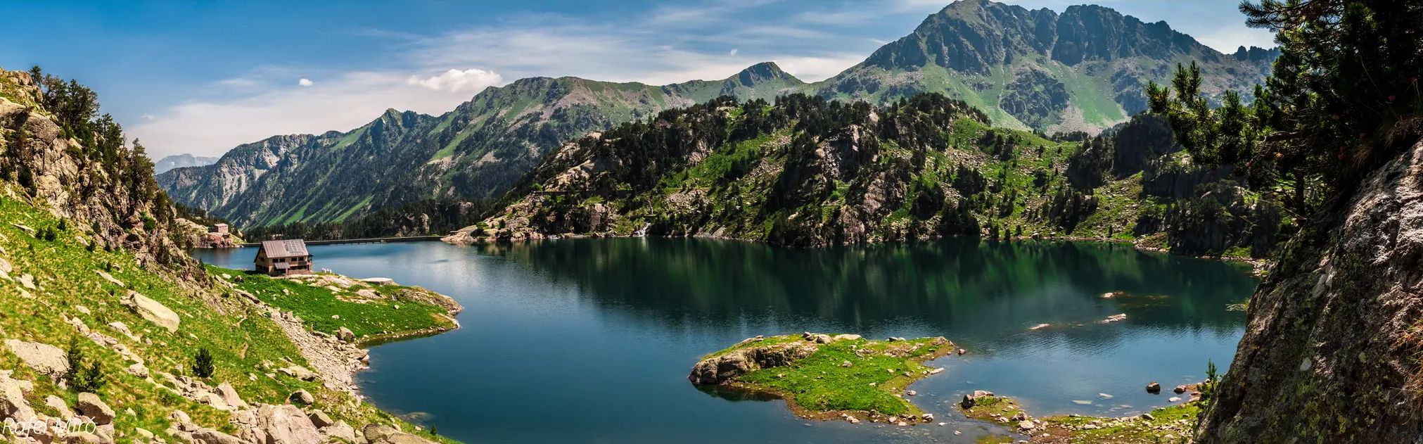
Hiking around Estany de la Colomina offers access to a high-mountain landscape shaped by glacial activity, featuring numerous lakes and dramatic peaks within the Catalan Pyrenees. The region is characterized by granitic and slate formations, U-shaped valleys, and diverse vegetation zones ranging from pine forests to alpine pastures. Hikers can explore a network of trails amidst these natural features, including several interconnected glacial lakes. This area provides a range of easy hiking trails suitable for various experience levels.
Best easy hiking trails around Estany de la Colomina
- The most popular easy hiking route is Vía Verde de La Vall Fosca – Estany Gento loop from Estany Gento, a 2.1 miles (3.4 km) trail that takes 57 minutes to complete. This route follows a greenway, offering accessible paths around Estany Gento.
- Another top favourite among local hikers is Hiking loop from Sant Vicenç, an easy 2.2 miles (3.6 km) path. This trail features varied terrain with views of the surrounding Pyrenean foothills.
- Local hikers also love the Hiking loop from la Central de Cabdella, a 1.8 miles (3.0 km) trail leading through forested areas and open landscapes, often completed in about 1 hour 6 minutes.
- Hiking around Estany de la Colomina is defined by glacial lakes, high-altitude peaks, and diverse forest and alpine vegetation. The network offers options for different ability levels, with several easy routes available.
- The routes in Estany de la Colomina are highly rated by the komoot community with an average score of 4.7 stars from over 700 reviews. More than 6,500 hikers have used komoot to explore Estany de la Colomina's varied terrain.
Last updated: July 1, 2026
5.0
(2)
6
hikers
3.24km
00:55
70m
70m
Easy hike. Great for any fitness level. Easily-accessible paths. Suitable for all skill levels.
3
hikers
3.59km
01:14
170m
180m
Easy hike. Great for any fitness level. Easily-accessible paths. Suitable for all skill levels.

Sign up for free
3
hikers
3.06km
01:08
190m
190m
Easy hike. Great for any fitness level. Easily-accessible paths. Suitable for all skill levels.
4.0
(1)
5
hikers
4.65km
01:19
110m
110m
Hike the easy 2.9-mile Espot to Sant Maurici Trail in Aigüestortes National Park, featuring the iconic Estany de Sant Maurici lake.
4.1
(16)
44
hikers
4.23km
01:17
140m
140m
Easy hike. Great for any fitness level. Easily-accessible paths. Suitable for all skill levels.
Get access to more routes and recommendations from other explorers.
Sign up for free
Already have an account?
Our route recommendations are based on thousands of hikes, rides, and runs completed by other people on komoot.
Start today with a free account
Your next adventure awaits.
Login or Signup
Popular around Estany de la Colomina
Other adventures around Estany de la Colomina

Tips from the Community

Old Roman bridge in Espot
0
0

especially in the evening hours surrounded by many butterflies
0
0
We were here in August and saw a variety of butterflies, especially in the evening hours
0
0

Attention! This cable car is not suitable for people with walking difficulties as there are about 80 steep steps to climb!
0
0

A charming town in the heart of the Catalan Pyrenees known for its natural beauty. When summer arrives they become a paradise for trail running and hiking.
2
0

The cable car takes you from about 1700 to 2100 m and thus to a good starting point in the southern Aigües Tortes area. More accessible and less crowded than from the northeast via the Estany de Sant Maurici.
0
0

Nice start of the route.
1
0
Frequently Asked Questions
How many easy hiking trails are available around Estany de la Colomina?
The Estany de la Colomina area offers 5 easy hiking trails, perfect for those looking for gentle walks amidst the stunning Pyrenean landscape. In total, there are 87 hiking routes of varying difficulty.
What kind of natural features can I expect to see on easy hikes in this region?
Easy hikes around Estany de la Colomina will immerse you in a glacial landscape featuring numerous interconnected lakes with striking blue and green hues. You'll encounter U-shaped valleys, dramatic peaks like Pic de Saburó, and diverse vegetation ranging from black pine and fir forests to alpine pastures with resilient flora like gentians and rhododendrons. Many routes also feature beautiful waterfalls.
Are there any family-friendly easy hiking routes?
Yes, several easy routes are suitable for families. The Vía Verde de La Vall Fosca – Estany Gento loop from Estany Gento is a particularly good option, following a greenway that offers accessible paths around Estany Gento. The teleférico to Estany Gento can also reduce initial elevation gain, making it easier to access the higher areas.
Can I bring my dog on the easy trails around Estany de la Colomina?
While the Aigüestortes i Estany de Sant Maurici National Park has specific regulations regarding dogs, generally, dogs are permitted on trails in the peripheral areas and on leashes. It's always best to check local signage or the park's official guidelines for the specific trail you plan to hike to ensure compliance.
What is the best time of year for easy hiking in Estany de la Colomina?
The best time for easy hiking in Estany de la Colomina is typically during the warmer months, from late spring to early autumn (June to September). During this period, the snow has usually melted from lower elevations, trails are clear, and the alpine flora is in bloom. The teleférico to Estany Gento also operates during the summer, providing easier access.
Are there any circular easy walks available?
Yes, there are several circular easy walks. A popular choice is the Vía Verde de La Vall Fosca – Estany Gento loop from Estany Gento, which offers a pleasant round trip. Another option is the Hiking loop from Sant Vicenç, providing varied terrain and views.
What are some notable points of interest or attractions along the easy hiking trails?
Beyond the stunning lakes themselves, you might discover remnants of former mining activity, such as old abandoned rails, adding a historical dimension to your walk. The area is also rich in diverse wildlife, including Pyrenean chamois and marmots, and offers opportunities for birdwatching. The Refugi Colomina by Estany de la Colomina is a significant landmark and a great spot for panoramic views.
How do other hikers rate the easy trails in Estany de la Colomina?
The easy trails in Estany de la Colomina are highly regarded by the komoot community, with an average rating of 4.7 stars from over 700 reviews. Hikers often praise the stunning glacial scenery, the well-maintained paths, and the accessibility of these routes for various fitness levels.
Is public transport available to reach the starting points of easy hikes?
Access to the Vall Fosca, which leads to Estany Gento (a common starting point for hikes to Colomina), can be challenging without a private vehicle. However, during peak season, there might be local bus services or taxis connecting villages in the valley. It's advisable to check specific schedules for public transport options to the Vall Fosca and Estany Gento before planning your trip.
Where can I park for easy hikes around Estany de la Colomina?
Parking is typically available near key access points such as Estany Gento, which can be reached by road. From Estany Gento, you can either hike or take the teleférico further into the mountains. Other starting points like Sant Vicenç or la Central de Cabdella also have designated parking areas, though availability can vary, especially during busy periods.
Are there any easy trails that offer views of multiple lakes?
Yes, the region is known for its interconnected glacial lakes. While specific easy routes might focus on one or two, many trails offer glimpses of several lakes. For instance, routes starting from Estany Gento can lead you towards Estany de la Colomina, and from there, you can often see Estany Frescau and Estany de Mar, which are just a short walk away from Refugi Colomina.
What is the terrain like on easy hiking trails in Estany de la Colomina?
The terrain on easy hiking trails around Estany de la Colomina is generally well-maintained and manageable. You can expect paths that traverse forested areas, open alpine meadows, and sections along the shores of glacial lakes. While some routes might have gentle ascents and descents, they are designed to be accessible, avoiding steep or overly rocky sections.
Most popular routes around Estany de la Colomina

Get inspired with the komoot mobile app


Explore more
Browse the best Hikes in other regions.
