Easy hikes and walks in Pinckney State Recreation Area
4.7
(33)
295
hikers
31
hikes
Easy hiking trails in Pinckney State Recreation Area traverse a diverse landscape shaped by glacial history. The area features rolling hills, serene lakes, and lush forests, primarily composed of oak woodlands, wetlands, and meadows. This extensive network of routes provides varied terrain for hikers, showcasing the region's natural features.
Best easy hiking trails in Pinckney State Recreation Area
- The most popular easy hiking route is Waterloo-Pinckney Trail: Park Lyndon Loop, a 4.5 miles (7.3 km) trail that takes 1 hour 57 minutes to complete. This path offers views of glacial features and varied woodland.
- Another top favourite among local hikers is Silver Lake to Blind Lake Trail, an easy 4.2 miles (6.8 km) path. This route leads through forested areas and past lakes, connecting to a rustic campground.
- Local hikers also love the Potawatomi Trail and Silver Lake Loop, a 4.2 miles (6.8 km) trail leading through woodlands and along Silver Lake, often completed in about 1 hour 45 minutes.
- Hiking in Pinckney State Recreation Area is defined by rolling hills, serene lakes, and lush forests, offering a network of routes for different ability levels.
- The routes in Pinckney State Recreation Area are highly rated by the komoot community with an average score of 4.9 stars from more than 30 reviews. More than 350 hikers have used komoot to explore Pinckney State Recreation Area's varied terrain.
Last updated: July 8, 2026
15
hikers
6.80km
01:47
60m
60m
The Silver Lake to Blind Lake Trail offers an easy hiking experience, covering 4.2 miles (6.8 km) with a gentle elevation gain of 194 feet (59 metres). You can expect to complete this route in about 1 hour and 47 minutes, immersing yourself in a varied landscape. As you hike, the path meanders through dense wooded sections, revealing glimpses of several serene lakes and ponds. Look for the narrow boardwalks that guide you over marshy areas, including the distinctive Wetland Boardwalk, and keep an eye out for the scenic Dead Lake Overlook.
To begin your adventure, head to the Silver Lake day-use area where ample parking is available. This location also provides convenient amenities such as a swimming area and picnic tables, perfect for before or after your hike. While the trail is generally easy, be prepared for some uneven terrain and tree roots, especially in wooded sections. Wearing appropriate footwear is recommended to comfortably navigate the varied surfaces, which include smoothed-over rocks and boardwalks.
This route is nestled within Michigan's Pinckney State Recreation Area, a region known for its diverse natural beauty. The trail showcases a dynamic environment, from vibrant autumn forests to spring wildflowers blooming in the wetlands. It provides a wonderful opportunity to connect with nature and observe the local ecosystem, making it a notable option for a refreshing outdoor escape in the area.
2
hikers
6.76km
01:45
40m
40m
Embark on the Potawatomi Trail and Silver Lake Loop for an easy hike through diverse scenery. This route covers 4.2 miles (6.8 km) with a gentle elevation gain of 129 feet (39 metres), taking about 1 hours and 45 minutes to complete. As you hike, you will experience rolling glacial hills, woodlands, and wetland areas, with picturesque views of Silver Lake and charming wooden bridges crossing streams.
To plan your visit, head to the trailhead conveniently located near the Silver Lake swimming access. You will find amenities like picnic areas and a bathhouse there. Parking is generally available at this spot, making it easy to begin your adventure. This area is quite popular, especially during the warmer months, so consider an early start.
This loop offers a wonderful taste of the natural beauty within the Pinckney Recreation Area. You can expect to see vibrant wildflowers in spring as you traverse the varied terrain, which includes unique glacial moraines. The trail provides a serene outdoor experience, showcasing the region's distinct ecosystem.

Sign up for free
2
hikers
7.28km
01:57
90m
80m
Explore the Waterloo-Pinckney Trail: Park Lyndon Loop, an easy hiking route covering 4.5 miles (7.3 km) with a gentle elevation gain of 298 feet (91 metres). This loop typically takes around 1 hour and 57 minutes to complete. You will wind through diverse landscapes, from wetlands with boardwalks to dense pine forests and open prairies, offering picturesque views of Lake Genevieve from a spur trail.
When planning your visit, note that the trails are generally well-marked with mile markers, making navigation straightforward. Leashed dogs are welcome on the route, so you can bring your furry companion along. Be aware that hunting is permitted in certain areas of the broader Waterloo-Pinckney Trail during established seasons, so check local regulations before you go.
This trail offers a glimpse into Michigan's natural beauty, shaped by ancient glaciers that created its rolling hills, kames, and kettles. As you hike, keep an eye out for local wildlife, including deer and groundhogs, which are often seen in these diverse habitats. The varied terrain provides a rich experience for those looking to connect with nature.
2
hikers
6.40km
01:45
90m
100m
The Stinchfield Woods from Toma Road offers an easy hiking experience through varied woodland. You will cover 4.0 miles (6.4 km) with a gentle elevation gain of 309 feet (94 metres), taking about 1 hour and 44 minutes to complete. Expect to wander through a mix of native hardwoods and conifer plantations, creating a changing landscape with the seasons. Keep an eye out for Peach Mountain, which is the highest point in Southeast Michigan, providing a notable feature along your journey. The route provides a pleasant outing for those looking for a relatively quick and accessible hike.
When planning your visit, be aware that trail markers can sometimes be scarce, so carrying a compass or using a GPS app is a good idea, especially if you are new to the area. The property is open to the public from dawn to dusk, allowing ample time for your hike. Dogs are welcome on the trails, but you must keep them on a leash at all times. Please note that bicycles are generally not permitted on these trails. Remember to wear sturdy shoes and bring enough food and water for your journey.
Stinchfield Woods is known for its expansive network of trails and diverse natural beauty, characterized by rolling hills and a blend of native and planted forests. The area features extensive plantings of red pine, white pine, and Douglas fir alongside oak-hickory forests. This creates a unique environment that changes visually throughout the year. The woods offer a chance to explore a significant natural area in Southeast Michigan, providing a peaceful escape into nature.
3.36km
00:53
20m
40m
Embark on an easy hike along the Potawatomi and Waterloo-Pinckney Trail, a pleasant 2.1 miles (3.4 km) route that takes about 52 minutes to complete. You will experience a gentle elevation gain of 65 feet (20 metres) as you wander through dense woodlands and past the serene Portage River. This trail offers a peaceful escape into nature, perfect for a quick outdoor outing.
When planning your visit, remember that parking is generally available at designated trailheads within the Pinckney State Recreation Area. The trails are typically well-marked, making navigation straightforward. While this specific route is short, be aware that other sections of the broader Potawatomi Trail can become muddy after rain, so consider waterproof footwear for comfort.
This area's landscape was shaped by ancient glaciers, resulting in its characteristic rolling hills and rich woodlands. As you hike, keep an eye out for local wildlife; deer, foxes, and various bird species are often seen here. The trail provides a wonderful opportunity to connect with the natural environment and observe the region's diverse ecosystem.
Get access to more routes and recommendations from other explorers.
Sign up for free
Already have an account?
Our route recommendations are based on thousands of hikes, rides, and runs completed by other people on komoot.
Start today with a free account
Your next adventure awaits.
Login or Signup
Popular around Pinckney State Recreation Area
Other adventures in Pinckney State Recreation Area

Tips from the Community

This trailhead sits beside Pickerel Lake, an 80-acre undeveloped lake in Pinckney Recreation Area. The lake is a serene retreat, ringed by unspoiled forest and wetlands, with no buildings or development along its shore. From here, hikers can step directly into wilderness, using the trailhead as both an access point for the Waterloo–Pinckney Trail and a gateway to quiet exploration around Pickerel Lake.
0
0
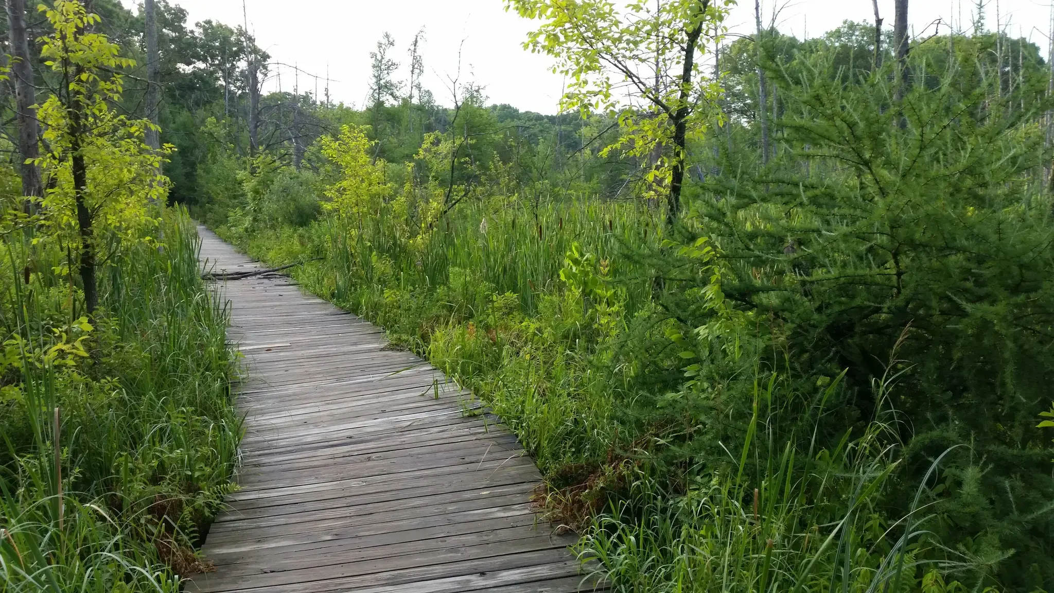
A raised wooden boardwalk carrying the Waterloo–Pinckney Trail across a marsh just west of Hankerd Road. This stretch offers a glimpse into Pinckney’s wetland habitat, where cattails, shrubs, and standing dead trees attract marsh birds and amphibians. It’s both a practical crossing and a scenic change of pace, immersing hikers in one of the park’s most vibrant ecosystems.
0
0
A 11,000-acre park known for its rolling forests, quiet inland lakes, and one of Michigan’s best networks of hiking and biking trails. The eastern half of the 34-mile Waterloo–Pinckney Trail runs through here, linking kettle lakes, ridges, and rustic campgrounds like Blind Lake. With its mix of loop trails, backpacking routes, and lake access, Pinckney is a hub for outdoor adventure and the perfect landscape to end a thru-hike.
0
0
Set about halfway along the 17-mile Potawatomi Trail loop in Pinckney Recreation Area, Blind Lake is a hike-in only campground with 10 rustic sites. Each site has a fire ring, with vault toilets and a hand pump for water nearby. Campers must check in at the park office on the day of arrival, and stays are limited to one night. Reservations are available online, but same-day arrivals are first-come, first-served.
0
0

This is a small river that connects Watson Lake and Halfmon Lake. There are some nice views of the water as you pass over the bridge here.
0
0

This is where the the Portage River separates Watson Lake and Halfmoon Lake. Both lakes as well as the river are known for great fishing.
0
0
Frequently Asked Questions
How many easy hiking trails are available in Pinckney State Recreation Area?
Pinckney State Recreation Area offers 14 easy hiking trails, providing a variety of options for a relaxed outdoor experience. In total, there are over 30 routes for different skill levels.
What kind of terrain can I expect on easy hikes in Pinckney State Recreation Area?
The easy hiking trails in Pinckney State Recreation Area traverse diverse landscapes shaped by glacial history. You'll find rolling hills, serene lakes, and lush forests, primarily composed of oak woodlands, wetlands, and meadows. The terrain is generally manageable, with moderate elevation changes, making it suitable for beginners and casual hikers.
Are there any easy loop trails in Pinckney State Recreation Area?
Yes, several easy loop trails are available. For example, the Potawatomi Trail and Silver Lake Loop is a 4.2-mile route that takes you through woodlands and along Silver Lake. Another popular option is the Waterloo-Pinckney Trail: Park Lyndon Loop, a 4.5-mile trail offering views of glacial features.
Can I bring my dog on the easy hiking trails?
Pinckney State Recreation Area is generally dog-friendly, but it's always best to check specific trail regulations. Dogs are typically allowed on trails if kept on a leash. Please ensure you clean up after your pet to maintain the natural beauty of the area.
Are the easy trails suitable for families with children?
Yes, the easy trails in Pinckney State Recreation Area are well-suited for families with children. The manageable distances and varied scenery, including lakes and forests, provide an engaging experience for all ages. Trails like the Potawatomi and Waterloo-Pinckney Trail offer shorter, less strenuous options.
What natural features can I see along the easy hiking trails?
The easy trails showcase the area's rich natural beauty, shaped by glacial history. You can expect to see rolling hills, lush oak forests, and serene lakes. Keep an eye out for wetlands, meadows, and diverse wildlife, including deer and various bird species. The Wetland Boardwalk along the Waterloo–Pinckney Trail offers an intimate view of the park's wetland habitat.
Where can I park when accessing easy trails in Pinckney State Recreation Area?
Pinckney State Recreation Area offers several day-use areas with parking, such as the Silver Lake and Halfmoon Lake units. These areas provide convenient access to many trails. The Mark Hoffman Trailhead is another access point for various routes.
What is the best time of year to go for an easy hike?
Spring, summer, and fall all offer excellent conditions for easy hikes in Pinckney State Recreation Area. Spring brings blooming wildflowers, summer provides lush greenery and opportunities for water activities, while fall showcases vibrant foliage. Each season offers a unique experience, though summer can be busy.
Are there any specific attractions or points of interest along the easy routes?
Yes, many easy routes pass by notable points of interest. You can explore the interconnected Chain of Lakes, including Silver Lake and Losee Lake. The Silver Lake to Blind Lake Trail connects to the rustic Blind Lake Walk-In Campground, offering a glimpse into backcountry camping.
What do other hikers say about the easy trails in Pinckney State Recreation Area?
The easy trails in Pinckney State Recreation Area are highly rated by the komoot community, with an average score of 4.9 stars from over 30 reviews. Reviewers often praise the quiet woodlands, well-maintained paths, and the scenic beauty of the lakes and glacial formations.
What is the typical length of an easy hiking trail in Pinckney State Recreation Area?
Easy hiking trails in Pinckney State Recreation Area typically range from 2 to 4.5 miles in length. For instance, the Potawatomi and Waterloo-Pinckney Trail is about 2.1 miles, while the Waterloo-Pinckney Trail: Park Lyndon Loop is 4.5 miles, offering options for various time commitments.
Is public transport available to reach Pinckney State Recreation Area?
Pinckney State Recreation Area is primarily accessed by car, as public transport options directly to the trailheads are limited. It is advisable to plan for private transportation to reach the park's various entry points and parking areas.
Are there any fees or permits required for hiking in Pinckney State Recreation Area?
As a Michigan State Recreation Area, a Recreation Passport is required for vehicle entry. This passport provides access to all Michigan state parks and recreation areas for the year. You can purchase it when renewing your license plate or at the park entrance.
Most popular routes in Pinckney State Recreation Area
Most popular attractions in Pinckney State Recreation Area

Get inspired with the komoot mobile app


Explore more
Browse the best Hikes in other regions.
