The best walks and hikes in Bash Bish Falls State Park
4.6
(25)
284
hikers
32
hikes
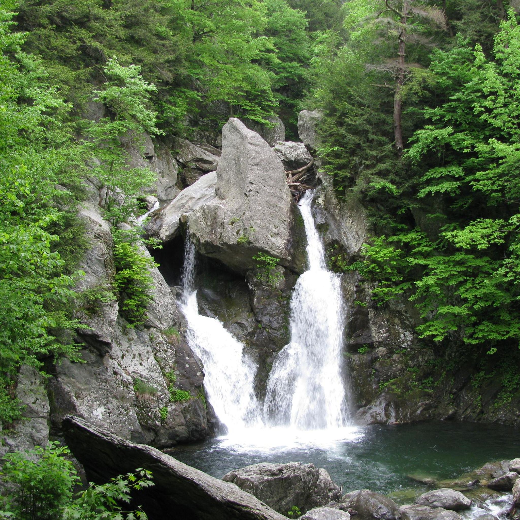
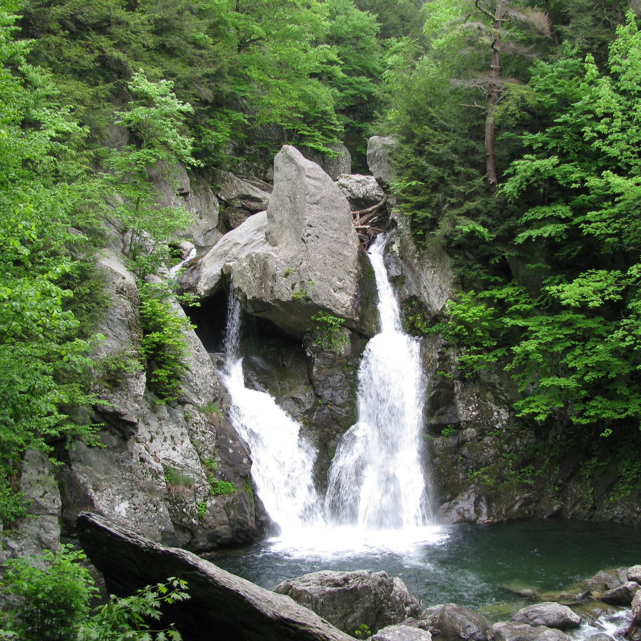
Hiking in Bash Bish Falls State Park offers diverse terrain within the Taconic Range, characterized by its hemlock-hardwood ravine forest and deep gorges. The park's central feature is Massachusetts' tallest single-drop waterfall, Bash Bish Falls, which plunges into an emerald pool. Trails navigate through varied landscapes, including slopes adorned with maple, oak, and beech trees. This region provides a blend of captivating scenery and natural features for hikers.
Best hiking trails in Bash Bish Falls State Park
- The most popular hiking route is Bash Bish Falls loop from Bash Bish Falls State Park, a 0.7 miles (1.1 km) trail that takes about 26 minutes to complete. This easy route leads directly to the park's iconic waterfall.
- Another top favourite among local hikers is Bash Bish Falls loop from Taconic State Park – Copake Falls Area, an easy 1.6 miles (2.5 km) path. This trail offers a gradual approach along Bash Bish Brook.
- Local hikers also love the Alander Mountain Summit via South Taconic Trail — Berkshire County, a 6.3 miles (10.2 km) trail leading through the Taconic Range, often completed in about 3 hours 21 minutes.
- Hiking in Bash Bish Falls State Park is defined by its dramatic waterfalls, hemlock-hardwood ravine forests, and varied terrain of the Taconic Range. The network offers options for different ability levels, from easy loops to more challenging ascents.
- The routes in Bash Bish Falls State Park are highly rated by the komoot community with an average score of 4.6 stars from over 20 reviews. More than 200 hikers have used komoot to explore Bash Bish Falls State Park's varied terrain.
Last updated: October 12, 2026
4.0
(1)
9
hikers
Easy hike. Great for any fitness level. Easily-accessible paths. Suitable for all skill levels.
3.5
(2)
9
hikers
8.76km
02:56
480m
260m
The Alander Mountain via South Taconic Trail offers a diverse hiking experience, starting in open fields before winding through dense forests. You will encounter creek crossings and sections that can be muddy, but the real journey begins as the trail steepens and becomes rockier, leading to the summit. From the grassy, scrub-oak-covered Alander Mountain Summit, you are rewarded with expansive 360-degree views stretching across the Catskill Mountains, Hudson Valley, and the Berkshires.
This moderate route covers 5.4 miles (8.8 km) with a substantial 1573 feet (479 metres) of elevation gain, typically taking around 2 hours and 56 minutes. Parking is available at the trailhead, but arriving early is recommended, especially during peak seasons. Be aware that timber rattlesnakes are known to inhabit the Taconic Range, particularly around Alander Mountain, so keep an eye out during warmer weather.
One unique aspect of this trail is that Alander Mountain sits directly on the border of Massachusetts and New York, meaning you will cross the state line multiple times. The route also connects to the longer South Taconic Trail, offering options for extended backpacking trips, including a popular link to Bash Bish Falls. There is even a free, first-come, first-serve cabin near the summit for overnight stays.

3.5
(2)
10
hikers
10.2km
03:21
450m
450m
The South Taconic Trail offers a fantastic moderate hike, guiding you along a scenic ridge with diverse terrain. You'll traverse through mixed forests and emerge onto open, grassy summits, providing a dynamic experience underfoot. The route culminates in breathtaking panoramic views from points like Alander Mountain Summit, where you can gaze across the Hudson River Valley and towards the Catskill Mountains. It's a rewarding journey for those who enjoy a good climb and expansive natural beauty.
Planning your visit is straightforward, though arriving early for parking is always a good idea, especially on weekends. While this specific route is a day hike, the broader South Taconic Trail system allows for overnight camping at designated sites, such as on Alander Mountain. The trail conditions are generally good, but be prepared for steep ascents and descents, particularly in sections leading to higher elevations.
This trail is a gem within the Taconic Mountains, known for being less crowded than other popular regional trails, offering a true sense of wilderness. It runs parallel to the Appalachian Trail on an adjacent ridgeline, with shorter connecting trails providing options for extended loops. The area is rich in natural features, including deep, forested gorges and the spectacular Bash Bish Falls nearby, making it a prime destination for scenic viewpoints and outdoor exploration.
3.0
(2)
40
hikers
Easy hike. Great for any fitness level. Easily-accessible paths. Suitable for all skill levels.
4.7
(3)
19
hikers
Moderate hike. Good fitness required. Easily-accessible paths. Suitable for all skill levels.
Get access to more routes and recommendations from other explorers.
Already have an account?
Our route recommendations are based on thousands of hikes, rides, and runs completed by other people on komoot.
Start today with a free account
Your next adventure awaits.
Popular around Bash Bish Falls State Park

Tips from the Community

Tryed it today, through the bishbash fall and overlook path in komoot, we did the loop to the overlook in reverse and got stuck becaise multiple trees where down and couldnt find the next trail blases. There where steps i. The snow that stopped and turned aoud before us.
0
0

Taconic State Park is a popular park on the border of New York and Massachusetts. There are several waterfalls within the park and multiple hiking trails for visitors to enjoy.
0
0
Alander Mountain is a heavily wooded mountain on the border of New York and Massachusetts. The trail to get to the peak is straightforwards and moderately challenging. It is worth the effort to get to the top, as you are treated with a great view of the surrounding peaks of the Taconic Mountains.
1
0
Taconic State Park is a popular park on the border of New York and Massachusetts. There are several waterfalls within the park and multiple hiking trails for visitors to enjoy.
1
0
Bish Bash Falls State Park is home to the largest waterfall in Massachusetts. The falls drop 80-feet into a beautiful emerald blue pool.
1
0

Bash Bish Falls, the highest waterfall in the state at around 200 feet, features several cascades, with the last one forming a twin falls. To get the best viewpoint, you may need to dismount and do a little hiking from this point.
0
0

At an elevation of 1,788 feet, Sunset Rock is the main overlook within Taconic State Park. The trail reaching the overlook is a pretty steady climb that is primarily locked in the trees, so the overlook is a welcomed sight. There is a short spur trail at the mountain's high point that leads to this rocky outcrop.
0
0

Here you cross the border between NY and Massachusetts on foot on the hiking trail.
0
0
Frequently Asked Questions
How many hiking trails are available in Bash Bish Falls State Park?
Bash Bish Falls State Park offers a variety of hiking experiences with over 20 routes to explore. These trails range in difficulty from easy loops to more challenging ascents, catering to different preferences and skill levels.
What makes Bash Bish Falls State Park a unique hiking destination?
The park is renowned for its dramatic natural centerpiece, Bash Bish Falls, Massachusetts' tallest single-drop waterfall. Hikers can immerse themselves in a rich hemlock-hardwood ravine forest within the Taconic Range, experiencing diverse terrain and a vibrant ecosystem that transitions between Massachusetts and New York.
What are the different ways to access Bash Bish Falls?
You can access Bash Bish Falls from two main points. The Massachusetts side offers a shorter, more rugged, and steeper trail, approximately 0.6 miles round-trip. Alternatively, the New York side, accessible from Taconic State Park in Copake Falls, provides a longer, more gradual, and often family-friendly walk along Bash Bish Brook, about 1.5 to 1.6 miles round-trip. For a gradual approach to the falls, consider the Bash Bish Falls loop from Taconic State Park – Copake Falls Area.
Are there any challenging hikes in the park for experienced hikers?
Yes, for more rigorous hiking, the park and its adjoining areas offer challenging options. The Massachusetts side trail to Bash Bish Falls is known for its steep and rocky terrain. Additionally, the 12.4-mile South Taconic Trail, which can be accessed from Taconic State Park, provides a moderate to difficult experience. A section of this trail is featured in the Alander Mountain Summit via South Taconic Trail route.
What kind of wildlife might I encounter while hiking?
Bash Bish Falls State Park is a biodiverse habitat. Hikers might spot various protected species, including timber rattlesnakes, peregrine falcons, bobcats, black bears, and porcupines. In spring and summer, the sounds of local birds are particularly prominent, enhancing the natural experience.
What do other hikers say about the trails in Bash Bish Falls State Park?
The trails in Bash Bish Falls State Park are highly rated by the komoot community, with an average score of 4.6 stars from over 20 reviews. Hikers often praise the dramatic waterfall, the serene hemlock forests, and the varied terrain that offers something for all ability levels.
Are there family-friendly hiking options in Bash Bish Falls State Park?
Yes, the New York side approach to Bash Bish Falls is generally considered more family-friendly. This trail, accessible from Taconic State Park in Copake Falls, offers a longer but more gradual walk along Bash Bish Brook on a crushed stone path. The Bash Bish Falls loop from Taconic State Park – Copake Falls Area is an easy 1.6-mile path suitable for families.
Can I bring my dog on the trails?
Generally, dogs are permitted on leash in Massachusetts and New York State Parks, including Bash Bish Falls State Park. However, it's always advisable to check the specific park regulations or signage upon arrival for any current restrictions or designated areas.
Are there any circular or loop trails available?
Yes, several loop trails are available. A popular option is the Bash Bish Falls loop from Bash Bish Falls State Park, which is a shorter, easy route directly to the waterfall. Another loop, offering a more gradual approach, is the Bash Bish Falls loop from Taconic State Park – Copake Falls Area.
What is the best time of year to visit Bash Bish Falls State Park?
Bash Bish Falls State Park offers beauty year-round. Spring and summer bring lush greenery, abundant wildlife, and the refreshing mist of the falls. Fall foliage is spectacular in the Taconic Range. While beautiful, it's worth noting that the Massachusetts entrance has sometimes experienced temporary closures due to erosion, so checking current conditions before visiting is advisable.
Are there any viewpoints or landmarks besides the main waterfall?
Beyond Bash Bish Falls itself, the wider area offers other notable points of interest. The Bash Bish Falls – Sunset Rock Overlook loop provides access to Sunset Rock Overlook, offering expansive views. Additionally, nearby Mount Everett State Forest features informal picnicking at Guilder Pond and panoramic views spanning three states from Mount Everett's summit.
What other parks or natural areas are adjacent to Bash Bish Falls State Park?
Bash Bish Falls State Park is part of a larger network of protected lands. It is contiguous with the 4,169-acre Mount Washington State Forest, which offers additional trails and wilderness camping. It also adjoins New York's 5,000-acre Taconic State Park, providing more amenities and access points to the falls.
Most popular routes in Bash Bish Falls State Park

Get inspired with the komoot mobile app


Explore more
Browse the best Hikes in other regions.
