Cráter El Boqueron Del Volcan De San Salvador
Cráter El Boqueron Del Volcan De San Salvador
The best running trails in Cráter El Boqueron Del Volcan De San Salvador
4.7
(10)
538
runners
27
runs
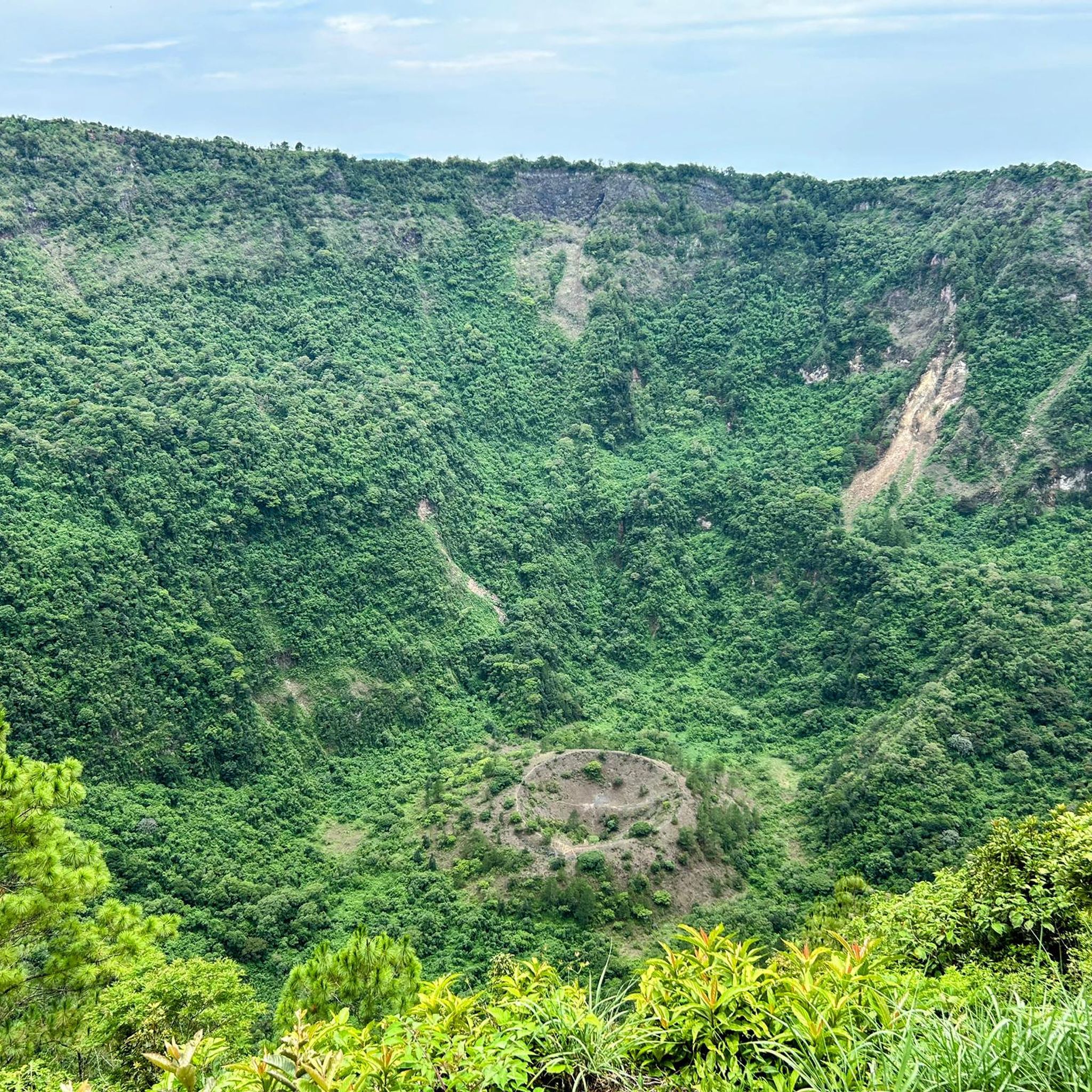
Jogging in Cráter El Boqueron Del Volcan De San Salvador offers routes through a unique volcanic landscape. The region is characterized by the large crater of the San Salvador Volcano, with its smaller cinder cone, El Boqueroncito, at its center. Trails traverse shaded cloud forests with tall pine trees and volcanic rock formations, providing a diverse environment for running. Situated at an elevation of about 1,800 meters (5,905 feet), the area maintains a cool temperate climate suitable for physical activity.
…Last updated: July 5, 2026
18
runners
15.8km
02:00
410m
410m
Hard run. Very good fitness required. Mostly accessible paths. Some sure footedness required.
28
runners
8.49km
00:53
90m
90m
Moderate run. Good fitness required. Mostly paved surfaces. Suitable for all skill levels.

Sign up for free
10
runners
16.6km
01:44
150m
150m
Hard run. Very good fitness required. Mostly paved surfaces. Suitable for all skill levels.
5.0
(1)
7
runners
24.1km
03:12
950m
950m
Hard run. Very good fitness required. Mostly paved surfaces. Suitable for all skill levels.
5.0
(1)
63
runners
5.45km
00:34
50m
50m
Moderate run. Good fitness required. Mostly paved surfaces. Suitable for all skill levels.
Get access to more routes and recommendations from other explorers.
Sign up for free
Already have an account?
Our route recommendations are based on thousands of hikes, rides, and runs completed by other people on komoot.
Start today with a free account
Your next adventure awaits.
Login or Signup
Popular around Cráter El Boqueron Del Volcan De San Salvador


Frequently Asked Questions
What kind of terrain can I expect on the running trails in Cráter El Boquerón?
The running trails in Cráter El Boquerón offer a diverse experience, transitioning from shaded cloud forests with tall pine trees to volcanic rock formations. While many paths are largely flat to moderate, some sections may involve uneven volcanic soil and occasional loose gravel, requiring appropriate footwear. The main draw is the colossal crater of the San Salvador Volcano, providing a unique and visually engaging backdrop for your run.
Are there any easy or beginner-friendly running routes in the area?
Yes, Cráter El Boquerón offers several routes suitable for beginners or those looking for an easier run. For example, the Running loop from Comunidad Santa Gertrudis is a moderate 2.8-mile (4.5 km) path with a consistent elevation gain of about 390 feet, making it a good option for a less strenuous outing.
What are the typical elevation gains on the jogging routes in Cráter El Boquerón?
The elevation gains vary significantly across the routes. While some moderate paths like the Running loop from Comunidad Santa Gertrudis have around 390 feet of elevation gain, more challenging routes such as the Bicentennial Park loop from Embassy of Germany can feature over 1,300 feet of ascent. The park's rim trail itself has about 800 feet of elevation gain and loss over its three-mile loop.
Can I bring my dog on the running trails in Cráter El Boquerón National Park?
The region is a protected area, and while specific dog policies for all trails can vary, it's generally advisable to check with park authorities regarding pet access within El Boquerón National Park. Some areas may have restrictions to protect local wildlife.
Are there any circular running routes available?
Yes, many of the routes in Cráter El Boquerón are designed as loops, offering a convenient circular experience. For instance, the Running loop from Embassy of the United States of America is a 5.3-mile (8.5 km) trail that provides a varied terrain loop, often completed in about an hour.
What is the best time of day or year to go running in Cráter El Boquerón?
The park, situated at about 1,800 meters (5,905 feet) elevation, boasts a refreshingly cool temperate climate year-round, making it comfortable for physical activity. It is generally advised to visit in the morning to enjoy clearer views, as afternoon fog can sometimes obscure the panoramic vistas.
What kind of views can I expect while running in this volcanic region?
Runners can enjoy breathtaking panoramic views of San Salvador city, Lake Ilopango, and the Chinchontepec volcano from various points along the trails. Several strategically located viewpoints, including a newer glass lookout, maximize these scenic vistas, providing a stunning backdrop to your run.
Are there places to eat or get refreshments near the running trails?
Yes, for those looking for a break or post-run refreshment, there are numerous restaurants and cafes along the road leading to El Boquerón National Park and within the visitor's area. Many of these establishments offer spectacular views and local cuisine.
How many running routes are available in Cráter El Boquerón Del Volcan De San Salvador?
There are over 25 running routes available in Cráter El Boquerón Del Volcan De San Salvador, catering to various difficulty levels from easy to difficult. This includes 4 easy routes, 17 moderate routes, and 8 difficult routes, ensuring options for every runner.
What do other runners enjoy most about the trails in Cráter El Boquerón?
The running routes in Cráter El Boquerón are highly rated by the komoot community, with an average score of 4.75 stars from over 10 reviews. Runners often praise the unique volcanic landscapes, the refreshing cool climate, and the stunning panoramic views of the city and surrounding natural features.
Is there public transport available to reach the running trails in Cráter El Boquerón?
While the region is accessible, specific public transport routes directly to the trailheads within El Boquerón National Park can be limited. It's recommended to research local bus services or consider ride-sharing options that can take you closer to the park entrance or main access points.
Are there any challenging running routes for experienced runners?
Absolutely. For experienced runners seeking a challenge, routes like the Mirador – Ecoparque El Espino loop from Santa Tecla offer significant distances and elevation gains. This particular route covers nearly 15 miles (24.2 km) and involves almost 3,100 feet of ascent, providing a demanding workout amidst the volcanic landscape.
Most popular routes in Cráter El Boqueron Del Volcan De San Salvador

Get inspired with the komoot mobile app


Explore more
Browse the best Running Trails & Routes in other regions.
