The best walks and hikes in Lane Cove National Park
4.5
(469)
8,950
hikers
12
hikes
Hiking in Lane Cove National Park offers diverse landscapes within metropolitan Sydney, encompassing 670 hectares along the riparian area of the Lane Cove River. The park features a blend of wet and dry sclerophyll forests, heathland, casuarina woodlands, and saltwater wetlands. Its terrain is often rugged, characterized by the slopes of the river valley covered in dense bush, with the Lane Cove River serving as a central feature. A weir divides the river into freshwater and tidal saltwater sections, adding to the varied environment.
Best hiking trails in Lane Cove National Park
- The most popular hiking route is Lane Cove River Weir – View of Lane Cove River loop from Macquarie Park, a 5.9 miles (9.6 km) moderate trail that takes 2 hours 33 minutes to complete, offering views of the Lane Cove River.
- Another top favourite among local hikers is Lane Cove River Weir – View of Lane Cove River loop from Chatswood West, a moderate 6.1 miles (9.8 km) path. This route provides extensive river views and traverses varied bushland ecosystems.
- Local hikers also love the View of Lane Cove River – Lane Cove National Park loop from Macquarie Park, a 4.6 miles (7.4 km) trail leading through the park's bushland and along the river, often completed in about 1 hour 57 minutes.
- Hiking in Lane Cove National Park is defined by its riparian areas, diverse sclerophyll forests, and the winding Lane Cove River. The network offers options for different ability levels, from easy strolls to more challenging routes.
- The routes in Lane Cove National Park are highly rated by the komoot community with an average score of 4.6 stars from over 280 reviews. More than 5,800 hikers have used komoot to explore Lane Cove National Park's varied terrain.
Last updated: October 18, 2026
4.6
(13)
181
hikers
10.4km
02:44
80m
80m
Moderate hike. Good fitness required. Easily-accessible paths. Suitable for all skill levels.
4.5
(15)
178
hikers
9.95km
02:37
90m
90m
Moderate hike. Good fitness required. Easily-accessible paths. Suitable for all skill levels.

24
hikers
5.35km
01:28
80m
80m
Easy hike. Great for any fitness level. Easily-accessible paths. Suitable for all skill levels.
4.0
(2)
16
hikers
11.8km
03:12
170m
170m
Moderate hike. Good fitness required. Easily-accessible paths. Suitable for all skill levels.
5.0
(1)
13
hikers
5.69km
01:35
100m
100m
Easy hike. Great for any fitness level. Easily-accessible paths. Suitable for all skill levels.
Get access to more routes and recommendations from other explorers.
Already have an account?
Our route recommendations are based on thousands of hikes, rides, and runs completed by other people on komoot.
Start today with a free account
Your next adventure awaits.


Tips from the Community

A short side track off the Step Track brings you out to this rocky lookout above the Lane Cove valley. The view is more about layers of bushland than a big open panorama, with eucalypts filling the slopes below and the valley dropping away through the trees. It’s only a quick detour from the main track, so it’s well worth following the Scenic Views sign when you reach the junction.
0
0

Terrys Creek Walking Track follows its namesake creek through a peaceful corridor of remnant bushland between Epping and Eastwood, part of Lane Cove National Park. The path winds past a small waterfall, ducks beneath the M2 motorway, and continues on to Browns Waterhole, with a mix of natural bush trail, metal walkways, and wooden steps along the way. The terrain can be uneven with roots and rocks in places, and the track can turn boggy or even flood after heavy rain, so it's best to tackle it in dry weather.
0
0
The Riverside Walking Track follows the edge of the Lane Cove River through shaded bushland, mangroves, and quiet picnic areas in the heart of the national park. The track mixes sealed paths, boardwalks, dirt sections, and short stair climbs, with regular river views and several spots to stop beside the water along the way. It’s one of the park’s most accessible walks, linking the weir, riverside cafés, picnic grounds, and bushier sections further upstream.
0
0
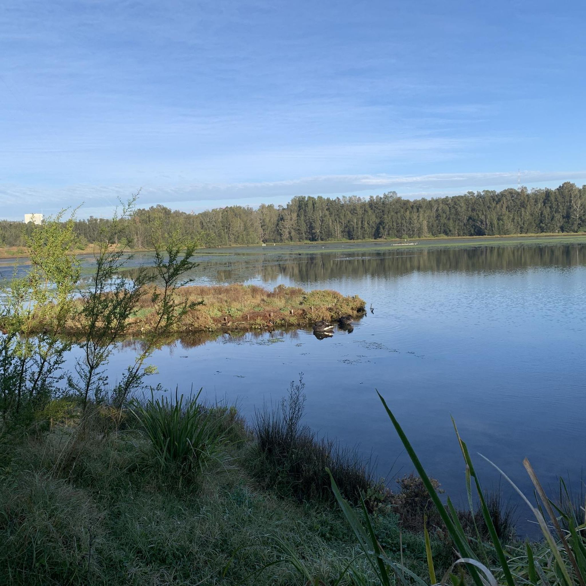
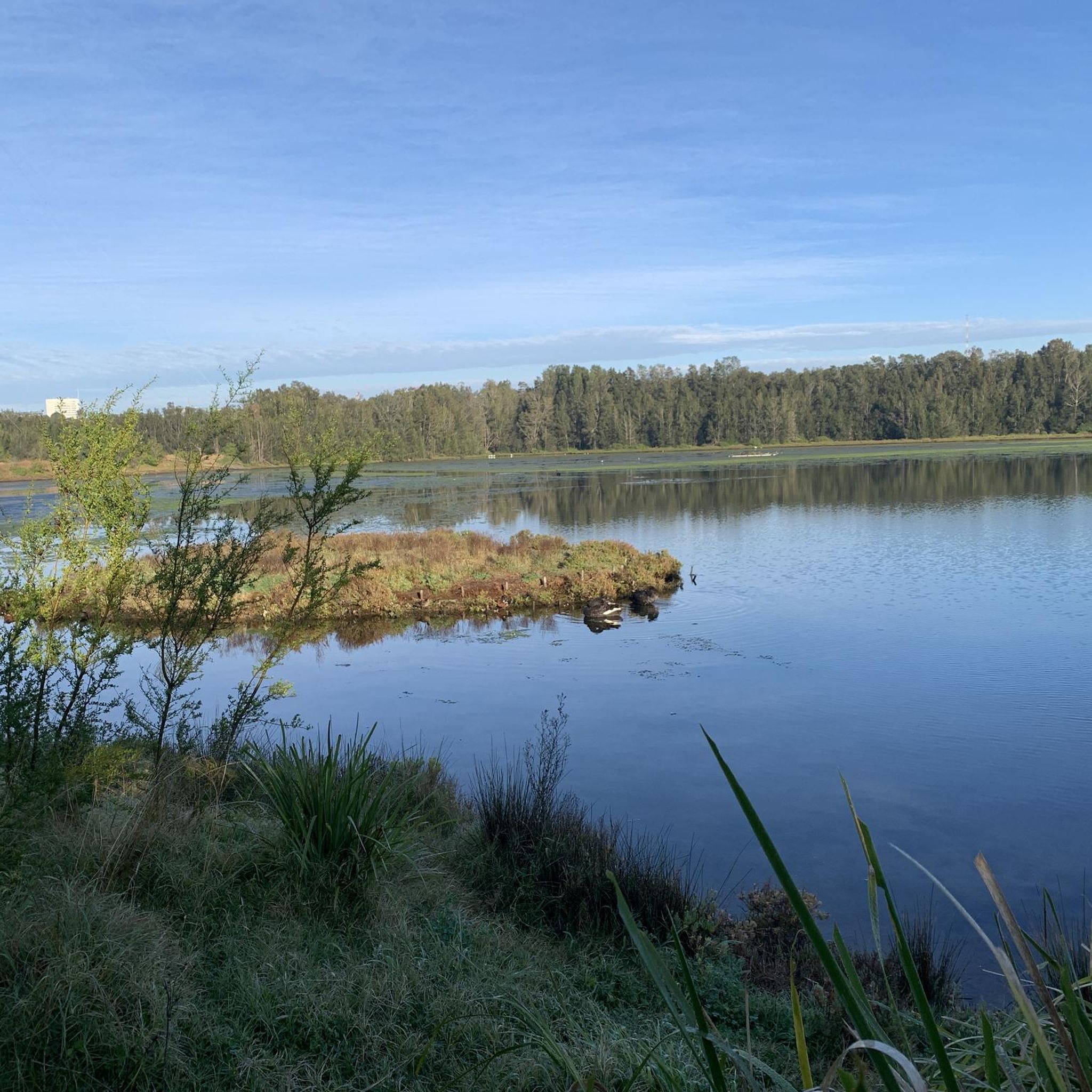
The Lane Cove River winds through the centre of the national park, surrounded by sandstone bushland, mangroves, and tall eucalypts that make this stretch feel far removed from suburban Sydney. Along the Riverside Walking Track, the river alternates between still sections near the weir and narrower bush-lined bends further upstream, with regular sightings of water dragons, ducks, herons, and cockatoos along the banks. The calm water also makes this one of the park’s most popular areas for kayaking and canoeing.
0
0
This riverside lookout sits beside the Lane Cove Weir, with clear views across the calm water and surrounding bushland from the edge of the track. It’s an easy place to pause along the Riverside Walk, especially early in the morning when the river is still and reflections sit across the water beneath the gums.
0
0
Devlins Creek Trail follows the creek corridor through shaded bushland, linking narrower single-track sections with rocky creek crossings and sandstone terrain. Compared to the wider fire trails higher in the park, this route feels more enclosed, with dense vegetation and a rougher surface underfoot. Tree roots, rocks, and smaller creek crossings slow the pace in sections, especially after rain when parts of the track can become muddy or slippery. The trail also forms part of the wider Great North Walk network through Lane Cove National Park.
0
0
Devlins Creek is a sandstone creek system flowing through the upper sections of Lane Cove National Park before joining Terrys Creek to form the Lane Cove River. Along the trail, the creek passes through shaded bushland with rocky banks, shallow crossings, and small waterholes tucked beneath the forest canopy. Water flow varies depending on rainfall, with calmer pools in drier periods and stronger movement after rain. The creek is named after James Devlin, a nineteenth century landowner connected to the area.
0
0
Pennant Hills Trail follows a management-style bush track through eucalypt forest on the upper edges of Lane Cove National Park. The trail is wider and more open than the narrower river tracks below, with long stretches of dirt and gravel surface underfoot. Sections connect into older fire trails and parts of the wider Great North Walk network, with steady climbs and descents through the bushland. Wildlife such as wallabies, water dragons, and birdlife are commonly seen along quieter sections of the trail.
0
0
Frequently Asked Questions
How many hiking trails are available in Lane Cove National Park?
Lane Cove National Park offers a variety of hiking experiences, with over 10 distinct routes available on komoot. These range from easy strolls to more moderate challenges, ensuring options for different fitness levels.
Are there easy hiking trails suitable for beginners or families in Lane Cove National Park?
Yes, Lane Cove National Park has several easy trails perfect for beginners or families. For example, the View of Lane Cove River – Lane Cove National Park loop from Macquarie Park is an easy 7.4 km path, often completed in under two hours. Another gentle option is the Lane Cove River Weir – Maffrey Park Picnic Area loop from Chatswood West, which is just over 4.5 km.
What kind of landscapes can I expect to see while hiking in Lane Cove National Park?
Hikers in Lane Cove National Park will experience a diverse range of ecosystems, including wet and dry sclerophyll forests, heathland, casuarina woodlands, and saltwater wetlands. The terrain is often rugged, characterized by dense bush on the slopes of the Lane Cove River valley, which itself is a central and scenic feature.
Are dogs allowed on the hiking trails in Lane Cove National Park?
Lane Cove National Park has specific rules regarding dogs. Generally, dogs are not permitted on walking tracks or in national park bushland areas to protect native wildlife. However, they are allowed in some picnic areas and on sealed roads within the park, provided they are on a leash. It's always best to check the official NSW National Parks website for the most current regulations: nationalparks.nsw.gov.au.
What are some notable attractions or points of interest along the trails?
Many trails follow the scenic Lane Cove River, offering picturesque views. You can visit the historic site of Fairylands Pleasure Grounds, explore the Lane Cove River Weir with its fish ladder, or discover historical sites like Schwartz Homestead along the Fiddens Wharf Walking Track. The park also features numerous picnic areas with tables and barbecues, ideal for a break.
Are there any circular hiking routes in Lane Cove National Park?
Yes, many of the trails in Lane Cove National Park are circular, allowing you to start and end at the same point. Examples include the Lane Cove River Weir – View of Lane Cove River loop from Macquarie Park, a moderate 9.6 km route, and the Golf Course loop from Chatswood West, an easy 5.58 km option.
What kind of wildlife can I spot while hiking in the park?
Lane Cove National Park is home to diverse wildlife. Hikers often have the chance to spot echidnas, swamp wallabies, eastern water dragons, and a variety of bird species, including kookaburras. The river itself is a habitat for ducks and fish.
Is there parking available for hikers in Lane Cove National Park?
Yes, there are various parking areas located throughout Lane Cove National Park, especially near popular trailheads and picnic spots. Vehicle entry to the park typically incurs a fee, so it's advisable to check the NSW National Parks website for current information on fees and parking locations before your visit.
Can I reach Lane Cove National Park trails using public transport?
Lane Cove National Park is conveniently located just 10 kilometers from the Sydney CBD, making it accessible by public transport. Various bus routes service areas around the park, and some trailheads may be within walking distance of bus stops. Planning your route with a public transport app is recommended to find the best connection to your desired starting point.
What do other hikers enjoy most about Lane Cove National Park?
The komoot community highly rates hiking in Lane Cove National Park, with an average score of 4.6 stars from over 280 reviews. Hikers frequently praise the park's diverse landscapes, the scenic river views, and the convenience of having such a rich natural environment so close to metropolitan Sydney. The variety of trails, from easy to moderate, is also a popular aspect.
Are there any longer, more challenging hikes in Lane Cove National Park?
While Lane Cove National Park primarily features easy to moderate trails, some routes offer a longer experience. For instance, the Lane Cove River Weir – View of Lane Cove River loop from Chatswood West is a moderate 9.8 km path that provides extensive river views and traverses varied bushland ecosystems, offering a good workout.
What are the best times of year to go hiking in Lane Cove National Park?
Lane Cove National Park can be enjoyed year-round, but the cooler months of autumn (March to May) and spring (September to November) are often considered ideal for hiking. During these seasons, the weather is milder, making for more comfortable conditions to explore the park's diverse flora and fauna without the intense heat of summer.
Most popular routes in Lane Cove National Park
Most popular attractions in Lane Cove National Park

Get inspired with the komoot mobile app


Explore more
Browse the best Hikes in other regions.
