The best cycling routes around Macieira De Alcoba
3.0
(1)
10
riders
4
rides
Touring cycling routes around Macieira De Alcoba traverse a landscape characterized by dramatic granite formations and varied topography, with altitudes ranging from approximately 180 meters near the Águeda River to 762 meters in the Urgueira hills. The region is shaped by the river valleys of Águeda and Alfusqueiro, creating humid valleys sheltered by rounded granite and schist hills. Natural vegetation includes ancient oaks, cork oaks, sweet chestnut trees, and various shrubs, remnants of the primitive forests of the Serra do…
Last updated: July 11, 2026
58.8km
04:17
1,300m
1,300m
Hard bike ride. Very good fitness required. Mostly paved surfaces. Suitable for all skill levels.
3
riders
Hard bike ride. Very good fitness required. Mostly paved surfaces. Suitable for all skill levels.

Sign up for free
4
riders
77.5km
06:51
1,770m
1,770m
Hard bike ride. Very good fitness required. Mostly paved surfaces. Suitable for all skill levels.
3.0
(1)
3
riders
59.7km
04:10
1,120m
1,120m
Hard bike ride. Very good fitness required. Mostly paved surfaces. Suitable for all skill levels.
Our route recommendations are based on thousands of hikes, rides, and runs completed by other people on komoot.
Start today with a free account
Your next adventure awaits.
Login or Signup
Popular around Macieira De Alcoba
Tips from the Community

In front of the tourist information there is a small work of art, a red umbrella.
6
1

A spectacular windy descent passing through the middle of the Alfusqueiro river!!
1
0

It all started in 2012, with a simple idea that became an international success. The idea came about as part of a renowned local festival supported by the local authority, AgitÁgueda. Between music, performances and art, an unparalleled installation was created: “the project is called Umbrella Sky and is located mainly on Rua Luís de Camões in Águeda, its main street.
0
0

Tourist Office opening hours Tuesday to Saturday: from 10:00 to 13:00 and from 14:00 to 18:00
0
0

The tourist information office begins at the southern entrance to Agueda, just to the left behind the bridge. You can ask for the key to the toilet there. It is a good place to go, especially for women after the long Caminho through the industrial area. You can also get a stamp for your pilgrim's passport. The staff don't necessarily speak much English, but you can communicate.
2
0

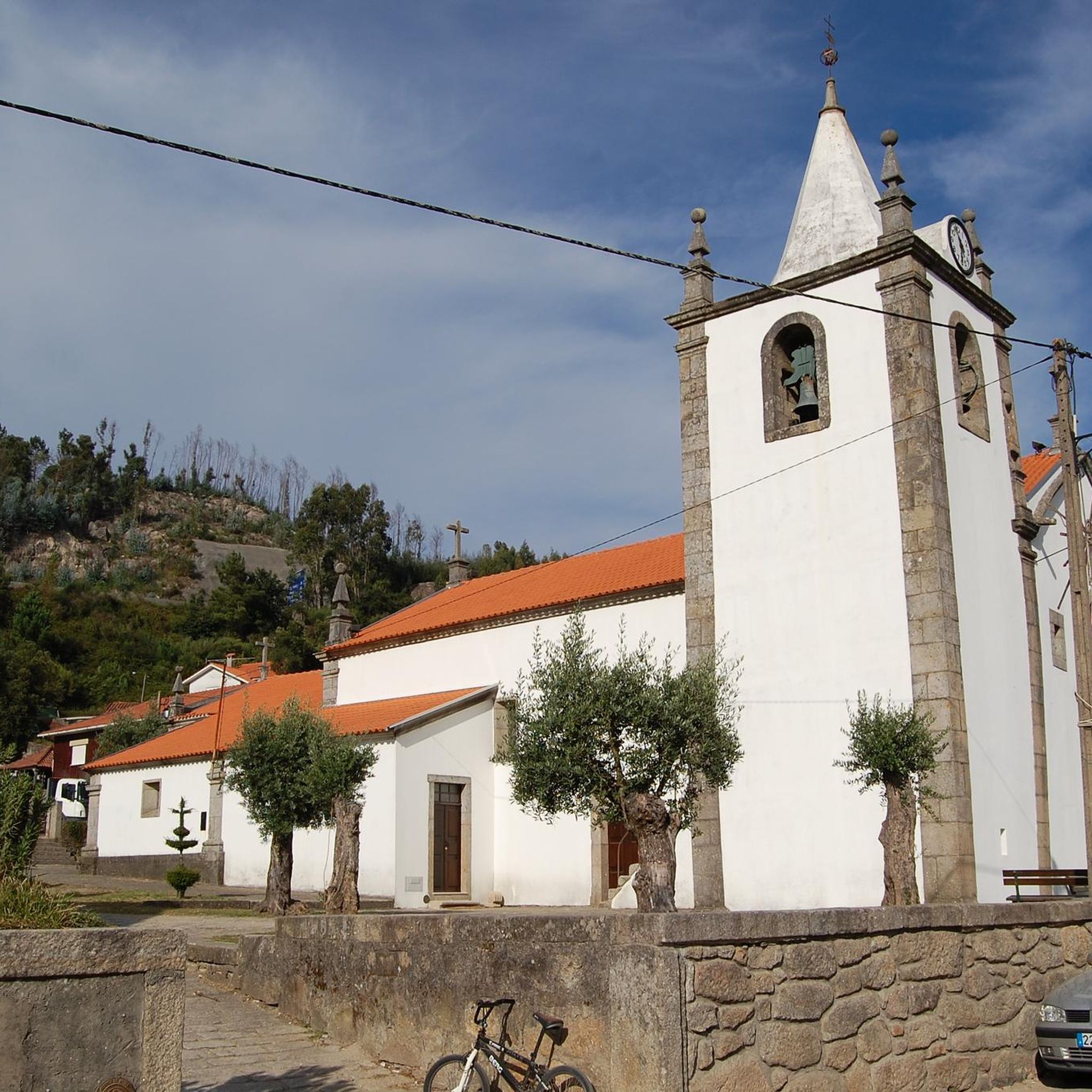
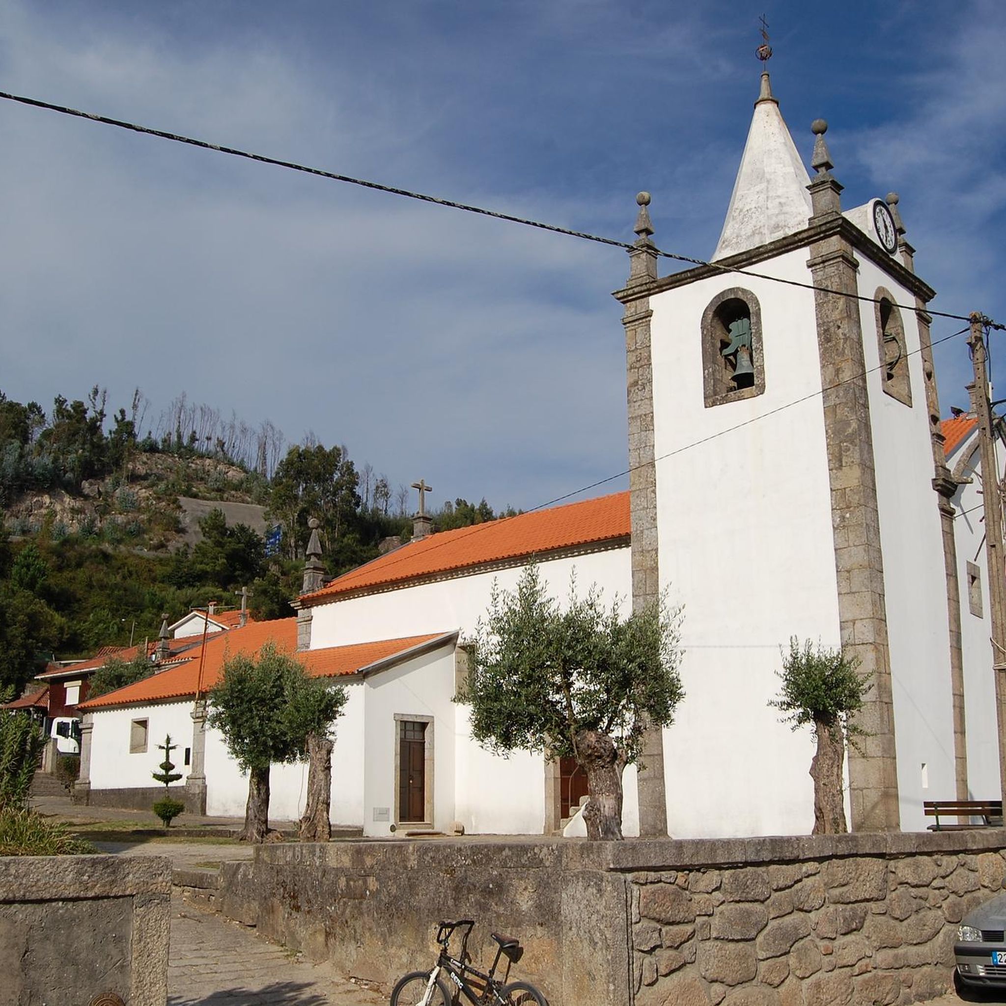
The main church, originally in Doninhas, moved to its current location between 1686 and 1707. It has baroque gilded altars and a ceiling decorated with paintings of the Passion of Christ and saints. In the churchyard, ancient olive trees and the rectory stand out. Every year, the Parade of the Three Kings takes place, a tradition that has been going on for over 50 years.
0
0
The Cercosa Dam, on the Alfusqueiro river in Vouzela, district of Viseu, began operations in 1994. It is a gravity dam with a hydroelectric plant, capable of producing 9.65 Mio. kWh annually.
0
0
São João do Monte River Beach, also known as Paraíso River Beach, is a calm and great place to spend the day by the river. It offers infrastructure such as a bar, snacks and bathrooms, as well as a historic Romanesque bridge.
0
0
Frequently Asked Questions
What is the general difficulty level of touring cycling routes around Macieira de Alcôba?
The touring cycling routes in Macieira de Alcôba are generally considered challenging. All five routes listed in this guide are rated as difficult, featuring significant elevation changes due to the region's dramatic granite formations and varied topography, with altitudes ranging from 180 meters near the Águeda River to 762 meters in the Urgueira hills.
Are there any family-friendly touring cycling routes in Macieira de Alcôba?
Given the challenging terrain and significant elevation gains, the touring cycling routes around Macieira de Alcôba are generally not recommended for families with young children or those seeking easy, flat rides. All routes in this guide are rated as difficult. However, the region does offer marked trails like the PR3 - Trilho da Aldeia (Village Trail) which might be suitable for walking or shorter, less strenuous cycling excursions on appropriate bikes.
Can I bring my dog on the touring cycling trails in Macieira de Alcôba?
While specific regulations for dogs on cycling trails are not detailed, the natural environment of Macieira de Alcôba, with its diverse vegetation and rural paths, is generally welcoming to dogs. It's always advisable to keep your dog on a leash, especially near villages or livestock, and to ensure they are fit enough for the challenging terrain. Remember to carry water for both yourself and your pet.
What kind of natural features and landmarks can I expect to see along the touring cycling routes?
The routes traverse a landscape rich in natural beauty and historical elements. You'll encounter dramatic granite formations, river valleys carved by the Águeda and Alfusqueiro rivers, and remnants of ancient forests with oaks, cork oaks, and chestnut trees. Notable landmarks include the historic Alfusqueiro Bridge, which may have Roman origins, and the scenic São João do Monte River Beach. The Caramulinho Summit offers panoramic views, and you might discover a Chapel of the Infant Jesus (Viewpoint).
Are there any circular touring cycling routes available?
Yes, several touring cycling routes in Macieira de Alcôba are designed as loops. For example, the route From Talhadas to São João do Monte — circular route is a 36.5-mile (58.8 km) loop. Another option is the Parque Fluvial do Alfusqueiro – Alfusqueiro Bridge loop from Aguieira, which is a longer 48.2-mile (77.5 km) path exploring the Alfusqueiro river valley. There's also the Alfusqueiro Bridge – Parque Fluvial do Alfusqueiro loop from Castanheira do Vouga, a 15.5-mile (25.0 km) trail.
What is the best time of year to go touring cycling in Macieira de Alcôba?
The region's climate, typical of central Portugal, suggests spring (April-May) and autumn (September-October) are ideal for touring cycling. During these seasons, temperatures are generally milder, and the natural vegetation is vibrant. Summer months can be quite hot, especially in the river valleys, making early morning or late afternoon rides preferable. Winters are cooler and can bring rain, but cycling is still possible on drier days.
Where can I find parking for touring cycling routes in Macieira de Alcôba?
While specific designated parking areas for each route are not detailed, Macieira de Alcôba and its surrounding villages like Urgueira, Carvalho, and Carvalhal offer various points where you can typically find parking. Look for public parking in village centers or near known attractions like the Piscina Fluvial or the São João do Monte River Beach. Always ensure you park responsibly and do not obstruct local access.
Are there any cafes or places to stop for refreshments along the cycling routes?
Macieira de Alcôba and the traditional villages you'll pass through, such as Urgueira, are home to local establishments where you can find refreshments. These often include small cafes or tascas offering traditional Portuguese snacks and drinks. The São João do Monte River Beach also provides amenities, and the Piscina Fluvial de Macieira de Alcôba offers a refreshing stop during warmer months.
What cultural attractions can I explore while touring cycling in the area?
Macieira de Alcôba is known as the 'Aldeia Pedagógica do Milho Antigo' (Pedagogical Village of Ancient Corn), featuring an Interpretive Center dedicated to traditional agricultural practices. You can also explore the charming traditional stone houses and picturesque streets of Macieira de Alcôba and neighboring villages. The Alfusqueiro Bridge, with its historical significance, and restored Moinhos de rodízio (watermills) like Moinho de Novo and Moinho Pequeno, offer glimpses into the region's rich rural heritage.
What makes the touring cycling experience in Macieira de Alcôba unique?
The unique blend of dramatic granite landscapes, varied topography, and rich cultural heritage sets Macieira de Alcôba apart. Cyclists can explore ancient oak and chestnut forests, traverse river valleys, and discover traditional villages with stone architecture. The presence of historical structures like watermills and granaries, alongside initiatives like the 'Aldeia Pedagógica do Milho Antigo', offers a deep immersion into the authentic rural heart of Portugal, providing a dynamic and culturally enriching cycling experience.
How long do the touring cycling routes typically take to complete?
The duration varies significantly depending on the route's length and your pace, but generally, these are not short rides. For instance, the From Talhadas to São João do Monte — circular route, at 36.5 miles (58.8 km), typically takes around 4 hours and 17 minutes. A longer route like Parque Fluvial do Alfusqueiro – Alfusqueiro Bridge loop from Aguieira, spanning 48.2 miles (77.5 km), can take over 6 hours. Even shorter routes, such as the Bike loop from Castanheira do Vouga (19.6 miles / 31.6 km), are rated difficult and can take over 2 hours and 30 minutes.
What should I bring for a touring cycling trip in Macieira de Alcôba?
Given the challenging nature of the routes and the varied terrain, it's essential to be well-prepared. We recommend bringing plenty of water, especially during warmer months, as well as snacks for energy. A repair kit, spare inner tubes, and a pump are crucial. Appropriate cycling attire, including a helmet, gloves, and sunglasses, is advised. A fully charged phone with GPS capabilities (like the komoot app) is also highly recommended for navigation, as some areas can be remote.
Most popular routes around Macieira De Alcoba
Most popular attractions around Macieira De Alcoba

Get inspired with the komoot mobile app


Explore more
Browse the best Cycling routes in other regions.
