The best running trails around Meyers
4.2
(7)
141
runners
35
runs
Jogging routes around Meyers are set within the Sierra Nevada mountains, offering diverse terrain for runners. The region features high-elevation trails, pristine alpine lakes like Echo Lake and Fallen Leaf Lake, and the scenic Upper Truckee River. Surrounded by the Desolation Wilderness, Meyers provides a mix of paved paths and challenging wilderness trails, catering to various fitness levels.
Best jogging routes around Meyers
- The most popular jogging route is Echo Lake via Tahoe Rim Trail — Lake Tahoe Basin Management…
Last updated: June 24, 2026
11
runners
9.60km
01:12
130m
130m
Embark on a moderate jogging route along the Echo Lake via Tahoe Rim Trail, covering 6.0 miles (9.6 km) with an elevation gain of 424 feet (129 metres). This journey,…
2
runners
5.75km
00:38
60m
60m
Jog the Lake Tahoe Boulevard Bike Path, a 3.6-mile paved route with moderate difficulty, offering diverse scenery and lake views.

Sign up for free
2
runners
8.57km
01:07
210m
210m
Jog the moderate 5.3-mile Grass Lake Trail in Desolation Wilderness, gaining 703 feet in elevation through forests to Grass Lake.
20.0km
02:53
720m
720m
Jogging the Lake Aloha via Pacific Crest Trail in Desolation Wilderness is a difficult 12.4-mile route with 2365 feet of elevation gain.
8.29km
01:26
570m
570m
Jog the difficult 5.2-mile Gilmore Lake via Mount Tallac Trail in Desolation Wilderness, gaining 1858 feet for stunning alpine views.
Get access to more routes and recommendations from other explorers.
Sign up for free
Already have an account?
Our route recommendations are based on thousands of hikes, rides, and runs completed by other people on komoot.
Start today with a free account
Your next adventure awaits.
Login or Signup
Tips from the Community

Lake Tahoe Boulevard Bike Path is a wonderful multiuse trail that winds through a beautiful forest. The path is used by cyclists, walkers and runners, so make sure you are aware of other users while out on the trail.
0
0

Hop on or off the PCT to view several alpine lakes. Along the route you will find Lake Aloha, Lake of The Woods, and American Lake among many others. If you're heading back to Fallen Leaf, take a right at this point.
0
0

Lake Aloha or Aloha Lake is just around the corner of South Lake Tahoe. Nestled in the already beautiful Desolation Wilderness, this lake is a true gem and you just have to take a break at the shore. After all, it is a picture postcard view.
0
0
Grass Lake is a picturesque alpine lake surrounded by granite slopes. It's the perfect resting spot.
0
0

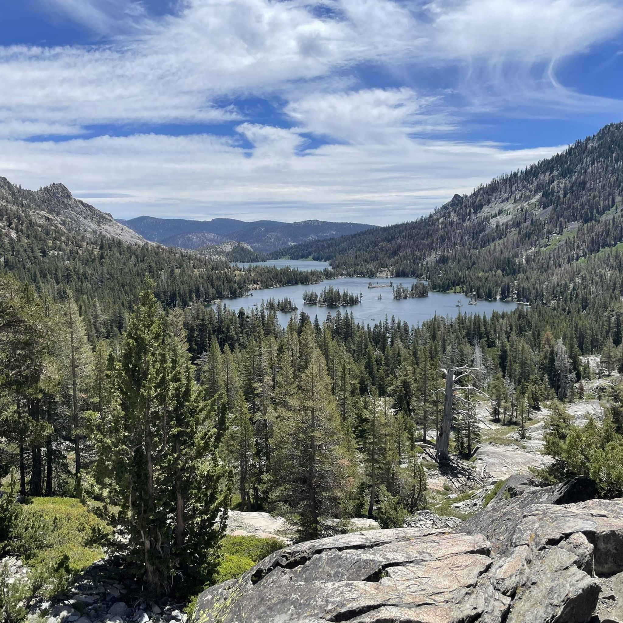
The entire hike along the north shore of Lower Echo Lake offers great views, but they're particularly nice from here.
1
0
A well-preserved landmark and historic spring that was used over 150 years ago at the 19th-century Glen Alpine Resort. It is one of several points of interest on the trail.
1
0
Grass Lake is a picturesque alpine lake surrounded by granite slopes. It's the perfect resting spot.
0
0
Hop on or off the PCT to view several alpine lakes. Along the route, you will find Lake Aloha, Lake of the Woods, and American Lake, among many others. If you're heading back to Fallen Leaf, take a right at this point.
0
0
Frequently Asked Questions
How many running routes are available in Meyers?
Meyers offers a wide variety of running routes, with over 35 different trails to explore. These range from easy, paved paths to challenging, high-elevation mountain runs, catering to all fitness levels.
Are there dog-friendly running trails in Meyers?
Yes, many trails in Meyers are dog-friendly, though leash laws and specific regulations may apply, especially within the Desolation Wilderness. The Lake Tahoe Boulevard Bike Path run is a popular option for runners with dogs, offering a mostly paved surface. Always ensure your dog is well-behaved and pick up after them.
Are there running paths suitable for families or strollers in Meyers?
For families and those with strollers, the paved sections of the Upper Truckee River Bike Path and the Lake Tahoe Boulevard Bike Path run are excellent choices. These routes offer accessible, scenic experiences without significant elevation changes, making them ideal for a leisurely family run.
Where can I find parking for running trails in Meyers?
Parking is generally available at trailheads and designated access points throughout Meyers. For trails like the Echo Lake via Tahoe Rim Trail, parking can be found near Echo Lake. For routes along bike paths, look for parking areas adjacent to the paths or in nearby public lots. It's always advisable to check specific trailhead information for parking availability and any potential fees or permit requirements.
What are some easy or beginner-friendly running routes in Meyers?
Beginner runners will enjoy the more accessible options like the Upper Truckee River Bike Path, which is paved and relatively flat. The Lake Tahoe Boulevard Bike Path run is another moderate, mostly paved route suitable for all skill levels, offering scenic views without significant challenge.
Which running routes offer the best scenic views in Meyers?
Meyers is renowned for its stunning scenery. Routes like the Echo Lake via Tahoe Rim Trail provide breathtaking views of Echo Lake and the surrounding Sierra Nevada mountains. For panoramic vistas of the Tahoe Basin and Emerald Bay, trails leading towards Mount Tallac, such as the Mount Tallac via Floating Island Trail, are highly recommended.
Where can I find more challenging running trails around Meyers?
For experienced trail runners seeking a challenge, the Desolation Wilderness offers rugged terrain and significant elevation gains. Trails like Gilmore Lake via Mount Tallac Trail and Mount Tallac via Floating Island Trail provide demanding climbs and technical sections with rewarding views. The Pacific Crest Trail, accessible near Echo Summit, also offers challenging high-elevation running experiences.
When is the best time of year to go running in Meyers?
The best time for running in Meyers is typically from late spring through early fall (May to October) when the weather is mild, and trails are clear of snow. During these months, you can enjoy the crisp mountain air and vibrant natural scenery. Winter running is possible on lower-elevation paved paths, but higher mountain trails will be snow-covered and require appropriate gear like snowshoes or cross-country skis.
What do other runners enjoy the most about jogging in Meyers?
The running routes in Meyers are highly rated by the komoot community, with an average score of 4.0 stars. Reviewers often praise the stunning natural surroundings, including the Sierra Nevada mountains and pristine lakes, as well as the diverse terrain that caters to various fitness levels. The inspiring backdrop of Lake Tahoe and the Desolation Wilderness makes for a memorable running experience.
Are there any loop running trails in Meyers?
Yes, Meyers offers several loop running options. While specific named loop trails vary, many routes can be combined or are inherently circular, especially within the extensive network of trails in the Desolation Wilderness. For example, the Echo Lake via Tahoe Rim Trail offers a moderate loop experience around the lake area.
What natural attractions can I see along the running routes in Meyers?
Running in Meyers provides access to incredible natural attractions. You can encounter pristine alpine lakes like Lower Echo Lake, Fallen Leaf Lake, and Floating Island Lake. Many trails offer views of the majestic Sierra Nevada mountains, including prominent peaks like Mount Tallac Summit, and the expansive Desolation Wilderness.
Is public transport available to access running trails in Meyers?
Public transport options in Meyers are limited, and most trailheads are best accessed by car. However, some local bus services might connect to main areas or specific points near popular paths. For direct access to many of the more remote or wilderness trails, personal vehicle transport is generally recommended.
Most popular routes around Meyers
Most popular attractions around Meyers

Get inspired with the komoot mobile app


Explore more
Browse the best Running Trails & Routes in other regions.
