The best walks and hikes in Floyd County
4.7
(6)
153
hikers
12
hikes
Hikes in Floyd County explore the landscape of the Blue Ridge Mountains in Southwest Virginia. The region is characterized by its section of the Blue Ridge Parkway, which provides access to forested trails, deep gorges, and unique natural preserves. The routes feature a mix of terrain, from riverside paths to the wind-exposed summit of Buffalo Mountain.
Best hiking trails in Floyd County
- The most popular hiking route is Rock Castle Gorge Loop Trail — Rocky Knob Recreation Area, a 10.7 mile (17.3 km) trail that takes about 5 hours 26 minutes to complete. This difficult hike descends into a gorge with significant elevation change.
- Another top favourite among local hiking enthusiasts is Buffalo Mountain loop from Buffalo Mountain Natural Area Preserve, a moderate 1.7 mile (2.8 km) path. This route leads to a treeless summit with panoramic views of the surrounding area.
- Local hiking enthusiasts also love the Stiles Falls — Shawsville, Virginia, a 3.1 mile (5.0 km) trail leading through woodland to a waterfall, often completed in about 1 hour 26 minutes.
- Hiking in Floyd County is defined by forested paths along the Blue Ridge Parkway, ascents to mountain summits, and trails through stream-filled gorges. The trail network offers options for different ability levels, from easy family-friendly hikes to more challenging routes.
- The routes in Floyd County are highly rated by the komoot community with an average score of 4.7 stars from a number of reviews. More than 100 hikers have used komoot to explore Floyd County's varied terrain.
Last updated: June 23, 2026
5.0
(1)
34
hikers
5.09km
01:29
140m
140m
The Black Ridge Trail is a delightful easy loop hike that packs a surprising amount of scenic variety into its 3.2 miles (5.1 km). You'll wander through dense rhododendron thickets, cross grassy knolls, and pass by the remnants of an old stone chimney, all while enjoying mountain vistas through the trees and open views of the Rock Castle Gorge. The path itself is a mix of smooth dirt, rocky sections, and wide grassy tracks, making for an engaging experience without being overly strenuous.
Planning your visit to this popular Blue Ridge Parkway trail is straightforward. Parking is available, though it's wise to arrive early during peak times. The trail is dog-friendly and considered one of the best family friendly hikes in the area, making it ideal for a leisurely outing. With an estimated duration of 1 hour and 29 minutes and only 465 feet (142 metres) of elevation gain, it's a perfect choice for a quick, rewarding escape.
What makes the Black Ridge Trail stand out is its blend of natural beauty and historical intrigue. A portion of the route overlaps with the Rock Castle Gorge Trail, adding to its regional significance. Keep an eye out for local birdlife, like hooded warblers during nesting season, as you traverse the changing landscapes from forested areas to open pastures. It's a fantastic way to experience the charm of Floyd County, Virginia.
2
hikers
617m
00:09
0m
0m
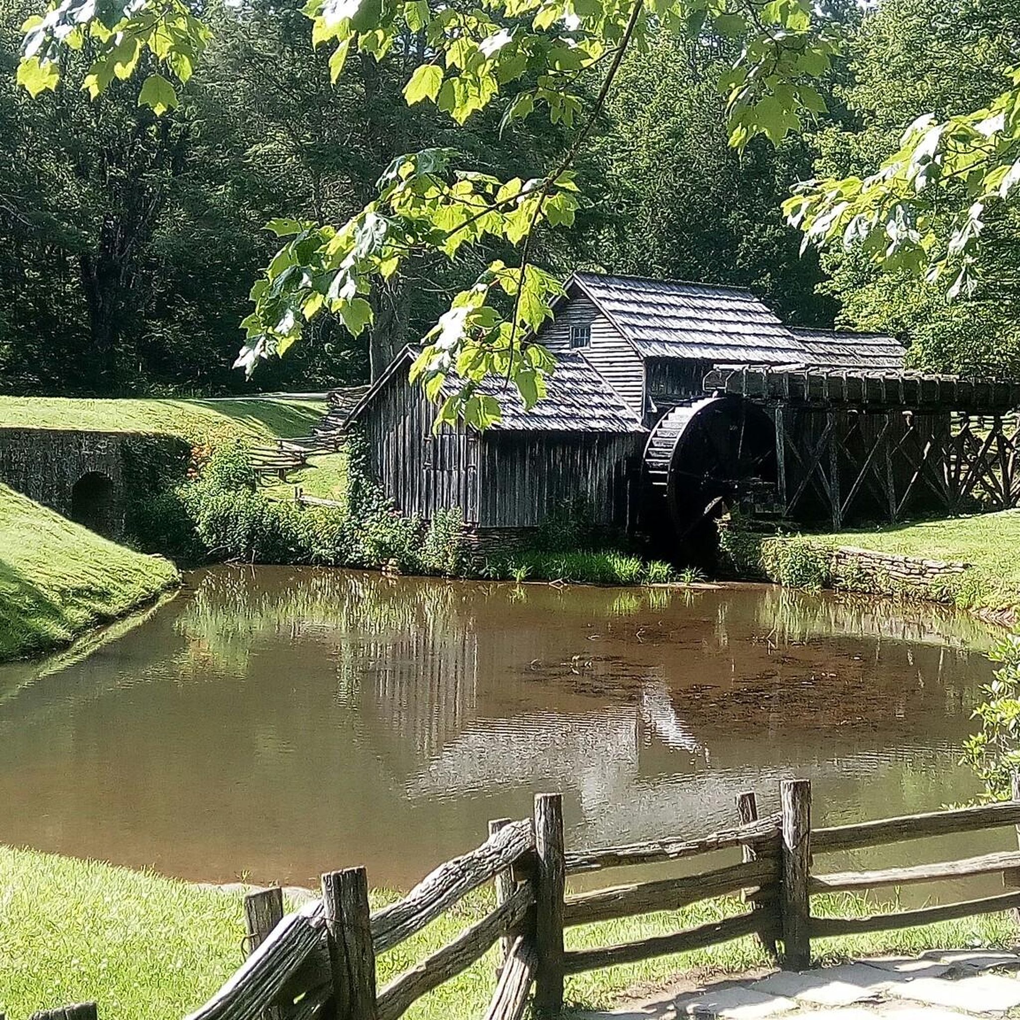
The Mabry Mill Trail offers a delightful, easy loop through a vibrant deciduous forest, making it a perfect quick escape. The iconic Mabry Mill, reflected in its pond, is the centerpiece of this picturesque scenery, surrounded by towering sycamore and yellow poplar trees. This 0.4-mile (0.6 km) route is mostly paved, making it a gentle 9-minute stroll with only 10 feet (3 metres) of elevation gain, ideal for a relaxing walk.
This easy hiking trail is a popular stop along the Blue Ridge Parkway, with parking readily available at the Mabry Mill site. During peak seasons, you might catch National Park Service volunteers demonstrating traditional crafts like gristmilling or blacksmithing, adding a unique cultural element to your visit. Spring blooms and vibrant fall foliage offer particularly beautiful times to experience the trail.
What makes this trail truly notable is its combination of natural beauty and historical significance. Along the route, you'll find well-preserved historical exhibits, including a functioning gristmill, sawmill, and blacksmith shop, along with the Matthews Cabin. Interpretive signage provides insights into early 20th-century rural Appalachian life, offering a peaceful journey into the region's heritage.

Sign up for free
2.48km
00:44
120m
0m
The Stiles Falls Trail offers a delightful escape into nature, leading you through varied terrain to a picturesque 40- to 50-foot waterfall. Starting on a gravel path, the route soon transitions to dirt and rock, closely following Purgatory Creek where you'll encounter lush greenery and wildflowers. This easy hiking route covers 1.5 miles (2.5 km) with 388 feet (118 metres) of elevation gain, typically completed in about 44 minutes, making it a perfect short adventure.
To plan your visit, know that the trail is on the private land of Camp Alta Mons but is open to the public from dawn to dusk; remember to sign in at the trailhead. Sturdy hiking boots are highly recommended for the three creek crossings and the final rocky scramble to the falls. Spring and fall offer the most comfortable temperatures and beautiful scenery for your hike.
This trail is notable not just for its natural beauty but also for its unique history, said to be named after Randolph Stiles, a Confederate sailor who met an unfortunate end here. It's a popular spot for families and beginners, providing a rewarding destination that feels much further from civilization than its short distance suggests.
5.0
(1)
27
hikers
4.97km
01:27
130m
130m
The Stiles Falls Trail offers a rewarding journey through diverse terrain, culminating in the majestic 40-50 foot Stiles Falls. As you hike, you'll follow Purgatory Creek, enjoying continuous views of cascading water and large boulders, surrounded by lush forests and wildflowers. The path transitions from a gravel road to grass, dirt, and rocks, providing a varied and engaging experience for hikers of all levels.
Planning your visit requires a quick check of the Alta Mons website, as the trail is on private property and may close during camps or inclement weather. You'll need to sign in upon arrival, and while the trail is generally open from dawn to dusk, verifying its status is key. Be prepared for three stream crossings over Purgatory Creek, which often involve rock-hopping and could lead to wet feet.
This easy 3.1-mile (5.0 km) hike, with 421 feet (128 metres) of elevation gain and an estimated duration of 1 hour and 26 minutes, is a fantastic option for families. Beyond the waterfall, you'll find information plaques detailing the history of the Crockett family, who once bottled water from the area, adding a touch of local lore to your adventure.
5.0
(1)
24
hikers
17.3km
05:27
690m
690m
Hike the difficult 10.7-mile Rock Castle Gorge Loop Trail, gaining 2255 feet through diverse terrain and stunning overlooks.
4.7
(3)
12
hikers
4.67km
01:19
90m
100m
The Smart View Loop Trail offers a delightful and varied hiking experience, winding through meadows, deep stream drainages, and diverse forests. You'll traverse grassy paths, moist woodlands, and even tall pine sections, with highlights like moss-covered outcrops and a frog-filled pond. The route, which is an easy 2.9-mile (4.7 km) loop with 302 feet (92 metres) of elevation gain, provides a rich natural experience in about 1 hour and 18 minutes.
Located at milepost 154.5 off the Blue Ridge Parkway, the trail starts at the Smart View Picnic Area, where you'll find restrooms and picnic tables. While generally easy, some parts include "up and downs" and a short, steep climb, so be prepared for varied terrain. Spring is an excellent time to visit for birdwatching and to see the abundant dogwood trees in bloom, though the trail is enjoyable in many seasons.
What truly sets this trail apart is its blend of natural beauty and historical significance, particularly the 1890s Trail Cabin, which offers a glimpse into the past and a scenic mountain view. Unlike many picnic area loops, the Smart View Loop Trail combines diverse ecosystems, making it a prime spot for birdwatching with species like warblers and tanagers. You can also customize your hike with shorter options of 1.6 or 2.1 miles using connector trails.
4
hikers
3.69km
01:07
110m
110m
The Rocky Knob loop offers a delightful and accessible hiking experience, perfect for a quick escape into nature. This easy 2.3-mile (3.7 km) trail guides you through pleasant terrain, leading to stunning viewpoints like the View of Rock Castle Gorge, where you can enjoy expansive vistas. With only 375 feet (114 metres) of elevation gain, it's a gentle journey that takes just over an hour to complete, making it suitable for hikers of all levels.
Accessing the Rocky Knob loop is straightforward, with parking conveniently located at the trailhead. To ensure a smooth start, especially during peak times, consider arriving earlier in the day. The trail is generally well-maintained and can be enjoyed throughout the year, though spring and autumn provide particularly comfortable temperatures and beautiful scenery. Always remember to bring water and check the weather forecast before heading out.
This trail is a fantastic option for those looking for family-friendly hikes or beginner hiking routes in the Blue Ridge Parkway area. While short, it offers a rewarding outdoor experience, showcasing the natural beauty of the region without requiring extensive time or effort. It's a great way to experience scenic viewpoints and get some fresh air.
1
hikers
607m
00:09
0m
0m
Step back in time on the Mountain Industry Trail, a charming loop that feels more like an outdoor museum than a traditional hike. The paved path meanders past historical buildings, including the famous Mabry Mill, a whiskey still, and the Matthews Cabin, all set against a backdrop of sycamore and yellow poplar trees. You'll even pass a tranquil millpond, where you might spot local wildlife like turtles and ducks, making for a peaceful and engaging experience.
This easy 0.4-mile (0.6 km) route, with a negligible 3 feet (1 metres) of elevation gain, is perfect for all ages and takes only about 9 minutes to complete. The trailhead is easily accessible at Milepost 176.2 on the Blue Ridge Parkway, with convenient parking. For an extra treat, visit on summer or early fall weekends to catch live craft demonstrations.
More than just a walk, this trail offers a unique window into rural Appalachian life in the early 1900s. It's an excellent choice for families or anyone looking for a short, accessible outing that combines natural beauty with rich local history, especially stunning during the vibrant fall foliage season.
24
hikers
2.76km
01:08
140m
150m
Moderate hike. Great for any fitness level. Mostly accessible paths. Sure-footedness required.
5
hikers
Moderate hike. Good fitness required. Easily-accessible paths. Suitable for all skill levels.
Get access to more routes and recommendations from other explorers.
Sign up for free
Already have an account?
Our route recommendations are based on thousands of hikes, rides, and runs completed by other people on komoot.
Start today with a free account
Your next adventure awaits.
Login or Signup
Popular around Floyd County
Tips from the Community

Visitor Center managed by NPS. If you find it closed, do not worry about the stamp on your Passport: you can find them pre-filled on the notice board.
0
0

The hike to the falls is pretty mellow but the final approach to the waterfall might be challenging for some. Please note that this area is on private property that is controlled by a church camp. It's open to the public for most of the year but is closed while camp is in session. You can check the closing dates here: www.altamons.org/hike.html
1
0

One of few camping sites on the BRP. They are rare so use it at full potential
0
0

The gorgeous campground offers direct access to the Rocky Knob Recreation Area. Some sites take reservations and others are first-come first-serve, and the campsite roads are completely paved. Lots of families end up staying here so keep your eyes peeled for kids and pets.
1
0
Mabry Mill is located at Milepost 176.2 on the Blue Ridge Parkway. The National Park Service maintains the historic gristmill and watermill and offers a walking path that goes through the property. Bikes aren't allowed on the trails, but it's worth parking the bike for a look if you haven't stopped here before.
0
0
The Saddle Overlook is located at Milepost 168 on the Blue Ridge Parkway and offers views from both sides of the road. One side of the road offers a view of The Saddle, and the other view is of Buffalo Mountain.
0
0
Located on the Rock Castle Gorge Trail and just off the side of the Blue Ridge Parkway, the Rock Castle Gorge viewpoint boasts views of the entire Rocky Knob Recreation Area and surrounding mountains. This is a super popular spot for tourists, so if you are out biking the parkway, know that there are going to be more cars in this area than some other spots on the route.
0
0
The Saddle Overlook is located at Milepost 168 of the Blue Ridge Parkway and offers views from both sides of the road. One side of the road offers a view of The Saddle, and the other view is of Buffalo Mountain.
0
0
Frequently Asked Questions
Are there any easy, family-friendly hikes in Floyd County?
Yes, Floyd County has several options perfect for a family outing. The Mabry Mill Historic Mill Area loop is a very short, easy walk of about 0.4 miles (0.6 km) that explores a historic site, making it engaging for all ages. For a slightly longer but still gentle hike through the woods, consider the Smart View Trail loop, which is a pleasant 2.9-mile (4.7 km) circuit.
Can I find any hiking trails with waterfalls?
Absolutely. The Stiles Falls — Shawsville, Virginia trail is a popular 3.1-mile (5.0 km) hike that leads you through woodland directly to a beautiful waterfall. It's a rewarding destination for a relatively short walk.
Are dogs allowed on the hiking trails in Floyd County?
Dogs are generally welcome on many trails, especially those along the Blue Ridge Parkway, provided they are on a leash no longer than 6 feet. However, some areas like the Buffalo Mountain Natural Area Preserve have stricter rules to protect rare plants and wildlife, and dogs are not permitted on the main summit trail there. Always check the specific regulations for the trail you plan to hike.
Which trails offer the best scenic overlooks?
For breathtaking 360-degree views, the Buffalo Mountain loop is unmatched. The trail leads to a treeless summit at nearly 4,000 feet, offering panoramic vistas of the surrounding landscape. Another great option is the Grassy Knoll Overlook loop from Meadows of Dan, which provides lovely views along a moderate path.
What are the parking options for the main trailheads?
Parking is generally available at the main recreational areas. The Blue Ridge Parkway has numerous overlooks and designated lots for trail access, such as at Smart View and Rocky Knob. The Buffalo Mountain Natural Area Preserve has its own parking area at the trailhead, but it can fill up on nice weekends. It's always a good idea to arrive early to secure a spot.
What is a good hike for a beginner in Floyd County?
The Rocky Knob loop is an excellent choice for beginners. It's a 2.3-mile (3.7 km) trail with minimal elevation gain that offers a great introduction to the area's forests without being too strenuous. It's a perfect way to enjoy a leisurely walk in the woods.
Are there any challenging, long-distance hikes available?
Yes, for those seeking a challenge, the Rock Castle Gorge Loop Trail is a strenuous 10.7-mile (17.3 km) hike. It involves a significant descent into a gorge and a tough climb back out, taking you past beautiful rock formations and historic homestead remnants. Be prepared for a full day of hiking.
Is it possible to go camping near the hiking trails?
Yes, the Rocky Knob Recreation Area offers a campground that serves as an excellent base for exploring the numerous trails in that area, including the Rock Castle Gorge and Black Ridge trails. This makes it convenient to plan a multi-day hiking adventure. For detailed information and reservations, you can check the official National Park Service website for the Rocky Knob area.
What do other hikers enjoy most about Floyd County?
The area is highly regarded by the komoot community, with an average rating of 4.7 stars. Hikers often praise the variety of trails accessible from the scenic Blue Ridge Parkway, from the panoramic views at Buffalo Mountain to the deep, forested Rock Castle Gorge. The well-maintained paths and the blend of natural beauty with local history are frequently mentioned highlights.
Can I get to the trailheads using public transport?
Floyd County's trailheads are primarily located in rural areas and along the Blue Ridge Parkway, where public transportation is not available. To access the hikes in this region, you will need a personal vehicle.
What is the best time of year to hike in Floyd County?
Spring and fall are ideal for hiking in Floyd County, offering pleasant temperatures and stunning natural scenery with spring wildflowers or vibrant autumn foliage. Summer is also popular, though it can be warm and humid. Winter hiking is possible, but be prepared for cold weather and potential trail or parkway closures due to ice and snow. Always check conditions before you go.
Most popular attractions in Floyd County

Get inspired with the komoot mobile app


Explore more
Browse the best Hikes in other regions.
