The best road cycling routes around Cratley
455
riders
99
rides
Road cycling around Cratley (Cookstown) is characterized by a mix of rolling terrain and open landscapes. The region features moderate elevation gains, with routes traversing agricultural areas and offering views of natural features like Lough Neagh. While the immediate vicinity of Cookstown presents varied topography, the broader area includes significant climbs.
Best road cycling routes around Cratley
- The most popular road cycling route is Mountjoy Castle loop from Cookstown, a 27.6 miles (44.4 km) trail that takes 1 hour…
Last updated: July 9, 2026
8
riders
44.4km
01:50
310m
310m
Moderate road ride. Good fitness required. Mostly well-paved surfaces and easy to ride.
6
riders
50.5km
02:07
320m
330m
Moderate road ride. Good fitness required. Mostly well-paved surfaces and easy to ride.

Sign up for free
7
riders
99.3km
04:25
880m
880m
Moderate road ride. Good fitness required. Mostly well-paved surfaces and easy to ride.
7
riders
127km
05:39
1,000m
1,000m
Hard road ride. Very good fitness required. Mostly well-paved surfaces and easy to ride.
6
riders
67.0km
02:59
530m
530m
Moderate road ride. Good fitness required. Mostly well-paved surfaces and easy to ride.
Get access to more routes and recommendations from other explorers.
Sign up for free
Already have an account?
Our route recommendations are based on thousands of hikes, rides, and runs completed by other people on komoot.
Start today with a free account
Your next adventure awaits.
Login or Signup
Popular around Cratley
Tips from the Community

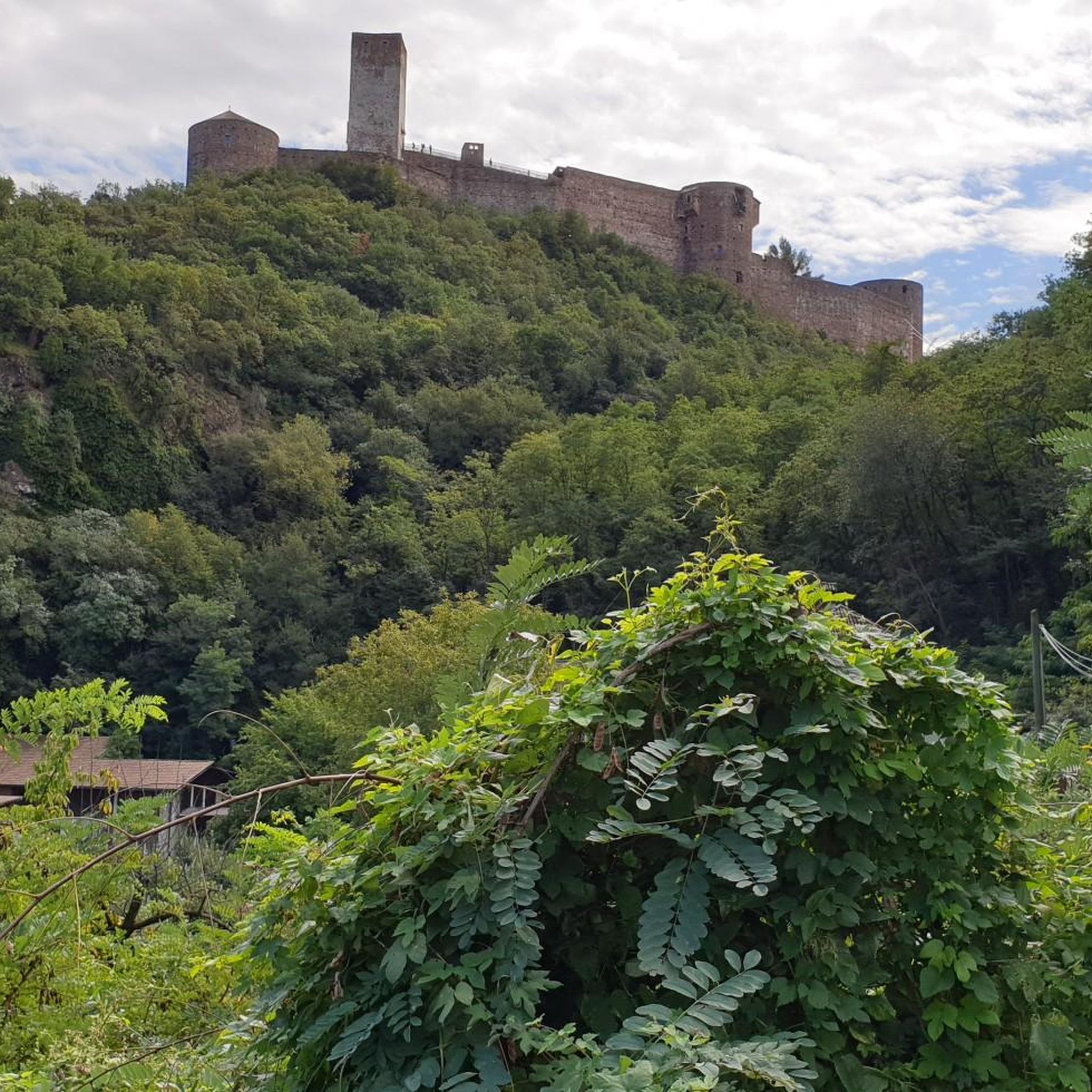
On the banks of Lough Neagh, near the village of Brockagh, you will find the impressive ruin of Mountjoy Castle. This castle was built between 1602 and 1605 by Lord Mountjoy and served at the time as a crucial military stronghold during the turbulent years of the Nine Years' War. Unique is the special combination of building materials: the lower floor is constructed from rough natural stone, while the upper floor consists of locally fired red brick. Although the castle has been a ruin since 1648, the central block and the characteristic arrow-shaped corner towers are still clearly recognizable in the landscape.
8
0
Small, cozy coffeeshop in the center of Beltrim, housed in an old bank building. Known as a quiet stopover for cyclists in the Sperrin region, with good coffee, cakes, and a friendly atmosphere. Located close to the river, it forms a logical break point on routes between Omagh, Gortin, and the Sperrins hills.
8
0

In the shadow of Northern Ireland's vast skies, the mysterious Mountjoy Castle rises on a hill above Lough Neagh. This ruined castle, whose Irish name "Caisleán Mhuinseo" whispers into the wind, stands like a proud sentinel in the village of Mountjoy, County Tyrone. The castle was built in 1602 by order of Charles Blount, 1st Earl of Devonshire and 8th Baron Mountjoy. But times have not always been kind to this building: as early as 1643, a devastating fire left scars on the walls of the castle. What remained is a two-story brick building with the ground floor clad in stone. The architecture speaks of a time of defense and vigilance - a central rectangular block protected by four spear-shaped towers, crisscrossed by embrasures. The north-western tower testifies to the fragility of time - partially collapsed, while the western curtain wall has lost its presence. The entrance, once on the south side of the eastern curtain wall, seems to whisper stories of days gone by, while wide windows on the upper floor capture the eyes of visitors. Unfortunately, an extension at the back keeps some of the castle's secrets hidden, and the interior area is closed to visitors' eyes. But even in its ruined state, Mountjoy Castle embodies the soul and history of Northern Ireland. Not only is it a State Care Historic Monument in the townland of Magheralamfield in the Mid Ulster District, but it is also a silent testament to time, inviting every walker to pause for a moment and listen to the whispers of history.
4
0
As you step through the magnificent gate, you will be enveloped by the timelessness of this historic place. The old walls, which shine in the sun, tell stories from times long past and invite you to discover them. The municipality has enriched this treasure trove of history with a library and a museum that attract knowledge seekers and history lovers. In the quiet rooms of the library you can leaf through old writings and be transported back to times gone by, while the museum brings the history of the place and its people to life. After a journey of discovery through history and culture, the Priorat's café beckons with its seductive scent of freshly brewed coffee. Here, in an ambience that wonderfully combines modernity and history, you can take a little time out. Choose from comfortable seating inside or settle on one of the terraces to soak up the rays while munching on delicious pastries. But the Priory has even more to offer. A dreamy little walkway winds from the building down to the river. A path lined with blooming flowers and old trees that acts as an invitation to explore this wonderful terrain in all its splendor.
2
0

Brantry Lough is a fantastic fishing lake situated just north of Creevelough in County Tyrone. The waters provide a great supply of brown trout that's stocked all year around bringing keen fishermen and their boats to the shores
0
0

Omagh is the county town of County Tyrone which plays host to a number of festivals and events throughout the year. A market town, there are plenty of places to stop to eat or drink and you can't fail to notice the twin spires of Sacred Heart Church.
2
0

Nice little cafe at Benburb Priory. Well worth a stop if you are in the area.
0
0
The church ruins date from the early 16th century but include stones from a much earlier pre 11th century church. After a new church was built, this one fell into disrepair, but the graveyard remains in use.
0
0
Frequently Asked Questions
How many road cycling routes are available in Cratley?
There are over 110 road cycling routes available around Cratley, catering to various skill levels. You'll find a mix of easy, moderate, and challenging rides to explore the region's diverse landscapes.
Are there routes suitable for beginners or families?
Yes, Cratley offers routes suitable for beginners and families. The town itself is largely flat with quiet streets and dedicated cycle tracks. For a gentler experience, consider routes like the Mountjoy Castle loop from Cookstown, which features moderate climbs but is generally accessible. The Worth Way, part of National Cycle Network Route 21, also provides a relatively flat and traffic-free option.
What kind of terrain can I expect on road cycling routes around Cratley?
Road cycling around Cratley offers a mix of rolling terrain and open landscapes. While the immediate vicinity of Cookstown presents varied topography, the broader area includes significant climbs, especially as you venture towards the High Weald National Landscape. You can expect moderate elevation gains, routes traversing agricultural areas, and scenic views of natural features like Lough Neagh.
Are there challenging routes for experienced cyclists?
Absolutely. For experienced cyclists seeking a challenge, routes like the Drum Manor House Ruins – Brantry Lough loop from Cookstown offer over 1000 meters of elevation gain over 126 kilometers. The nearby High Weald and Surrey Hills AONBs also feature more demanding ascents, including famous climbs like Box Hill and Leith Hill, providing ample opportunity for a strenuous ride.
Can I find routes with scenic viewpoints?
Many routes around Cratley offer scenic viewpoints. The Lough Neagh – View of Lough Neagh loop from Cookstown, for instance, provides beautiful vistas of Lough Neagh and the surrounding countryside. As you cycle through the High Weald, you'll encounter rolling hills and dense woodlands, offering picturesque views of the historic farmland.
Are there any circular road cycling routes?
Yes, many of the road cycling routes around Cratley are designed as circular loops, allowing you to start and end at the same point. Examples include the Mountjoy Castle loop from Cookstown and the Lough Neagh – View of Lough Neagh loop from Cookstown. These loops are convenient for exploring the area without needing to retrace your path.
What are some notable attractions or landmarks I might see along the way?
While cycling around Cratley, you might encounter historical sites such as Mountjoy Castle. The broader region also offers attractions like Nymans, a National Trust property with historic gardens, and Hever Castle, the childhood home of Anne Boleyn. Routes often pass through charming villages with country pubs, adding to the local experience.
Where can I find parking for road cycling routes in Cratley?
Parking is generally available in and around Cratley, particularly in town centers or designated car parks near popular starting points for routes. For specific parking information related to routes originating from Cookstown, it's advisable to check local council websites or route descriptions for details on nearby facilities. The Crawley Borough Council website provides information on local transport and access, which may include parking details: crawley.gov.uk.
Are there road cycling routes that pass by cafes or places to stop for refreshments?
Yes, many local road cycling routes around Cratley pass through villages like Charlwood and Rusper, which often feature country pubs and cafes where you can stop for refreshments. Longer routes, especially those venturing into the High Weald, may also have options in market towns or smaller hamlets along the way.
What is the best time of year for road cycling in Cratley?
The best time for road cycling in Cratley is typically from spring through early autumn (April to October) when the weather is milder and daylight hours are longer. During these months, you'll experience the most pleasant conditions for exploring the open countryside and enjoying the scenic views.
How does Cratley connect to larger cycling networks?
Cratley is well-connected to larger cycling networks. The Worth Way, part of National Cycle Network Route 21, connects Crawley to East Grinstead. Route 21 also forms part of the international Avenue Verte London to Paris route, passing through Gatwick and leading to Newhaven for the ferry to Dieppe. Additionally, the region is close to the Wealdway route and offers access to the extensive networks within the High Weald and Surrey Hills National Landscapes.
Are there options for longer distance road cycling?
Yes, Cratley offers excellent options for longer distance road cycling. Routes like the Sacred Heart Church, Omagh – Omagh Town Centre loop from Cookstown extend for nearly 100 kilometers, providing a substantial ride. For even longer adventures, you can link up with sections of the National Cycle Network or explore the extensive routes within the High Weald and Surrey Hills AONBs.
Most popular routes around Cratley

Get inspired with the komoot mobile app


Explore more
Browse the best Road cycling routes in other regions.
