The best road cycling routes around Saelices De La Sal
33
riders
9
rides
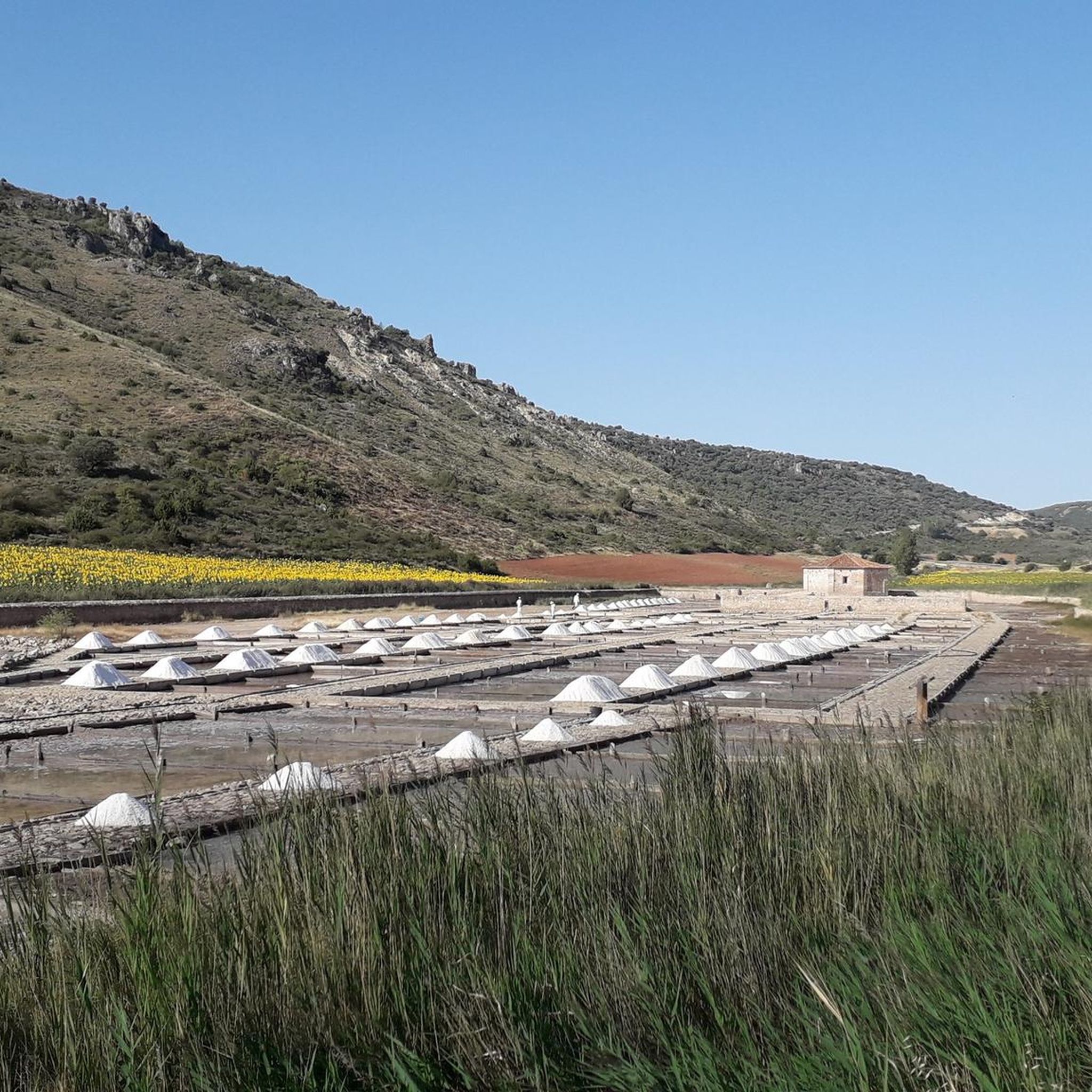
Road cycling routes around Saelices De La Sal traverse a landscape characterized by a narrow valley and surrounding hills, offering varied terrain for cyclists. The region, situated in the province of Guadalajara, Spain, features scenic roads through oak and pine forests. It lies within the peripheral zone of the Alto Tajo Natural Park, providing a natural setting for exploration.
Best road cycling routes around Saelices De La Sal
- The most popular road cycling route is Alcolea del Pinar – Anguita…
Last updated: July 11, 2026
6
riders
Moderate road ride. Good fitness required. Mostly well-paved surfaces and easy to ride.
5
riders
39.4km
01:57
630m
630m
Moderate road ride. Good fitness required. Mostly well-paved surfaces and easy to ride.

Sign up for free
6
riders
87.2km
04:11
1,160m
1,160m
Hard road ride. Very good fitness required. Some segments of this route may be unpaved and difficult to ride.
4
riders
105km
04:51
1,250m
1,250m
Hard road ride. Very good fitness required. Mostly well-paved surfaces and easy to ride.
6
riders
31.6km
01:38
580m
580m
Moderate road ride. Good fitness required. Mostly well-paved surfaces and easy to ride.
Get access to more routes and recommendations from other explorers.
Sign up for free
Already have an account?
Our route recommendations are based on thousands of hikes, rides, and runs completed by other people on komoot.
Start today with a free account
Your next adventure awaits.
Login or Signup
Popular around Saelices De La Sal
Tips from the Community

Fresh water source on the outskirts of the village of Ciruelos del Pinar.
0
0
First checkpoint on the route from Madrid to Barcelona. In the main square we find places to get supplies and rest.
0
0

Extraordinary town, on the banks of the Tajuña River, full of history. From its Celtiberian Castros through its Roman Camps, to its Cuevas del Cid and its Muslim towers. Nearby is one of the most characteristic Dolmens of the plateau, the Portillo del Cortes Dolmen. There were also menhirs although with the concentration of land they disappeared. Its churches are also of extraordinary value. Its very welcoming people.
1
0

Tortonda is a small town belonging to the municipality of Guadalajara, in the autonomous community of Castilla-La Mancha. Views of the city, with its tower, make a pleasant detour along the road.
0
0

The Torresaviñán castle, from the 12th century, is located on a hill very close to Torremocha del Campo and is visible from the Barcelona highway itself. It is of Muslim origin and due to the absence of amenities in its structure, it is assumed that it was a defensive post, rather than a permanent settlement. Its current state is due to the blowing up of its walls by the Austrian army during the war of succession in the 18th century.
0
0

Unknown town but with a lot of charm. The Tajuña pass stands out with its orchards, the cave where they say the Cid Campeador spent the night in his exile, and its tower on top of the rocky outcrops.
0
1

The Valtablado del Río bridge crosses the waters of the Tagus in an area full of poplars. The great width and shallowness of the river, added to the shade provided by the trees, creates a privileged bathing area on hot days.
2
0
Moranchel is a small hamlet in the Alcarreña town of Cifuentes. It is located on the route of the Ruta de la Lana and has a curious historic center that is currently decorated with murals on the houses.
0
0
Frequently Asked Questions
What is the typical terrain and difficulty for road cycling in Saelices de la Sal?
Road cycling routes around Saelices de la Sal traverse a landscape characterized by a narrow valley and surrounding hills. You'll find varied terrain, including scenic roads through oak and pine forests. The routes range from moderate, with elevation gains around 1,300 feet (400 meters), to difficult, featuring significant climbs of over 3,700 feet (1,150 meters) on longer trails. This offers options for different ability levels.
What natural features and landmarks can I expect to see while road cycling in the region?
The region is part of the peripheral zone of the Alto Tajo Natural Park, offering a natural setting. You can expect picturesque views of the 'Valle de los milagros' and ride through oak and pine forests. Notable landmarks include the historic Cueva de los Casares, an important archaeological site with Paleolithic engravings, and the unique Salinas de San Juan, the only operational saltworks in central Spain.
Are there any historical sites accessible by road bike near Saelices de la Sal?
Yes, several historical sites are within reach. The Salinas de San Juan, with their artisanal salt extraction process and the neoclassical hermitage of Nuestra Señora del Salero, are a primary attraction. Additionally, the Cueva de los Casares, known for its prehistoric engravings, is very close to Saelices de la Sal and features an excavated Muslim settlement and an Arab watchtower nearby.
What are the typical distances of road cycling routes in the Saelices de la Sal area?
The road cycling routes in the area offer a range of distances. You can find moderate loops around 24.5 to 25.5 miles (39-41 km), such as the Ablanque loop from Saelices de la Sal. For more challenging rides, there are difficult routes extending up to 54.2 miles (87.3 km), like the Arrival in Sacecorbo – Cifuentes loop from Sacecorbo, and even longer at 64.7 miles (104.1 km).
When is the best time of year for road cycling in Saelices de la Sal?
While specific weather data isn't provided, the region's location in central Spain suggests that spring and autumn would generally offer the most pleasant conditions for road cycling. These seasons typically avoid the intense heat of summer and the colder temperatures of winter, providing comfortable riding weather for exploring the valleys and hills.
Are there any family-friendly road cycling options in Saelices de la Sal?
The guide primarily features moderate to difficult road cycling routes, which may be challenging for younger children or families seeking very easy, flat paths. However, the varied terrain means that some sections of the moderate routes might be suitable for older, experienced cycling families. Always check the route's elevation profile and distance before setting out with family members.
What are the parking options for cyclists in Saelices de la Sal?
While specific parking facilities for cyclists are not detailed, Saelices de la Sal is a small town. It is generally possible to find parking in or near the town center, especially if you are starting a route directly from there. For routes originating from nearby villages like Sacecorbo or Santa María del Espino, similar local parking options would likely be available.
How can I reach Saelices de la Sal using public transport with my bike?
Information on specific public transport links to Saelices de la Sal that accommodate bicycles is not readily available. Given its location as a small town in the province of Guadalajara, public transport options might be limited. It is advisable to check local bus schedules or regional train services to nearby larger towns and then consider cycling the remaining distance or arranging alternative transport.
What kind of views can I expect on road cycling routes around Saelices de la Sal?
Road cycling routes in this area offer beautiful panoramic views, particularly from higher elevations. You can expect vistas of the narrow valley, the historic saltworks, and the town itself. Routes like those ascending towards the 'Cueva del Campillo' (a hiking route that offers similar views) provide stunning perspectives of the surrounding natural landscape, including oak and pine forests and the distinctive 'Valle de los milagros'.
Are there any loop road cycling trails available in Saelices de la Sal?
Yes, many of the road cycling routes in the area are designed as loops, allowing you to start and end in the same location. Examples include the Alcolea del Pinar – Anguita Village and Church loop from Santa María del Espino and the Ablanque loop from Saelices de la Sal. These circular routes are convenient for exploration, bringing you back to your starting point.
What is the longest road cycling route available in the Saelices de la Sal area?
The longest road cycling route featured in this guide is the Alcolea del Pinar – Stone House loop from Sacecorbo. This difficult trail covers a distance of 64.7 miles (104.1 km) and includes over 4,000 feet (1,248 meters) of elevation gain, typically taking around 4 hours and 48 minutes to complete.
Most popular routes around Saelices De La Sal
Most popular attractions around Saelices De La Sal

Get inspired with the komoot mobile app


Explore more
Browse the best Road cycling routes in other regions.
