The best running trails around Saint-Mamet-La-Salvetat
4.6
(54)
2,836
runners
16
runs
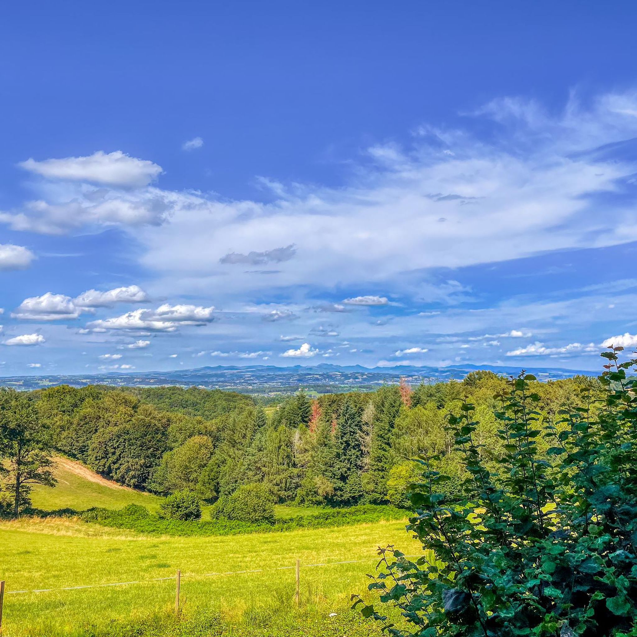
Jogging routes around Saint-Mamet-La-Salvetat offer varied terrain across the Châtaigneraie Cantalienne region. The area features volcanic scenery with views of the Cantalian peaks, including Puy Saint-Laurent, alongside lush valleys and dense forests. Runners can also find routes with views of Lac de Saint-Étienne-Cantalès, providing a mix of natural environments.
Best jogging routes around Saint-Mamet-La-Salvetat
- The most popular jogging route is Running loop from Aurillac, an 8.4 miles (13.5 km) trail that takes 1 hour 41 minutes to complete, offering…
Last updated: July 13, 2026
11
runners
13.5km
01:42
340m
340m
Hard run. Very good fitness required. Mostly paved surfaces. Suitable for all skill levels.
9
runners
9.66km
01:11
180m
180m
Moderate run. Good fitness required. Mostly paved surfaces. Suitable for all skill levels.

Sign up for free
6
runners
8.61km
00:58
130m
130m
Moderate run. Good fitness required. Mostly paved surfaces. Suitable for all skill levels.
4
runners
23.2km
02:43
470m
470m
Hard run. Very good fitness required. Mostly paved surfaces. Suitable for all skill levels.
3
runners
14.1km
01:31
240m
240m
Moderate run. Good fitness required. Mostly paved surfaces. Suitable for all skill levels.
Get access to more routes and recommendations from other explorers.
Sign up for free
Already have an account?
Our route recommendations are based on thousands of hikes, rides, and runs completed by other people on komoot.
Start today with a free account
Your next adventure awaits.
Login or Signup



Tips from the Community

360° view of the Monts du Cantal from the heights of the village of Saint Mamet La Salvetat. There is a small chapel there, as well as a Calvary, games for children and picnic tables.
1
0
Frequently Asked Questions
How many running routes are available around Saint-Mamet-La-Salvetat?
There are over 15 dedicated running routes around Saint-Mamet-La-Salvetat listed on komoot, offering a variety of distances and difficulty levels to explore the Châtaigneraie Cantalienne region.
What kind of scenery can I expect on the jogging trails in this region?
Jogging routes in Saint-Mamet-La-Salvetat offer diverse and dramatic scenery. You can expect stunning volcanic landscapes with panoramic views of the Cantalian peaks like Puy Saint-Laurent, Puy Mary, and Plomb du Cantal. Many trails also wind through lush valleys, dense oak, beech, and hornbeam forests, and some provide remarkable views of Lac de Saint-Étienne-Cantalès.
Are there any challenging running trails for experienced runners?
Yes, for experienced runners seeking a challenge, there are several difficult routes. One such option is the Running loop from Aurillac, which covers 8.4 miles (13.5 km) with significant elevation changes. Another demanding trail is the Panorama du Puy Saint Lauent loop from Saint-Mamet-la-Salvetat, a 9.0-mile (14.5 km) route through volcanic terrain.
What do other runners say about the trails in Saint-Mamet-La-Salvetat?
The running routes in Saint-Mamet-La-Salvetat are highly rated by the komoot community, with an average score of 4.5 stars from over 50 reviews. Runners often praise the varied terrain, the beautiful volcanic landscapes, and the well-maintained paths that offer a mix of moderate and challenging options.
Are there any family-friendly jogging routes in the area?
While specific 'family-friendly' designations aren't always available for jogging, many of the moderate routes with less elevation gain can be suitable for families who enjoy running together. The region's emphasis on nature and outdoor leisure means there are many paths that are generally accessible. Consider routes that explore the local countryside, such as the Running loop from Saint-Mamet-la-Salvetat, which is 5.3 miles (8.6 km) and moderate in difficulty.
Can I bring my dog on the running trails?
The natural landscapes and extensive network of trails in the Châtaigneraie Cantalienne region generally welcome dogs, provided they are kept on a leash and you adhere to local regulations regarding pet waste. It's always a good idea to check specific trail signage for any restrictions, especially in protected natural areas.
Are there any circular running routes available?
Yes, many of the running routes around Saint-Mamet-La-Salvetat are designed as loops, allowing you to start and finish at the same point. Examples include the Running loop from Saint-Mamet-la-Salvetat and the Étang de Vic loop from Saint-Mamet-la-Salvetat, which offers lakeside views.
What interesting landmarks or attractions can I see along the jogging routes?
Many running routes offer glimpses of the region's charm. You might pass by the medieval village of Marcolès or enjoy views of the Romanesque chapel atop Puy Saint-Laurent. Other notable points of interest nearby include the Moulin d'Entraygues and the unique Himalayan suspension bridge at Lake Cantalès.
Are there any running routes that offer views of Lac de Saint-Étienne-Cantalès?
Yes, the proximity to Lac de Saint-Étienne-Cantalès means several routes offer beautiful lakeside views. The Étang de Vic loop from Saint-Mamet-la-Salvetat is a moderate 5.1-mile (8.2 km) route that provides opportunities for lakeside running and views of the surrounding Cantal mountains.
What is the best time of year for running in Saint-Mamet-La-Salvetat?
The region's mild climate makes it suitable for running for much of the year. Spring and autumn offer pleasant temperatures and vibrant natural colors, while summer provides warm, sunny conditions, though it's advisable to run in the mornings or evenings to avoid the midday heat. The dense woods along the Cère Valley and Gorges de la Cère can provide welcome shade during warmer months.
Are there any easy or beginner-friendly running paths?
While there are no routes specifically marked as 'easy' in the provided data, many of the 'moderate' routes are suitable for beginners looking for a gentle introduction to trail running. These routes typically have less extreme elevation changes. The Running loop from Saint-Mamet-la-Salvetat is a moderate 5.3-mile (8.6 km) path that explores the local countryside and could be a good starting point.
Is public transport available to access the running trails?
Saint-Mamet-La-Salvetat is a rural commune in the Cantal region. While local bus services might connect some villages, direct public transport access to specific trailheads can be limited. It's generally recommended to have personal transportation to reach the starting points of many running routes, especially those outside the main village.
Where can I find parking near the running routes?
Most running routes that start from villages like Saint-Mamet-La-Salvetat or Aurillac will have designated parking areas within or on the outskirts of the town. For routes starting in more remote natural areas, look for small parking lots or roadside pull-offs near trailheads. Always ensure you park responsibly and do not obstruct local access.
Most popular routes around Saint-Mamet-La-Salvetat
Most popular attractions around Saint-Mamet-La-Salvetat

Get inspired with the komoot mobile app


Explore more
Browse the best Running Trails & Routes in other regions.
