The best road cycling routes around Parigné
4.4
(37)
2,021
riders
480
rides
Road cycling routes around Parigné offer a diverse and well-preserved natural landscape, characterized by extensive woodlands covering over 50% of the commune's surface. The terrain is often described as "well-hilly," providing engaging climbs and descents for road cyclists. This region features numerous undergrowths, vast moors, and ponds, creating varied backdrops for rides. An extensive network of cycling paths, including greenways and shared paths, connects natural features and local attractions.
Best road cycling routes around Parigné
- The most popular road cycling…
Last updated: July 5, 2026
39
riders
107km
05:02
950m
950m
Hard road ride. Very good fitness required. Mostly well-paved surfaces and easy to ride.
5.0
(1)
21
riders
87.5km
03:41
520m
520m
Moderate road ride. Good fitness required. Some segments of this route may be unpaved and difficult to ride.

Sign up for free
16
riders
86.7km
03:38
510m
510m
Moderate road ride. Good fitness required. Mostly well-paved surfaces and easy to ride.
5.0
(1)
14
riders
62.8km
02:41
450m
450m
Moderate road ride. Good fitness required. Mostly well-paved surfaces and easy to ride.
9
riders
67.5km
02:50
430m
430m
Moderate road ride. Good fitness required. Mostly well-paved surfaces and easy to ride.
Get access to more routes and recommendations from other explorers.
Sign up for free
Already have an account?
Our route recommendations are based on thousands of hikes, rides, and runs completed by other people on komoot.
Start today with a free account
Your next adventure awaits.
Login or Signup

Tips from the Community

From there it looks the strongest !!!
0
0

Parts of the route along the sea do not exist or are forbidden for bicycles
0
0

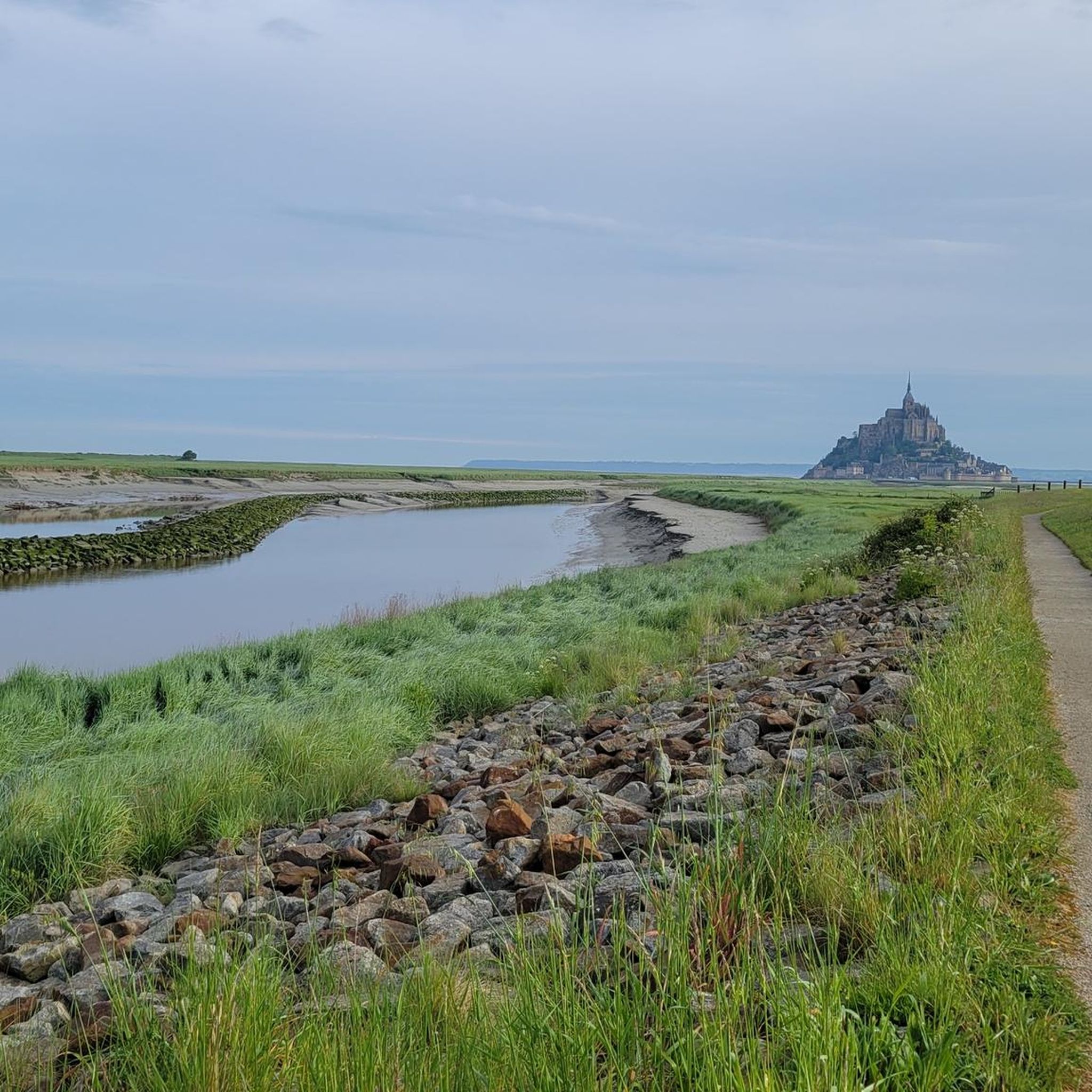
Old priory attached to Mont Saint Michel, the ultimate stage for pilgrims before the Merveille.
0
0

If there's a remarkable site that's worth a detour, it's Mont St Michel!
0
0

Antrain is a charming Breton village nestled between the Couesnon and Loysance rivers. The area is popular with hikers for its natural setting of hedged fields and marshes. Visitors can discover a remarkable heritage, including the Church of Saint-André and the Château de Bonnefontaine, as well as pretty old streets.
0
0

Go at low or high tide
1
0

small park, with plenty of seating by the river
1
0
Frequently Asked Questions
How many road cycling routes are available around Parigné?
Parigné offers a wide selection of road cycling routes, with nearly 500 tours available. This includes a diverse range of options, from easier rides to challenging routes with significant elevation gains.
What kind of terrain can I expect on road cycling routes in Parigné?
The terrain around Parigné is often described as 'bien vallonné' (well-hilly), providing engaging climbs and descents. You'll find routes through extensive woodlands, vast moors, and picturesque ponds. While most surfaces are paved, some segments might include unpaved sections, offering variety for riders interested in mixed terrain.
Are there road cycling routes suitable for beginners or those looking for an easier ride?
Yes, Parigné caters to various skill levels. While many routes feature engaging hills, there are 52 routes classified as easy and over 400 moderate options. These routes allow you to enjoy the scenic landscapes without overly strenuous climbs.
What are some notable natural features or landscapes to see while cycling in Parigné?
Parigné is known for its natural heritage, with over 50% of its surface covered by woodlands. You can cycle past the significant Loudon Ponds, recognized for their ecological importance, or explore routes extending into the vast Forest of Bercé. The Basse Goulandière Regional Nature Reserve also offers unique flora and fauna.
What historical or cultural landmarks can I discover along the road cycling routes?
The region boasts several historical and cultural points of interest. You might pass by the exteriors of châteaux like Montbraye and la Vaudère, or the Javron tower. Nearby, you can visit the impressive Fougères Castle, the historic Place du Marchix with its half-timbered houses, or the Belfry of Fougères. The Notre-Dame-de-Pitié chapel and the Lantern of the Dead are also listed as Historic Monuments in the area.
Are there any family-friendly cycling options or places to visit near the routes?
While many road cycling routes are geared towards fitness, the region offers family-friendly attractions. The Plan d'eau de Parigné is a local leisure area with a body of water, perfect for walks, fishing, mini-golf, and picnics, accessible via 'voie douces' (gentle paths). The Arche de la Nature, a large natural park near Le Mans, is also connected by cycling routes and offers trails, rivers, and lakes for exploration.
What do other road cyclists enjoy most about cycling in Parigné?
The road cycling routes in Parigné are highly rated by the komoot community, with an average score of 4.0 stars from over 33 reviews. Cyclists often praise the diverse and well-preserved natural landscapes, the engaging 'well-hilly' terrain, and the extensive network of paths that connect natural features and local attractions.
Are there any challenging road cycling routes for experienced riders?
Yes, for experienced riders seeking a challenge, there are 31 routes classified as difficult. These routes feature significant elevation gains and longer distances. An example is the Savigny Abbey (ruins) – Old Town of Mellouen loop from Villamée, which covers over 113 km with substantial climbing.
Can I find circular road cycling routes in Parigné?
Many of the road cycling routes in Parigné are designed as loops, allowing you to start and finish in the same location. For instance, the popular Fougères Castle – View of Mont Saint-Michel loop from Lécousse is a moderate 87.5 km circular path offering scenic views and varied terrain.
What are some longer road cycling routes available in the area?
For those looking for longer rides, Parigné offers several extensive routes. The Roadbike loop from Villamée is a difficult 105 km trail with significant elevation. Another option is the Fougères Castle loop from Landéan, a moderate 89 km route.
Are there routes that offer views of Mont Saint-Michel?
Yes, some routes in the broader region offer distant views of Mont Saint-Michel. The Fougères Castle – View of Mont Saint-Michel loop from Lécousse is a moderate route that provides scenic views, including glimpses of this iconic landmark.
What is the best time of year for road cycling in Parigné?
While specific seasonal data isn't provided, the region's 'bien vallonné' terrain and extensive woodlands suggest that spring and autumn would offer pleasant temperatures and beautiful scenery. Summer can also be enjoyable, especially when cycling through the shaded forest areas. Always check local weather conditions before heading out.
Most popular attractions around Parigné

Get inspired with the komoot mobile app


Explore more
Browse the best Road cycling routes in other regions.
