The best cycling routes around Champniers-Et-Reilhac
4.5
(30)
186
riders
80
rides
Touring cycling around Champniers-Et-Reilhac offers routes through the varied topography of the Dordogne department, with elevations ranging from 185 to 360 meters. The region is characterized by rolling roads, chestnut woods, and picturesque stone villages, providing a scenic backdrop for cycling. Located within the Périgord Limousin Regional Natural Park, the area features valleys and bocage, contributing to its natural heritage. These Champniers-Et-Reilhac cycling routes provide a mix of terrain suitable for different cycling preferences.
Best touring cycling routes around Champniers-Et-Reilhac
…Last updated: July 2, 2026
5.0
(1)
1
riders
35.3km
02:21
430m
430m
Moderate bike ride. Good fitness required. Mostly paved surfaces. Suitable for all skill levels.
2
riders
17.4km
01:10
200m
190m
Hard bike ride. Good fitness required. You may need to push your bike for some segments of this route.

Sign up for free
4
riders
Moderate bike ride. Good fitness required. Mostly paved surfaces. Suitable for all skill levels.
5.0
(1)
2
riders
36.5km
02:23
440m
440m
Moderate bike ride. Good fitness required. Mostly paved surfaces. Suitable for all skill levels.
2
riders
49.1km
03:07
580m
580m
Hard bike ride. Very good fitness required. Mostly paved surfaces. Suitable for all skill levels.
Get access to more routes and recommendations from other explorers.
Sign up for free
Already have an account?
Our route recommendations are based on thousands of hikes, rides, and runs completed by other people on komoot.
Start today with a free account
Your next adventure awaits.
Login or Signup



Tips from the Community

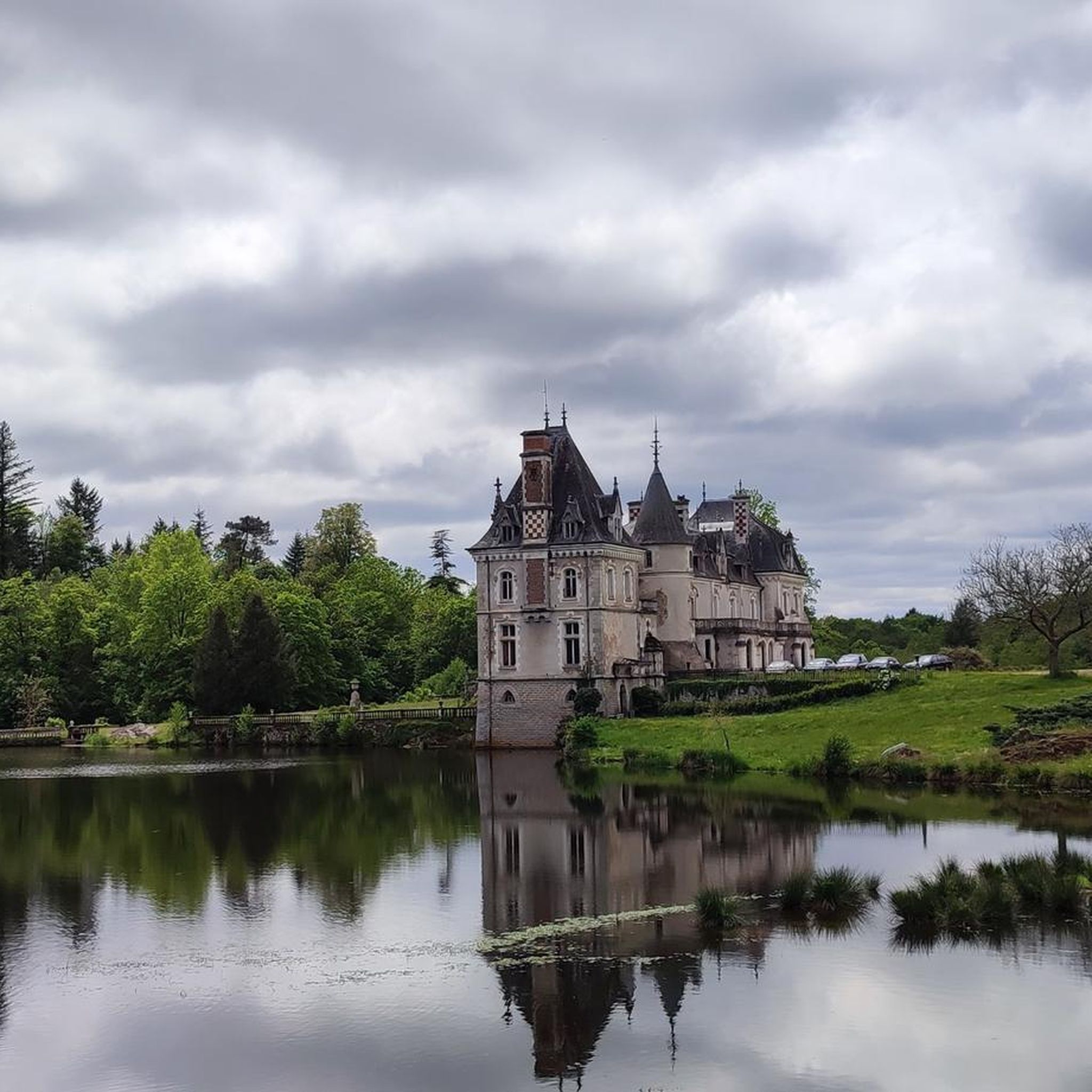
Javerlhac Castle was rebuilt around 1498 by Dauphin Pastoureau, a master blacksmith in Nontron. It is typical of Périgord manor houses, with a rectangular dwelling, a large round tower with machicolations decorated with trefoils, and a polygonal tower housing a spiral staircase. The castle retains defensive features such as gun ports, despite modernization in the early 19th century. It burned down in 1369 during the Hundred Years' War and has undergone several reconstructions. Privately owned, its facades and roofs have been listed as historic monuments since 1974.
2
0
Real collector's items!
0
0

Beautiful walk around the lake
0
0

Under the rock, you can also try to insert your mother-in-law, guaranteed effect 👍🦆👙🦐🎸🥂
0
0

A very beautiful mill near Javerlhac-et-la-Chapelle-Saint-Robert on the river Bandiat.
4
0

Very beautiful castle. Unfortunately you can only visit it from the outside
1
0

beautiful bike tour across country
1
0
Beautiful swimming lake. Highly recommended
2
0
Frequently Asked Questions
What is the overall difficulty level of touring cycling routes around Champniers-Et-Reilhac?
The touring cycling routes in Champniers-Et-Reilhac offer a good mix of challenges. Out of 80 available routes, 8 are considered easy, 34 are moderate, and 38 are difficult. This varied topography, with elevations ranging from 185 to 360 meters, ensures options for different cycling preferences and fitness levels.
What kind of terrain can I expect when touring cycling in this region?
You can expect a diverse landscape characterized by rolling roads, picturesque stone villages, and extensive chestnut woods. The area is nestled within the Périgord Limousin Regional Natural Park, featuring valleys and bocage, which contribute to its natural beauty and varied terrain.
Are there any circular touring cycling routes available?
Yes, many touring cycling routes around Champniers-Et-Reilhac are designed as loops, allowing you to start and finish in the same location. For example, the Roman Road – Javerlhac Castle loop from Piégut-Pluviers and the Roman Road – The Rocking Stone loop from Piégut-Pluviers are popular circular options.
What natural attractions can I discover along the touring cycling routes?
The region is rich in natural beauty. You can cycle past serene lakes like the Grand Etang de St-Estèphe and the Étang de Saint-Estèphe. A notable natural monument is The Rocking Stone near Saint-Estèphe, which you can explore on routes like the Roman Road – The Rocking Stone loop from Piégut-Pluviers. Other highlights include Saint-Estèphe Pond Beach and the Devil's Rosary Rocks.
Are there any historical or cultural landmarks to see while cycling?
Absolutely. The area is dotted with historical sites. You can visit local churches like Saint-Paul de Reilhac and discover charming stone villages. Routes like the Roman Road – Javerlhac Castle loop from Piégut-Pluviers will take you past historical paths and local landmarks, including castles such as Brie Castle and the Château de Ballerand.
Is Champniers-Et-Reilhac suitable for family-friendly touring cycling?
Yes, the region offers options for family-friendly touring. While some routes have rolling hills, the broader Dordogne Valley features 'Voies Vertes' (Greenways) which are car-free paths, perfect for a safe and scenic adventure with children. These paths wind through charming towns and offer views of historic castles.
What is the best time of year for touring cycling in Champniers-Et-Reilhac?
The region benefits from a sunny climate, making spring, summer, and early autumn ideal for touring cycling. Spring offers lush greenery and pleasant temperatures, while summer provides warm, long days. Early autumn brings beautiful foliage and cooler, comfortable cycling conditions.
What do other touring cyclists enjoy the most about touring cycling in Champniers-Et-Reilhac?
The area is highly rated by the komoot community, with an average score of 4.5 stars from over 30 reviews. Cyclists often praise the quiet, traffic-free roads, the picturesque scenery of chestnut woods and stone villages, and the varied terrain that keeps rides interesting. The presence of historical landmarks and natural features like 'Le Roc Branlant' also adds to the appeal.
Are there longer touring cycling routes for multi-day adventures?
Beyond the local loops, Champniers-Et-Reilhac serves as an excellent base for accessing longer regional routes. You can connect to sections of the 'Richard Lionheart West Bike Loop' (152 km), the 'Saint-Jacques à Vélo' (Vézelay route, 422 km), or 'La Vélidéale' (V93), which guides cyclists through the old Limousin Region. These routes offer opportunities for multi-day touring.
Where can I find parking for my car when starting a touring cycling route?
Many of the touring cycling routes around Champniers-Et-Reilhac, especially those starting from towns like Piégut-Pluviers or Saint-Barthélemy-de-Bussière, typically have designated parking areas available in or near the town centers. It's advisable to check local signage upon arrival for specific parking instructions.
Can I access touring cycling routes using public transport?
While Champniers-Et-Reilhac is a smaller commune, the broader Limousin and Dordogne regions have some public transport options. However, direct public transport access to specific trailheads might be limited. It's recommended to check local bus or train schedules for nearby larger towns and plan accordingly, as you might need to cycle a short distance to reach your desired starting point.
Are there any specific touring cycling routes that offer significant elevation gain?
Yes, given the region's rolling topography, several routes offer notable elevation gain. For instance, the Mailet loop from Piégut-Pluviers, a difficult 49.1 km route, features an elevation gain of approximately 584 meters, providing a good challenge for experienced touring cyclists.
Most popular routes around Champniers-Et-Reilhac
Most popular attractions around Champniers-Et-Reilhac

Get inspired with the komoot mobile app


Explore more
Browse the best Cycling routes in other regions.
