The best running trails around Englancourt
4.5
(2)
298
runners
51
runs
Jogging around Englancourt offers a serene experience through the picturesque landscapes of the Oise Valley and Thiérache bocage. The region is characterized by a mosaic of woodlands, hedgerows, and pastures, providing varied terrain for runners. Extensive agricultural lands and forests cover a significant portion of the area, ensuring tranquil, green spaces away from urban congestion. Several streams and the Oise River contribute to the lush environment, with routes often following flat, shaded paths alongside these waterways.
Best jogging routes around…
Last updated: October 16, 2026
20
runners
8.35km
00:52
40m
40m
Moderate run. Good fitness required. Mostly paved surfaces. Suitable for all skill levels.
14
runners
11.1km
01:08
30m
30m
Moderate run. Good fitness required. Mostly paved surfaces. Suitable for all skill levels.

12
runners
16.3km
01:41
60m
60m
Hard run. Very good fitness required. Mostly paved surfaces. Suitable for all skill levels.
5
runners
8.73km
00:56
110m
100m
Moderate run. Good fitness required. Mostly paved surfaces. Suitable for all skill levels.
4
runners
6.33km
00:40
60m
60m
Moderate run. Good fitness required. Mostly paved surfaces. Suitable for all skill levels.
Get access to more routes and recommendations from other explorers.
Already have an account?
Our route recommendations are based on thousands of hikes, rides, and runs completed by other people on komoot.
Start today with a free account
Your next adventure awaits.



Tips from the Community

The Ax Vert de la Thiérarche is a former railway line that has been converted into a cycling and walking path. The trail of almost 40 kilometers runs from Guise to Hirson, via Autreppes, and offers a pleasant and peaceful environment for walking, cycling and horse riding. The path runs along the banks of the Oise River and offers beautiful views of the natural and cultural heritage of the Thiérache.
2
0


Magnificent passage through the woods, and a pretty little village on the route.
2
0

Small pond on the old railway line. But scenic great place 😊
2
0

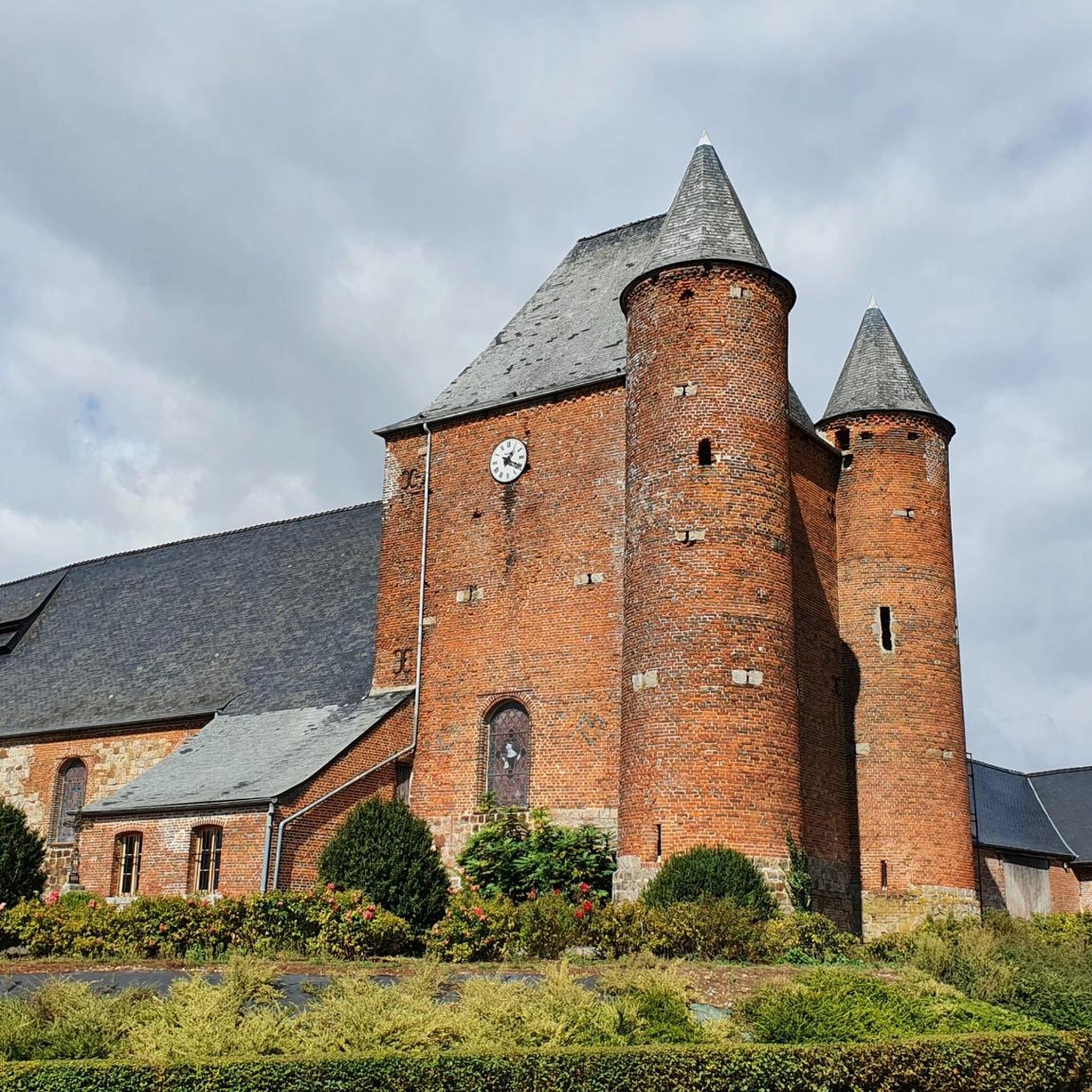
The fortified church of Saint Hilaire dates from 1632. It has been listed as a Historic Monument since 1989. It is particularly remarkable for its square bell tower-keep, which is flanked by 2 round turrets, all in brick covered with slate.
1
0
simply a mystical place!
2
1

The green axis is an old railway line on which a cycle path has been built, part of Euroveloroute N°3 which goes from Strondheim to Santiago de Compostela.
2
0
Frequently Asked Questions
How many running routes are available around Englancourt?
There are over 30 dedicated running routes around Englancourt, catering to various fitness levels. You'll find a good mix of easy, moderate, and challenging trails to explore the picturesque Oise Valley and Thiérache bocage.
What kind of terrain can I expect on the running trails in Englancourt?
The running trails in Englancourt offer a diverse landscape. You'll jog through the green Oise Valley, the charming Thiérache bocage with its mosaic of woodlands and pastures, and extensive agricultural lands and forests. Many routes also follow flat, shaded paths alongside the Oise River and smaller streams, providing a tranquil, rural setting.
Are there any easy running routes suitable for beginners or a relaxed jog?
Yes, Englancourt offers a few easy running routes perfect for beginners or those looking for a relaxed pace. For example, the Astrée Leisure Center – Joli chemin loop from Sale Pot is a moderate 5.2 km route that can be a great option to start with, offering pleasant scenery without significant elevation changes.
Are there any challenging routes for experienced runners?
Absolutely. For experienced runners seeking a challenge, the Old railroad loop from Marly-Gomont is a difficult 16.3 km path. This route follows a section of the Axe Vert de Thiérache, a former railway line converted into a dedicated trail, offering a longer and more demanding run.
What do other runners enjoy most about jogging in Englancourt?
The running routes in Englancourt are highly rated by the komoot community, with an average score of 4.0 stars. Reviewers often praise the serene experience through the picturesque landscapes, the variety of terrain from woodlands to river paths, and the peaceful, rural setting away from urban congestion.
Are there any notable landmarks or viewpoints along the running routes?
While jogging around Englancourt, you can enjoy several natural features and points of interest. The region is known for its panoramic views over the Oise Valley, particularly from the belvédère d'Englancourt. You might also encounter sections of the Axe Vert de la Thiérache, a converted railway line, or pass by the Old railroad itself, offering a glimpse into the area's history.
Are there any circular running routes available?
Yes, many of the running routes around Englancourt are designed as loops, allowing you to start and finish at the same point. For instance, the popular Saint-Hilaire Church loop from Marly-Gomont is a moderate 10.2 km circular trail offering scenic views.
Can I bring my dog on the running trails in Englancourt?
Generally, many outdoor trails in rural areas like Englancourt are dog-friendly. However, it's always recommended to keep your dog on a leash, especially when passing through agricultural lands or near livestock, and to check for any specific local regulations or signage on individual routes.
Is there parking available near the trailheads?
While specific parking details vary by trailhead, many routes around Englancourt, especially those starting from villages like Marly-Gomont, typically have accessible parking options. It's advisable to check the individual route descriptions on komoot for the most precise parking information.
What is the best time of year to go running in Englancourt?
Englancourt's mild climate makes it suitable for running throughout much of the year. Spring and autumn offer pleasant temperatures and beautiful scenery with blooming flowers or vibrant fall foliage. Summer can be enjoyable, especially on shaded paths along rivers, while winter runs can be picturesque, though some trails might be muddy or require appropriate gear.
Are there any running routes that are particularly good for families?
For families looking for a pleasant jog, routes that are shorter and have minimal elevation gain are ideal. While specific 'family-friendly' designations aren't always present, consider easier, well-maintained paths like sections of the Axe Vert de Thiérache, which offer flat surfaces away from traffic.
Are there any routes that pass by water features?
Yes, the region is drained by the Oise River and several smaller streams like the Ruisseau des Buissons. Many routes take advantage of these natural features, offering flat, shaded paths alongside the waterways. You might even find spots like the Oise Riverside Picnic and Swimming Spot near Autreppes, perfect for a post-run cool-down.
Most popular attractions around Englancourt

Get inspired with the komoot mobile app


Explore more
Browse the best Running Trails & Routes in other regions.
