The best walks and hikes around Colombiers
4.5
(274)
1,529
hikers
19
hikes
Hiking around Colombiers offers diverse landscapes, blending historical waterways with natural parklands. The region is characterized by the tranquil paths along the UNESCO-listed Canal du Midi, gentle hills, and proximity to the varied terrain of the Parc Naturel Régional du Haut-Languedoc. Hikers can explore a mix of flat, tree-lined routes and more undulating trails through vineyards and natural habitats.
Best hiking trails around Colombiers
- The most popular hiking route is Etang de Montady viewpoint – Malpas Tunnel loop from Colombiers…
Last updated: October 12, 2026
4.4
(19)
114
hikers
8.36km
02:14
100m
100m
Moderate hike. Good fitness required. Easily-accessible paths. Suitable for all skill levels.
4.7
(18)
88
hikers
5.33km
01:24
40m
40m
Easy hike. Great for any fitness level. Easily-accessible paths. Suitable for all skill levels.

5.0
(7)
40
hikers
Moderate hike. Good fitness required. Easily-accessible paths. Suitable for all skill levels.
4.4
(7)
9
hikers
3.29km
00:54
50m
50m
Easy hike. Great for any fitness level. Easily-accessible paths. Suitable for all skill levels.
4.5
(6)
8
hikers
Easy hike. Great for any fitness level. Easily-accessible paths. Suitable for all skill levels.
Get access to more routes and recommendations from other explorers.
Already have an account?
Our route recommendations are based on thousands of hikes, rides, and runs completed by other people on komoot.
Start today with a free account
Your next adventure awaits.

Tips from the Community

Clinging to the banks of the Canal du Midi, the village of Poilhes (pronounced Poïlle) immediately seduces with its tranquil charm and authenticity. Here, the canal is not just a backdrop: it shapes the soul of the village and makes it an essential stopover for both boaters and travelers curious about history and heritage.
0
0
The Canal du Midi, formerly the Royal Canal, is a 17th-century technical feat designed by Pierre-Paul Riquet to connect the Atlantic to the Mediterranean. Today, it is above all a place for relaxation and discovery, where heritage, nature, and conviviality meet.
0
0
At the place called « Le Malpas » (bad passage in Occitan), the Canal du Midi crosses a hill separating the valleys of the Aude and the Orb. The importance of the relief led Pierre-Paul Riquet to dig a 160 m long tunnel for the canal to pass through. It is the oldest navigation tunnel in Europe. Carried out in 1679-1680, this construction site is one of the most emblematic of Riquet's undertaking.
0
0
At the place called « Le Malpas » (bad passage in Occitan), the Canal du Midi crosses a hill that separates the valleys of the Aude and the Orb. The importance of the relief led Pierre-Paul Riquet to have a 160 m long tunnel dug for the passage of the canal. It is the oldest navigation tunnel in Europe. Carried out in 1679-1680, this construction site is one of the most emblematic of Riquet's undertaking.
0
0
The Canal du Midi, formerly the Royal Canal, is a 17th-century technical feat designed by Pierre-Paul Riquet to connect the Atlantic to the Mediterranean. Today, it is above all a place for relaxation and discovery, where heritage, nature, and conviviality meet.
0
0
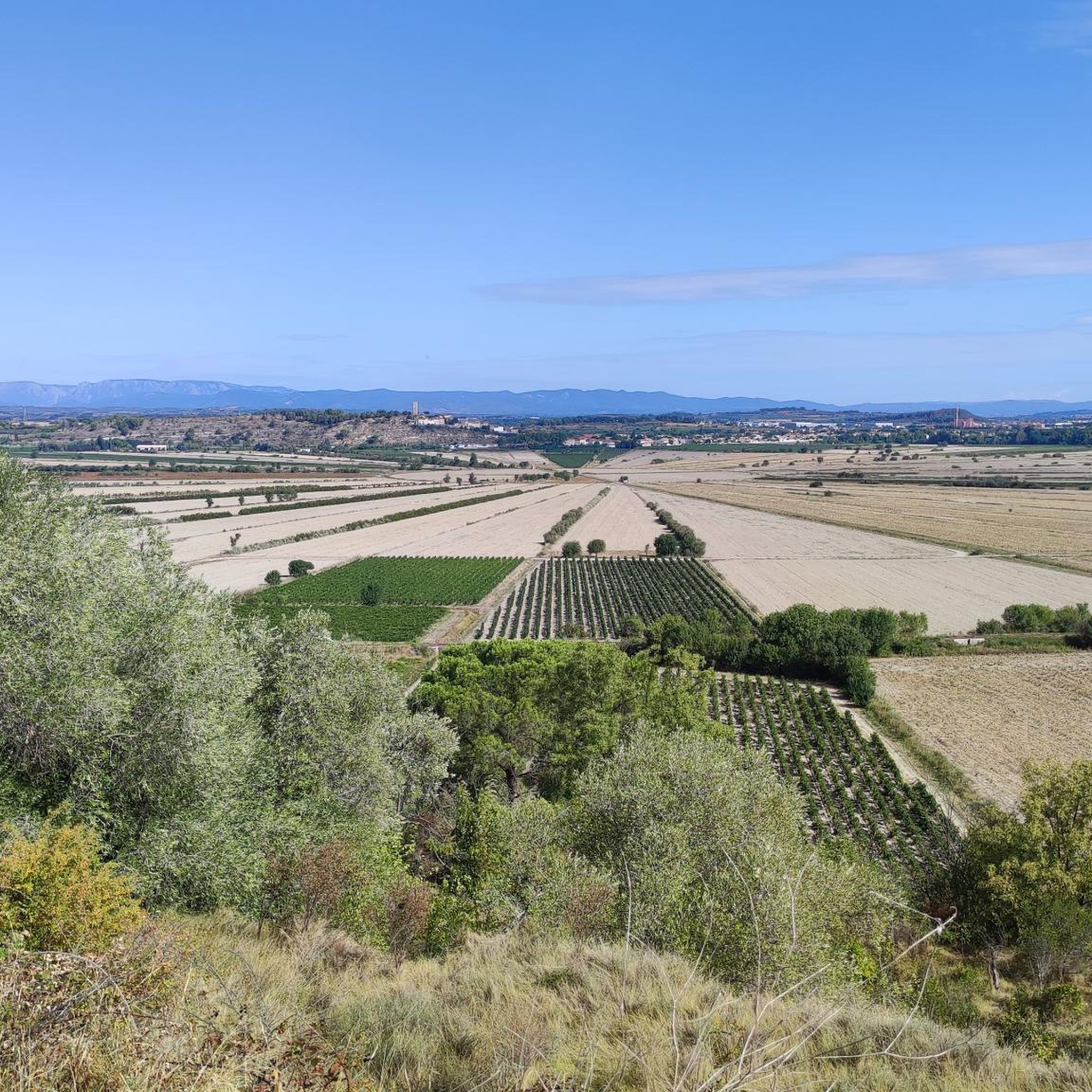
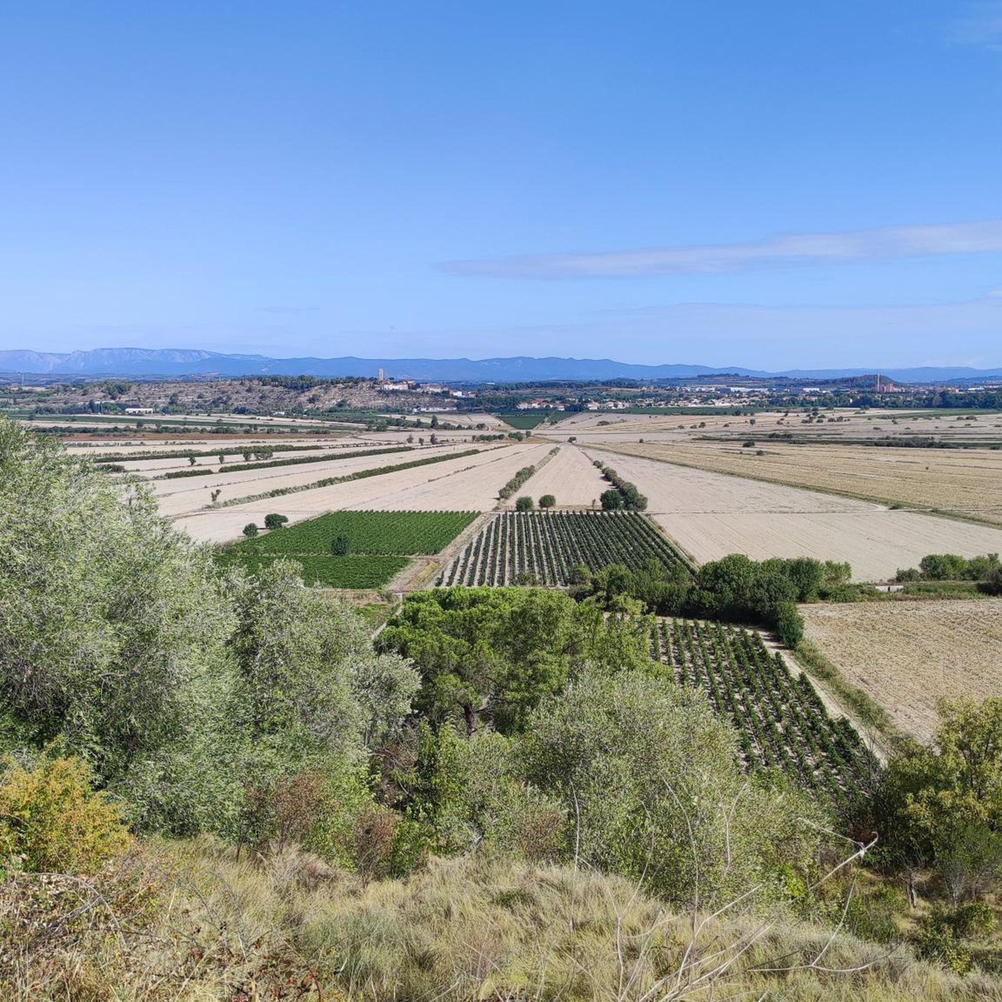
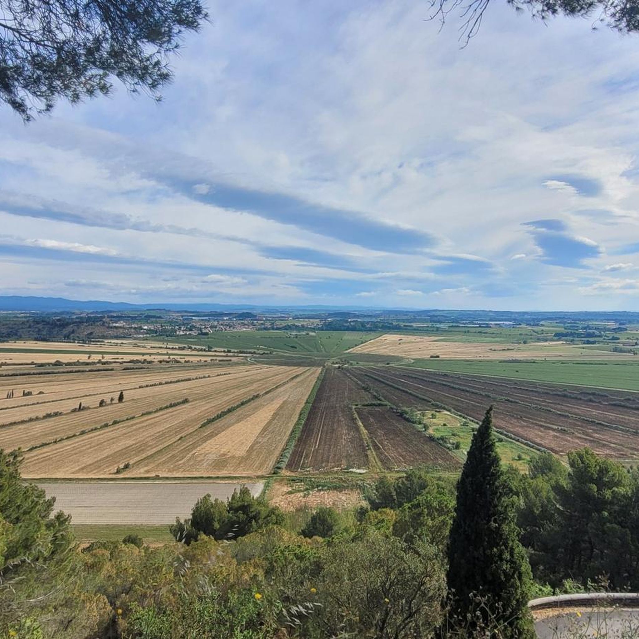
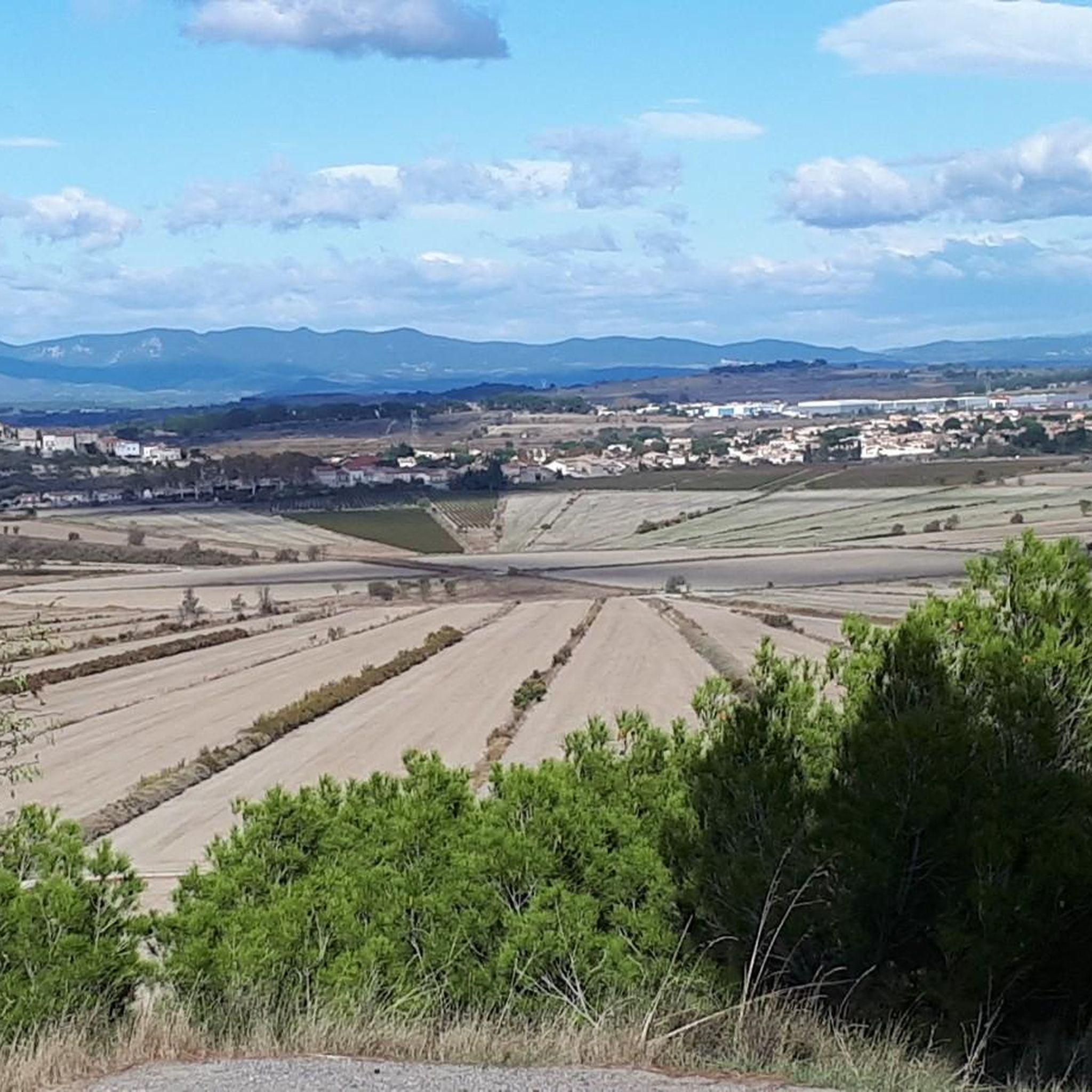
The étang de Montady, now dried up, is one of France's most famous landscapes. This natural basin of 400 ha was dug by the winds, like many others in the Biterrois. The reliefs that surround it, occupied by the oppidum of Ensérune and the old village of Montady, correspond to two valleys from the tertiary era dug by erosion and then filled with hard materials at the end of the Miocene (- 5 million years ago).
0
0
In the heart of the Grand site d'Occitanie, Colombiers invites you for a peaceful stop along the Canal du Midi, at its charming bucolic little river port.
0
0

The Montady pond is a former pond, drained during the Middle Ages, located in the western part of the French department of Hérault, between Béziers and Narbonne. Thanks to drainage canals, the water is channeled towards a central collector, which explains the star-shaped layout of the fields and vineyards. This canal system dates back to the 13th century. Sixty drainage ditches converge at the circular ditch, called the Redondel, in the center of the former pond. The water is then carried away by a counter-sloping ditch towards the Capestang pond and through a tunnel under the Ensérune hill and the Malpas tunnel. The tunnel is located at a depth of 29.5 meters below the Malpas pass and 16 meters below the Canal du Midi tunnel. The pond is visible from the Montady tower, a remnant of the former 12th-century castle, and from the top of the hill, the Ensérune oppidum. Heavy rainfall, like that at the end of October 2019, can cause it to reappear. (Wikipedia)
0
0
Frequently Asked Questions
How many hiking trails are available around Colombiers?
There are 19 hiking trails around Colombiers, offering a variety of experiences for different skill levels. You'll find 10 easy routes and 9 moderate routes to explore.
What kind of terrain can I expect on hikes near Colombiers?
Hiking around Colombiers features diverse landscapes, from tranquil, tree-lined paths along the UNESCO-listed Canal du Midi to gentle hills and varied terrain closer to the Parc Naturel Régional du Haut-Languedoc. You can expect a mix of flat canal-side strolls and more undulating trails through vineyards and natural habitats.
Are there any easy, family-friendly hiking routes in Colombiers?
Yes, Colombiers offers several easy routes perfect for families. For a pleasant walk along the Canal du Midi, consider the Malpas Tunnel – Canal du Midi loop from Colombiers, which is 5.4 km long. Another easy option is the Malpas Tunnel – Malpas Tunnel loop from Colombiers, a 3.4 km path.
What are some notable natural features or landmarks to see while hiking?
The region is rich in natural and historical landmarks. You can hike along the historic Canal du Midi, a UNESCO World Heritage Site, and visit the impressive Fonseranes Locks. The Orb Canal Bridge is another engineering marvel. For scenic views, the Etang de Montady viewpoint – Malpas Tunnel loop from Colombiers offers great panoramas.
Are there any circular hiking routes around Colombiers?
Many of the trails around Colombiers are circular, allowing you to start and end in the same location. Popular loop trails include the Fonséranes Locks – Canal du Midi Lock loop from Colombiers, a 13.7 km moderate route, and the shorter Beautiful view of the plain – Etang de Montady loop from Colombiers, which is 3.1 km and easy.
What do other hikers say about the trails in Colombiers?
The hiking trails in Colombiers are highly regarded by the komoot community, with an average rating of 4.6 stars from over 200 reviews. Hikers often praise the well-maintained paths along the Canal du Midi, the historical points of interest, and the pleasant, varied scenery.
Can I bring my dog on the hiking trails in Colombiers?
Many trails in the Colombiers area, especially those along the Canal du Midi and in open countryside, are generally dog-friendly. However, it's always recommended to keep your dog on a leash, especially near wildlife or in agricultural areas, and to check specific trail regulations if you plan to enter protected natural parks like the Parc Naturel Régional du Haut-Languedoc.
Are there any trails that offer panoramic views?
Yes, several trails provide excellent panoramic views. The Etang de Montady viewpoint – Malpas Tunnel loop from Colombiers offers views of the Etang de Montady. Additionally, the region research mentions points like the hill of Saint Sauveur and the rock of Cayla, which provide commanding views of the ancient chestnut grove, the village, and the Hérault Valley.
What is the best time of year to go hiking in Colombiers?
The Occitanie region generally enjoys a Mediterranean climate, making spring (April-June) and autumn (September-October) ideal for hiking. During these seasons, the weather is typically mild and pleasant, and the landscapes are vibrant. Summer can be very hot, so early morning or late afternoon hikes are recommended if visiting then.
Is public transport available to access hiking trails near Colombiers?
While Colombiers itself is a smaller town, public transport options like local buses may connect it to larger hubs such as Béziers. From Béziers, you might find more extensive connections. For specific trailheads, it's advisable to check local bus schedules or consider driving, as many trails are more easily accessible by car.
Are there any challenging hikes near Colombiers?
While most trails directly around Colombiers are easy to moderate, the nearby Parc Naturel Régional du Haut-Languedoc offers more challenging options. The Gorges de Colombières, for instance, are known for their spectacular vistas and more demanding 13-kilometer trails, often described as having a wild beauty similar to Corsica.
Where can I find parking for hiking trails in Colombiers?
Parking is generally available in and around Colombiers, especially near popular starting points for Canal du Midi trails or in village car parks. For specific trailheads, it's often possible to find roadside parking or designated small car parks. Always check local signage for any restrictions.
Most popular routes around Colombiers
Most popular attractions around Colombiers

Get inspired with the komoot mobile app


Explore more
Browse the best Hikes in other regions.
