The best road cycling routes around Chappes
4.1
(14)
860
riders
37
rides
Road cycling routes around Chappes are situated in the Puy-de-Dôme department of France, offering access to varied landscapes. The area features a network of low-traffic roads that traverse agricultural lands, river valleys, and sections of forest. The terrain is characterized by rolling hills and open countryside, providing diverse scenery for cycling. Road cyclists can expect routes with gentle elevation changes, often following waterways like the Allier river.
Best road cycling routes around Chappes
- The most popular road cycling route is…
Last updated: July 2, 2026
21
riders
81.3km
03:14
380m
380m
Moderate road ride. Good fitness required. Mostly well-paved surfaces and easy to ride.
28
riders
51.7km
01:59
120m
120m
Easy road ride. Great for any fitness level. Mostly well-paved surfaces and easy to ride.

Sign up for free
13
riders
61km
02:29
330m
330m
Moderate road ride. Good fitness required. Mostly well-paved surfaces and easy to ride.
5.0
(1)
9
riders
41.2km
01:40
190m
190m
Easy road ride. Great for any fitness level. Mostly well-paved surfaces and easy to ride.
13
riders
74.4km
02:57
320m
320m
Moderate road ride. Good fitness required. Mostly well-paved surfaces and easy to ride.
Get access to more routes and recommendations from other explorers.
Sign up for free
Already have an account?
Our route recommendations are based on thousands of hikes, rides, and runs completed by other people on komoot.
Start today with a free account
Your next adventure awaits.
Login or Signup



Tips from the Community

Gravel, white gravel paths, dike, and cycle path along the lake, a little bit of grassy path. Rolling route
0
0


A beautiful stretch of water with a cycle path that winds along the edge of the lake. The circuit takes place on the dike and in the Orient Forest with stops at the beach and the bird observatory. A must-do 🚴🌞
0
0

The 50-metre footbridge passes over the Seine reservoir supply channel, allowing cyclists to continue along the lakes cycle route.
0
0

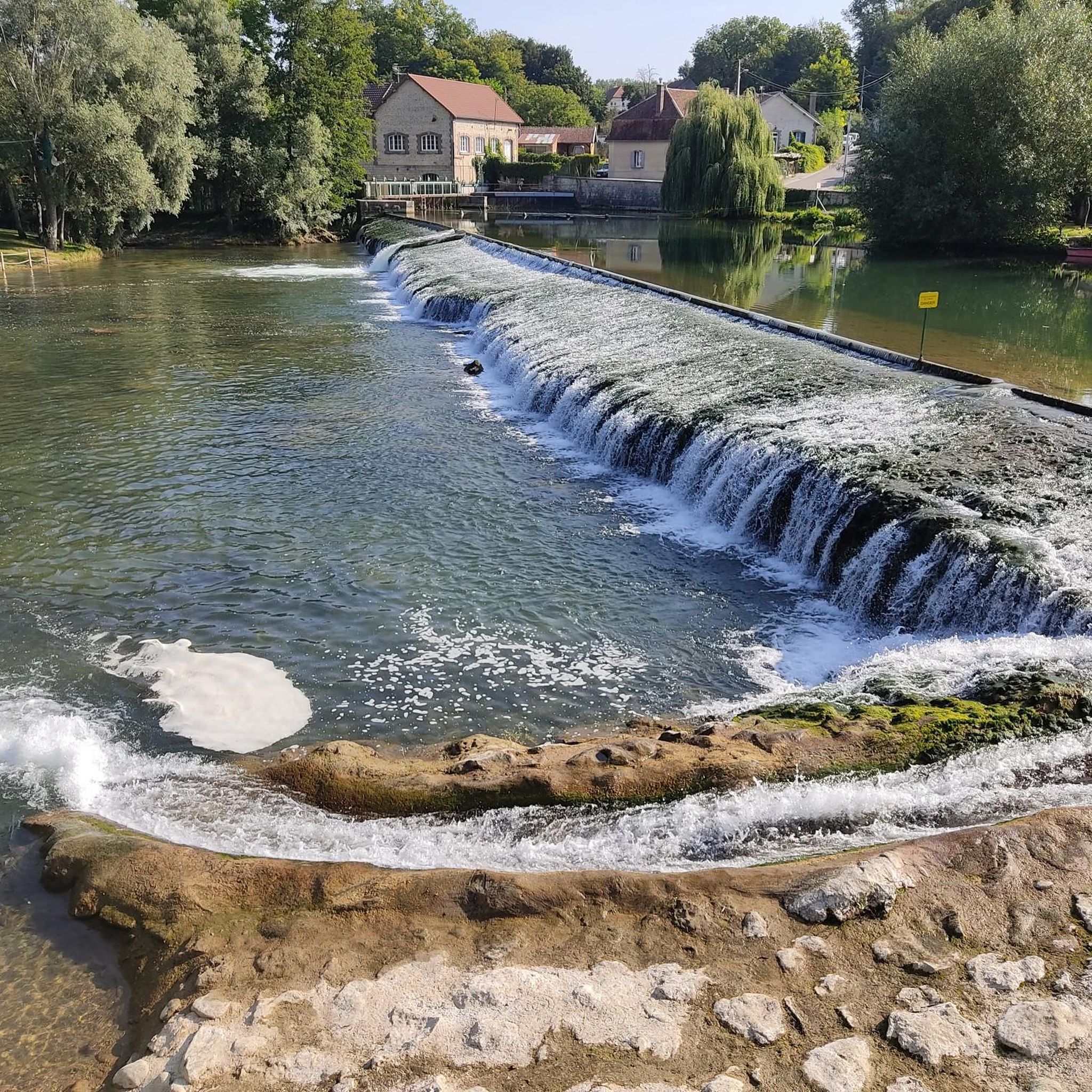
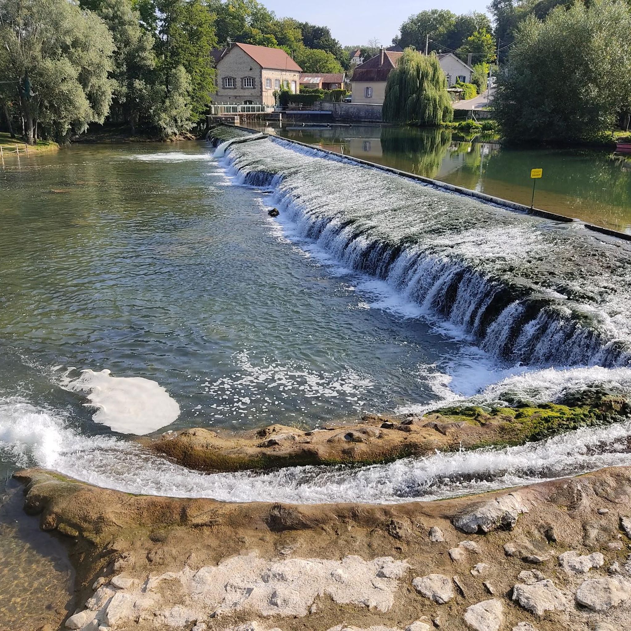
As you pass this U-shaped spillway on the restitution canal in Lusigny-sur-Barse, be sure to take a look at this impressive work of art that manages water levels while showcasing the charm of the area. This unique structure not only regulates the flow of the canal, it also creates a charming waterfall effect as the water flows over its banks, adding to the tranquil ambiance.
1
0

Between Champagne and Burgundy, in the Laignes valley and in the heart of Riceys-Bas, the Château de Ricey-Bas, with its French gardens and its park of more than twenty-five hectares, is part of the great History of France since Robert 1st, Lord of Riceys who established the first foundations in 1086… Surrounded by two arms of the Laignes, the Château de Ricey-Bas, classified as a Historic Monument, is one of the oldest in the region. Transformed by successive families, it continues to be reborn to become today a place of life that can be discovered with complete simplicity.
0
0

Frequently Asked Questions
How many road cycling routes are available around Chappes?
There are over 140 road cycling routes around Chappes, offering a wide variety of options for different skill levels and preferences. You'll find everything from easy rides to more challenging excursions.
What kind of terrain and scenery can I expect when road cycling near Chappes?
Road cycling around Chappes offers diverse scenery, characterized by river valleys, agricultural plains, and sections of forest. The region is close to the Auvergne Volcanoes Regional Natural Park, providing dramatic backdrops, though routes directly from Chappes typically feature rolling hills and open countryside. You'll often follow waterways like the Seine and Allier rivers, with routes offering gentle elevation changes.
Are there road cycling routes suitable for beginners or those looking for an easy ride?
Yes, Chappes offers many easy road cycling routes. Approximately 50 routes are classified as easy, perfect for beginners or those seeking a relaxed ride. An example is the Saint Martin's Church – Chappes Spillway loop from Saint-Parres-lès-Vaudes, which is 22.1 miles (35.7 km) with gentle climbs.
What are some of the more challenging road cycling routes in the Chappes area?
While many routes feature gentle elevation, there are options for more experienced cyclists. The region's proximity to the Auvergne Volcanoes Regional Natural Park means some routes might offer more significant climbs, though direct access to the very top of peaks like Puy de Dôme is restricted. For a moderate challenge, consider the Ricey-Bas Church – Bridge over the river Seine loop from Fouchères, a 35.1 miles (56.4 km) path with moderate elevation gain.
Can I find circular road cycling routes around Chappes?
Yes, many of the road cycling routes around Chappes are designed as loops, allowing you to start and finish in the same location. For instance, the Inlet canal bridge – Lusigny-sur-Barse Spillway loop from Chappes is a 26.2 miles (42.1 km) circular trail through open fields and along water features.
What scenic landmarks or attractions can I see along road cycling routes near Chappes?
Road cycling routes around Chappes can lead you past various points of interest. You might encounter historical sites like the Château de Foolz or the Château de la Cordelière. Natural and man-made features include the Waterfall and arch on the Vélovoie des Lacs d'Orient, the Inlet canal bridge, or the Lusigny-sur-Barse Spillway.
What do other cyclists say about road cycling in Chappes?
The road cycling routes in Chappes are highly rated by the komoot community, with an average score of 4.6 stars from over 20 reviews. Cyclists often praise the varied terrain, the network of low-traffic roads, and the scenic views of river valleys and open countryside.
Are there any family-friendly road cycling routes in Chappes?
Many of the easy and moderate routes around Chappes, characterized by gentle elevation changes and low-traffic roads, are suitable for families. Routes that follow river valleys or traverse agricultural lands often provide a pleasant and safe environment for family cycling. Look for routes marked as 'easy' on komoot for the most family-friendly options.
What is the best time of year for road cycling around Chappes?
The region around Chappes generally offers pleasant cycling conditions from spring through autumn. Spring brings blooming landscapes, while autumn provides vibrant colors. Summers are typically warm, ideal for longer rides, but it's always advisable to check local weather forecasts before heading out.
Are there road cycling routes that include forests or natural parks?
Yes, the area around Chappes features sections of forest and is within reach of natural parks. While the Auvergne Volcanoes Regional Natural Park offers dramatic volcanic terrain, routes directly from Chappes might lead through areas like the Forêt des Colettes or the Livradois-Forez Regional Nature Park, known for its dense forests and volcanic hills. An example of a route touching forested areas is the Forêt de Rumilly – Saint Martin's Church loop from Rumilly-lès-Vaudes.
Where can I find parking for road cycling routes in Chappes?
Many road cycling routes around Chappes start from villages or towns where public parking is typically available. When planning your route on komoot, check the starting point for information on nearby parking facilities. Routes often begin in places like Saint-Parres-lès-Vaudes or Fouchères, which usually have accessible parking for cyclists.
Does the region around Chappes have good cycling infrastructure?
The Puy-de-Dôme department, where Chappes is located, actively promotes cycling. The Departmental Council maintains a network of cycling itineraries, including 'cyclo-sportive' routes on low-traffic roads with directional signage. The broader Auvergne-Rhône-Alpes region boasts an extensive network of 2,700 km of cycle routes and paths, including EuroVélo routes, demonstrating a strong commitment to cycling tourism.
Most popular attractions around Chappes

Get inspired with the komoot mobile app


Explore more
Browse the best Road cycling routes in other regions.
